Anaa facts for kids
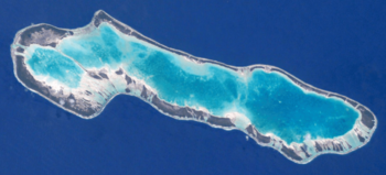
NASA picture of Anaa Atoll
|
|
| Geography | |
|---|---|
| Location | Pacific Ocean |
| Coordinates | 17°20′31″S 145°30′31″W / 17.34194°S 145.50861°W |
| Archipelago | Tuamotus |
| Area | 90 km2 (35 sq mi) (lagoon) 38 km2 (15 sq mi) (above water) |
| Length | 29.5 km (18.33 mi) |
| Width | 6.5 km (4.04 mi) |
| Highest elevation | 11 m (36 ft) |
| Highest point | (unnamed) |
| Administration | |
|
France
|
|
| Overseas collectivity | French Polynesia |
| Administrative subdivision | Îles Tuamotu-Gambier |
| Commune | Anaa |
| Largest settlement | Tuuhora |
| Demographics | |
| Population | 494 (2016) |
| Pop. density | 13 /km2 (34 /sq mi) |
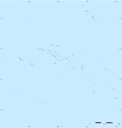
Anaa, also known as Nganaa-nui or Ara-ura, is a beautiful ring-shaped island called an atoll. It is located in French Polynesia, which is a group of islands in the Pacific Ocean. Anaa is part of the Tuamotus archipelago. It lies about 350 kilometers (217 miles) east of Tahiti.
This atoll is oval-shaped, about 29.5 kilometers (18.3 miles) long and 6.5 kilometers (4 miles) wide. Its total land area is 38 square kilometers (14.7 sq mi). About 504 people live there. Anaa is special because its eleven small islands have deeper, more fertile soil than many other atolls in the Tuamotus. The lagoon inside the atoll is shallow and does not have big entrances for boats. However, its water stays fresh through many small channels that you can even walk across.
Contents
Exploring Anaa's Past
Anaa Atoll has a long and interesting history. In the 1600s, the soldiers from Anaa were known for being very strong and brave. They controlled the northwest part of the Tuamotu islands.
Early European Discoveries
- In 1606, a Spanish expedition led by Pedro Fernández de Quirós might have landed near Anaa. They named the island Conversión de San Pablo.
- French explorer Louis Antoine de Bougainville saw Anaa in 1768.
- James Cook also spotted it in 1769. Because of its shape, he called it Chain Island.
- Another Spanish explorer, Domingo de Bonechea, visited Anaa in 1772. He named it Isla de Todos los Santos (All Saints Island) because he arrived on All Saints' Day.
Changes Over Time
In the early 1800s, the Pomaré family from Tahiti took control of Anaa. By the mid-1800s, around 1850, Anaa became a busy center for trading nacre (mother-of-pearl) and copra (dried coconut meat). At this time, about 2,000 people lived on the atoll.
There was a disagreement between American Mormon missionaries and French Catholic missionaries. This led to a local uprising in 1852. French colonial troops had to step in to help.
Anaa has faced tough times due to nature. In 1878 and 1906, severe hurricanes hit the atoll. The entire island was flooded. After another big hurricane in 1983, the main village was rebuilt. It now includes a special shelter that can protect everyone living there.
In 1976, Anaa got its own airport. This made it easier for people to travel to and from the atoll.
Anaa's Natural Features
Anaa is located 66 kilometers (41 miles) south of Faaite Atoll. It is 78 kilometers (48 miles) from Tahanea Atoll and 377 kilometers (234 miles) east of Tahiti. It is an oval-shaped atoll, 29.5 kilometers (18.3 miles) long and 6.5 kilometers (4 miles) wide. Its total land area is 38 square kilometers (14.7 sq mi).
The atoll's coral reef forms eleven small islands, called islets. These islets have deeper and more fertile soil than other atolls in the Tuamotu group. Nine of these islets have names:
- Kereteki
- Mania
- Omanaotika
- Oparari
- Otepipi
- Putuahara
- Teharie
- Tematahoa
- Tukuhora
The lagoon inside Anaa is shallow. There are no large passages for boats to enter from the ocean. It has three main basins. Even though there are no big boat passages, the lagoon's water is refreshed by several shallow channels. You can even walk across these channels!
How Anaa Was Formed
Anaa Atoll was formed from coral growing on top of a very large underwater volcano. This volcano, called the "Anaa Ridge," is about 3,415 meters (11,204 feet) tall from the seafloor. The atoll itself is about 105 meters (344 feet) thick. This whole structure was formed a very long time ago, between 52.5 and 59.6 million years ago.
Animals and Plants
Anaa is home to a special kind of bird called the long-billed warbler. This bird is found only on this atoll. The lagoon also has groups of a type of clam called Cardium fragum.
Tuuhora Village
The main village on Anaa is called Tuuhora. It is also sometimes known as Tukuhora or simply Anaa. About 350 people live there. Other smaller villages like Temarie, Otepipi, Mania, and Tematahoa have fewer people. Sometimes people only live there during certain seasons. The people of Anaa mostly make a living by fishing, growing nacre (mother-of-pearl), and producing copra.
People of Anaa
The population of Anaa was 494 people in 2017. Most people on the atoll earn their living from fishing, farming mother-of-pearl, and making copra.
Here's how the population of Anaa has changed over the years:
| 1983 | 1988 | 1996 | 2002 | 2007 | 2012 | 2017 | ||
|---|---|---|---|---|---|---|---|---|
| 400 | 426 | 411 | 435 | 463 | 496 | 494 | ||
| Sources: ISPF and Government of French Polynesia. | ||||||||
Religion in Anaa
Today, most people in Anaa are Christians. The Catholic Church has a building on the atoll in Tukuhora called St. Joseph's Church (Église de Saint-Joseph). This church is part of the main Catholic area based in Papeete, Tahiti.
Anaa's Economy
The main ways people make money on Anaa are through fishing and fish farming. They also produce copra, which comes from coconut trees grown on almost all the small islands (motus).
Anaa has an airfield (airport) near the main town of Tukuhora. Its airport code is AAA. The runway is 1,400 meters (4,593 feet) long. On average, about 140 flights land there each year, bringing around 3,500 passengers.
The Commune of Anaa
|
Anaa
|
|
|---|---|
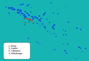
Location (in red) within the Tuamotu Archipelago
|
|
| Country | France |
| Overseas collectivity | French Polynesia |
| Subdivision | Îles Tuamotu-Gambier |
| Area
1
|
55.7 km2 (21.5 sq mi) |
| Population
(2017)
|
811 |
| • Density | 14.560/km2 (37.71/sq mi) |
| Time zone | UTC−10:00 |
| INSEE/Postal code |
98711 /
|
| 1 French Land Register data, which excludes lakes, ponds, glaciers > 1 km2 (0.386 sq mi or 247 acres) and river estuaries. | |
The atoll of Anaa is part of a larger local government area called the Commune of Anaa. A commune is like a municipality or local district. This commune is part of the administrative subdivision of the Îles Tuamotu-Gambier.
The Commune of Anaa also includes other atolls:
- Faaite (which has people living on it)
- Tahanea (which is not inhabited)
- Motutunga (which is not inhabited)
The main village for the entire commune is Tuuhora, located on Anaa Atoll.
Commune Overview
Here is a quick look at the atolls within the Commune of Anaa:
| Atoll | Main Village |
Population 2017 |
Land Area (km2) |
Lagoon (km2) |
Location |
|---|---|---|---|---|---|
| Anaa Atoll | |||||
| Anaa | Tuuhora | 494 | 37.7 | 90 | 17°20′S 145°30′W / 17.333°S 145.500°W |
| Faaite Atoll | |||||
| Faaite | Hitianau | 317 | 18.0 | 227 | 16°43′S 145°19′W / 16.717°S 145.317°W |
| Motutunga | - | - | 126 | 17°04′S 144°17′W / 17.067°S 144.283°W | |
| Tahanea | - | - | 522.5 | 16°50′S 144°45′W / 16.833°S 144.750°W | |
| Total for Anaa Commune | Tukuhora | 811 | 55.7 | 965.5 | |
Faaite Atoll
Faaite is another atoll located about 60 kilometers (37 miles) north of Anaa. Its total area is 230 square kilometers (89 sq mi). The dry land area is about 9 square kilometers (3.5 sq mi). The lagoon inside Faaite has a channel that boats can use to reach the ocean. The main village on Faaite is Hitianau, with a population of 246 people. John Turnbull discovered Faaite in 1802. He was one of the first traders in the Pacific to use the route from Tahiti to Hawaii. Faaite has also been known as Miloradovich.
Tahanea Atoll
Tahanea is a larger atoll, covering 63 square kilometers (24 sq mi). It has three passages that lead into its lagoon. No one lives on Tahanea permanently, but people visit it sometimes. Domingo Bonaechea discovered it in 1772 and named it San Julian. It has also been called Tchitschagof.
Motutunga Atoll
Motutunga is an atoll where no one lives. Its lagoon has a passage, but it is not deep enough for boats to use. Domingo Bonaechea named it San Blas. It has also been known as Adventure Island.
See also
 In Spanish: Anaa (atolón) para niños
 | Kyle Baker |
 | Joseph Yoakum |
 | Laura Wheeler Waring |
 | Henry Ossawa Tanner |


