Andrews, South Carolina facts for kids
Quick facts for kids
Andrews
|
|
|---|---|
 |
|

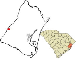
Location in Georgetown County and the state of South Carolina.
|
|
| Country | United States |
| State | South Carolina |
| Counties | Georgetown, Williamsburg |
| Area | |
| • Total | 2.21 sq mi (5.73 km2) |
| • Land | 2.21 sq mi (5.73 km2) |
| • Water | 0.00 sq mi (0.00 km2) |
| Elevation | 26 ft (8 m) |
| Population
(2020)
|
|
| • Total | 2,575 |
| • Density | 1,165.16/sq mi (449.77/km2) |
| Time zone | UTC-5 (EST) |
| • Summer (DST) | UTC-4 (EDT) |
| ZIP code |
29510
|
| Area codes | 843, 854 |
| FIPS code | 45-01450 |
| GNIS feature ID | 1244882 |
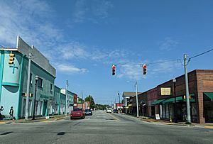
Andrews is a town located in the state of South Carolina, in the United States. It is found in two counties: Georgetown and Williamsburg. In 2020, about 2,575 people lived there.
Andrews has its own small airport, Robert F. Swinnie Airport. It is used for general aviation, which means smaller planes use it. The airport is about 2 miles (3.2 km) east of the town's center.
Geography
Andrews is mostly in western Georgetown County. A small part of the town reaches into Williamsburg County.
A major road, U.S. Route 521, goes around the south side of town. It then passes through the west side. This highway can take you about 62 miles (100 km) northwest to Sumter. It also goes about 17 miles (27 km) east to Georgetown, which is the main city of Georgetown County.
Another road, South Carolina Highway 41, leads northeast about 24 miles (39 km) to Hemingway. It also goes southwest about 15 miles (24 km) to Jamestown. The big city of Charleston is about 59 miles (95 km) southwest of Andrews.
The town of Andrews covers a total area of 2.2 square miles (5.7 square kilometers). All of this area is land.
Demographics
| Historical population | |||
|---|---|---|---|
| Census | Pop. | %± | |
| 1920 | 1,968 | — | |
| 1930 | 1,712 | −13.0% | |
| 1940 | 2,008 | 17.3% | |
| 1950 | 2,702 | 34.6% | |
| 1960 | 2,995 | 10.8% | |
| 1970 | 2,839 | −5.2% | |
| 1980 | 3,129 | 10.2% | |
| 1990 | 3,050 | −2.5% | |
| 2000 | 3,068 | 0.6% | |
| 2010 | 2,861 | −6.7% | |
| 2020 | 2,575 | −10.0% | |
| U.S. Decennial Census | |||
2020 Census Information
In 2020, the town of Andrews had 2,575 people living there. There were 1,049 households, which are groups of people living together. About 754 families also lived in the town.
The census also looks at the different groups of people living in an area. In Andrews, the largest group was Black or African American people, making up about 62.5% of the population. White people made up about 31.5%. Other groups like Native American, Asian, Pacific Islander, and people of mixed races made up smaller percentages. About 3.2% of the population was Hispanic or Latino.
History
The area where Andrews is now was first settled as two smaller towns. These were Rosemary and Harpers Crossroads. They grew up along the Georgetown and Western Railroad, which started running in 1886.
In 1905, another railroad, the Seaboard Air Line Railroad, built a route through the area. They also built a large shop to fix trains. Because of this growth, the people decided to combine the two towns. In 1909, voters agreed to make them one community. They named the new town Andrews. It was named after Colonel Walter H. Andrews. He was important in helping the towns join together. Colonel Andrews worked for a lumber company and was mayor for much of the 1920s.
A town hall was built in 1915. Today, this building is a museum. By 1919, Andrews had grown to about 2,000 people. It kept growing quickly. In the 1920s, Andrews was known as one of the fastest-growing towns in the United States for its age.
At that time, there were two main schools: Andrews School and Rosemary School. These schools were separate for different groups of people. Andrews School was for white students, and Rosemary School was for black students.
When the Great Depression started in the 1930s, Andrews faced hard times. The population dropped by 700 people because the Seaboard railroad reduced its work. In 1932, the local economy got another hit when a big lumber company, Atlantic Coast Lumber Co., closed its nearby factory. The lumber business never became as important in the area again.
Things started to get better in the late 1930s. An International Paper paper mill was built in Georgetown County, which helped the economy.
After World War II, a group called the Andrews Development Board was formed. Their goal was to bring new businesses to the town. Many new industries came, including lumber companies, a livestock market, an ice company, and a knitting mill.
In 1970, the schools in Andrews were brought together. Rosemary School became a middle school. Andrews School became the elementary and high school. Later, in 1984, Andrews Elementary School was built. New middle and high school buildings were completed in 2000. The local library branch also expanded in 2010. Andrews celebrated its 100th birthday in 2009.
Education
Public schools in Andrews are managed by the Georgetown County School District. This district runs three schools in town:
- Andrews Elementary School: This school is for younger students, from child development programs up to 5th grade.
- Rosemary Middle School: This school serves students in 6th, 7th, and 8th grades.
- Andrews High School: This school is for older students, from 9th to 12th grade.
There is also a private school in Andrews called Trinity Christian Academy.
Andrews has a public library. It is a branch of the Georgetown County Library system.
Notable people
Some famous people have connections to Andrews:
See also
 In Spanish: Andrews (Carolina del Sur) para niños
 | William M. Jackson |
 | Juan E. Gilbert |
 | Neil deGrasse Tyson |


