
Ant Hill (Zion) facts for kids
Quick facts for kids Ant Hill |
|
|---|---|

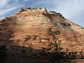
East aspect, viewed from Highway 9
|
|
| Highest point | |
| Elevation | 6,641 ft (2,024 m) |
| Prominence | 321 ft (98 m) |
| Isolation | 0.65 mi (1.05 km) |
| Parent peak | The Scarlet Begonia (6,995 ft) |
| Geography | |

Ant Hill
Location in Utah

Ant Hill
Location in the United States
|
|
| Location | Zion National Park Washington County, Utah United States |
| Parent range | Colorado Plateau |
| Topo map | USGS Springdale East |
| Geology | |
| Age of rock | Jurassic |
| Type of rock | Navajo sandstone |
| Climbing | |
| Easiest route | class 4 scrambling |
Ant Hill is a mountain that stands 6,641 feet (about 2,024 meters) tall. You can find it in Zion National Park, which is in Washington County, southwest Utah, United States. This mountain is made of white rock called Navajo Sandstone. It towers 1,400 feet (425 meters) above the Zion – Mount Carmel Highway.
Ant Hill is located about 1.65 miles (2.65 km) east-northeast of The East Temple. It's also about 2.4 miles (3.8 km) west-northwest of Checkerboard Mesa. Rain and melted snow from Ant Hill flow into small streams that eventually join the Virgin River. Even though its name sounds small, climbing this mountain is very challenging and should only be attempted by experienced climbers.
Climate
The best times to visit Ant Hill are during spring and fall. The area has a Cold semi-arid climate. This means that the coldest month usually has an average temperature below 32 °F (0 °C). Also, at least half of the yearly rain and snow falls during spring and summer. This desert climate gets less than 10 inches (254 mm) of rain each year. Snowfall in winter is usually light.
Images for kids
-
South aspect
-
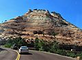
South aspect
-
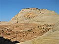
Ant Hill from ENE near Aires Butte
-
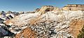
Ant Hill (center) and parent The Scarlet Begonia (upper right corner)
.jpg)


