
Antarctic ice sheet facts for kids
Quick facts for kids Antarctic Ice Sheet |
|
|---|---|
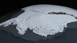
This image shows the Antarctic Ice Sheet from the Pacific Ocean side. You can see the West Antarctic Ice Sheet in front and the East Antarctic Ice Sheet in the back. The Antarctic Peninsula is on the left.
|
|

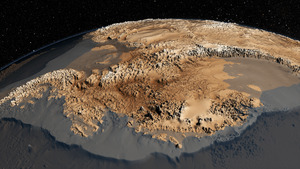
A map of Antarctica. The white areas are the grounded ice sheet, gray areas are floating ice shelves, and brown areas are land without ice.
|
|
| Type | Ice sheet |
| Location | Antarctica |
| Area | 14×106 km2 (5.4×10⁶ sq mi) |
| Thickness | 2.2 km (1.4 mi) on average, 4.9 km (3.0 mi) at maximum |
| Status | Ongoing net loss of ice, regionally variable |
The Antarctic Ice Sheet is a huge sheet of ice that covers almost all of Antarctica. It covers about 14 million square kilometres (5.4 million square miles) and is more than 2 kilometres (1.2 mi) thick on average. This makes it the biggest ice sheet on Earth.
It holds 26.5 million cubic kilometres (6,400,000 cubic miles) of ice. This is about 61% of all the fresh water on our planet! Most of Antarctica is covered in ice. Only a few places, like some dry valleys, mountain peaks (called nunataks), and small parts of the coast, are free of ice.
Scientists often divide the Antarctic Ice Sheet into three main parts: the Antarctic Peninsula (AP), the East Antarctic Ice Sheet (EAIS), and the West Antarctic Ice Sheet (WAIS). These parts are different in how much ice they gain or lose, how the ice moves, and their land shapes.
The East Antarctic Ice Sheet is much larger and higher than the West Antarctic Ice Sheet. This makes it stronger against changes in climate. In the 20th century, the EAIS mostly stayed cool. However, the West Antarctic Ice Sheet warmed by more than 0.1 °C every ten years from the 1950s to 2000. Since 1957, the whole continent has seen a warming trend of more than 0.05 °C per decade.
As of early 2020s, the East Antarctic Ice Sheet is still gaining some ice. This is because more snow falls and freezes on top of it. But the West Antarctic Ice Sheet is losing a lot of ice. This loss comes from large glaciers like Thwaites and Pine Island Glacier.
Scientists estimate that by the year 2100, the ice melting from Antarctica could add about 11 cm (5 in) to global sea level rise. The West Antarctic Ice Sheet sits deep below sea level. This makes it vulnerable to a process where melting can speed up quickly. It is hard for scientists to predict exactly how fast this will happen. If this process starts, it could make sea levels rise even more. This is especially true if the planet gets much warmer.
The melting ice also adds a lot of fresh water to the ocean. This is about 1100 to 1500 billion tons each year. This fresh water mixes with the salty ocean water, making it less salty. This can affect how ocean currents move, especially deep currents in the Southern Ocean. Scientists are studying how this might change ocean circulation over hundreds of years.
Scientists are concerned that the West Antarctic Ice Sheet could melt away over a very long time. This could happen even if global warming does not get worse. To help protect it, global temperatures would need to drop significantly. This melting process could take thousands of years. However, if the Earth continues to warm quickly, it could happen much faster.
If the West Antarctic Ice Sheet melts completely, it could cause global sea levels to rise by about 3.3 m (10 ft 10 in). If even more ice melts, this rise could reach 4.3 m (14 ft 1 in). After the ice melts, the land underneath can slowly rise. This process, called isostatic rebound, might add another 1 m (3 ft 3 in) to sea levels over a thousand years.
The East Antarctic Ice Sheet is much more stable. Even with current warming, it is expected to contribute only a small amount (0.5 m (1 ft 8 in) to 0.9 m (2 ft 11 in)) to sea level rise. This is a tiny part of its total ice volume, which is 53.3 m (175 ft). If global temperatures rise by about 3 °C (5.4 °F), some parts of the East Antarctic Ice Sheet, like the Wilkes Basin, could melt over about 2,000 years. This would add up to 6.4 m (21 ft 0 in) to sea levels. For the entire East Antarctic Ice Sheet to melt, global warming would need to be much higher, between 5 °C (9.0 °F) and 10 °C (18 °F).
Contents
What is the Antarctic Ice Sheet?
The Antarctic Ice Sheet covers an area of almost 14 million square kilometres (5.4 million square miles). It contains 26.5 million cubic kilometres (6,400,000 cubic miles) of ice. One cubic kilometer of ice weighs about 0.92 billion tons. This means the entire ice sheet weighs around 24,380,000 billion tons! This ice is about 61% of all the fresh water on Earth.
The only other huge ice sheet on Earth is the Greenland ice sheet in the Arctic.
Parts of the Ice Sheet
The Transantarctic Mountains divide the Antarctic Ice Sheet into two main parts. These are the East Antarctic Ice Sheet (EAIS) and the smaller West Antarctic Ice Sheet (WAIS). Some scientists also consider the ice on the relatively small Antarctic Peninsula to be a third ice sheet. This is because its ice flows differently from the WAIS.
Together, these ice sheets are about 2 kilometres (1.2 mi) thick on average. Even the Transantarctic Mountains are mostly covered in ice. Only some mountain tops and the McMurdo Dry Valleys are currently free of ice. Some parts of the coast also have bare rock. In the past, during an ice age called the Late Cenozoic Ice Age, even more of these areas were covered by ice.
The East Antarctic Ice Sheet sits on a large landmass. But in some places, the West Antarctic Ice Sheet sits on land that is more than 2,500 meters (8,200 feet) below sea level! If the ice wasn't there, it would be ocean floor.
The West Antarctic Ice Sheet is called a "marine-based" ice sheet. This means its base is below sea level. Its edges float on the ocean, forming ice shelves. The West Antarctic Ice Sheet is surrounded by large floating ice shelves. These include the Ross Ice Shelf and the Filchner–Ronne Ice Shelf. It also has fast-moving rivers of ice, called outlet glaciers, that flow into the Amundsen Sea. The Thwaites Glacier and Pine Island Glacier are two very important ones.
Changes in the Ice Sheet
Warming Trends
Antarctica's average ice mass has been changing since 2002. It has been losing about 100 billion metric tons of ice per year.

Ice Melting and Sea Levels
The melting of ice from Antarctica adds a lot of fresh water to the ocean. This is about 1100 to 1500 billion tons each year. This meltwater mixes with the Southern Ocean, making its water less salty. This change in saltiness affects how the ocean layers mix. It has a big impact on the long-term movement of Southern Ocean currents.
Since the 1970s, scientists have observed changes in these currents. Some currents near the surface have sped up. Deep ocean currents, which rely on salty water, have slowed down. These changes are important for the global ocean system.

Scientists are still studying these effects. They believe these changes are likely to continue in the future. Computer models suggest that deep currents will keep weakening. Surface currents may continue to strengthen. However, there is some uncertainty. This is because it's hard to predict future ice loss from Antarctica. Also, ocean models are still improving how they show ocean layers.
Some studies suggest that the Southern Ocean currents could weaken significantly by 2050. It is possible that these currents could even stop moving in the future. This would be a big change that would be hard to reverse. Similar changes are being studied for currents in the Atlantic Ocean.
Such a big change in ocean currents could affect rainfall patterns around the world. It could also impact ocean life and fishing in the Southern Ocean. These effects are expected to happen over many centuries.
Antarctica's Past Ice

Antarctica started to get covered in ice a very long time ago. This began between 60 and 45.5 million years ago. It increased greatly about 34 million years ago. At that time, the amount of carbon dioxide (CO2) in the air was decreasing. This decrease in CO2 was the main reason for Antarctica's glaciation.
The opening of the Drake Passage (a waterway between South America and Antarctica) may have also played a role. However, models suggest that falling CO2 levels were more important.
The West Antarctic Ice Sheet melted a bit during a warm period called the early Pliocene epoch. This was about five to three million years ago. During this time, the Ross Sea opened up. But the East Antarctic Ice Sheet, which sits on land, did not melt much.
See also
- Bibliography of Antarctica
- Filchner-Ronne Ice Shelf
- Geography of Antarctica
- List of glaciers in the Antarctic
- Ross Ice Shelf
- Subglacial lake
