
Antofagasta de la Sierra facts for kids
Quick facts for kids Antofagasta de la Sierra |
|
|---|---|

Alumbrera cinder cone viewed from a lava field
|
|
| Highest point | |
| Elevation | 4,000 metres (13,123 ft) (uncertain) |
| Geography | |

Antofagasta de la Sierra
Location in Argentina
|
|
| Parent range | Andes |
| Geology | |
| Age of rock | Holocene |
| Mountain type | Scoria cones |
| Last eruption | Unknown |
Antofagasta de la Sierra is a special area in Argentina where you can find many volcanoes. It's called a volcanic field because it has several volcanoes close together, instead of just one giant one. The main types of volcanoes here are called scoria cones. These are cone-shaped hills made from bits of volcanic rock that were thrown out during eruptions. The most well-known cones in this area are La Laguna, Jote, and Alumbrera. Scientists have studied La Laguna and Alumbrera quite a bit. They believe some of these volcanoes are very old, millions of years old, but others might have erupted more recently, even in the last 10,000 years!
Contents
Volcanoes in the Andes
Where Volcanoes Are Found
The Andes mountains, which stretch along the western side of South America, are famous for their many volcanoes. These volcanoes are grouped into four main areas: the Northern, Central, Southern, and Austral Volcanic Zones. Most of these volcanoes exist because the Nazca Plate (a huge piece of the Earth's crust) is slowly sliding underneath the South America Plate. This process is called subduction.
The Central Volcanic Zone is where Antofagasta de la Sierra is located. This zone runs along the Western Andes and the Altiplano, which is a high plateau. Over millions of years, the volcanoes in this area have changed their position and spread out. This happened because of shifts deep within the Earth. Sometimes, cracks in the Earth's crust, called strike-slip faults, help guide the molten rock (magma) to the surface.
About 7 million years ago, big changes happened in this region. Huge amounts of volcanic ash and rock, called ignimbrites, erupted from places like Galán. Smaller volcanoes also appeared, erupting a type of lava called basaltic andesite. These smaller volcanoes can be different shapes, like lava domes (dome-shaped mounds), lava flows (rivers of molten rock), maars (wide, flat craters), scoria cones (cone-shaped hills), and tuff rings (low, flat rings of volcanic ash).
Antofagasta's Local Volcanoes
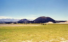
The Antofagasta de la Sierra volcanic field is located in a long valley in the Catamarca Province of Argentina. The La Laguna and Alumbrera cones are the most studied ones. They are about 5 to 7 kilometers (3 to 4 miles) south of the town of Antofagasta de la Sierra. These volcanoes are surrounded by dark fields of hardened lava. The Jote volcanoes are a group of cinder cones and lava flows.
The Alumbrera cone is about 164 meters (538 feet) tall. It has an oval shape, stretching about 1.3 kilometers (0.8 miles) long. This shape might be because of strong winds during its formation. The cone also shows signs of having partly collapsed on one side. It has a crater about 50 meters (164 feet) wide and some cracks, called fissure vents, where lava could have come out. Alumbrera produced a large lava flow field that covers about 41.3 square kilometers (16 square miles) around the cone. Inside Alumbrera's crater, you can find small volcanic rocks called lapilli, along with colorful minerals like alum, ochre, and sulfur.
La Laguna is a bit smaller than Alumbrera. Its cone is 153 meters (502 feet) high and about 1.1 kilometers (0.7 miles) wide. Its crater is 23.5 meters (77 feet) deep. Like Alumbrera, La Laguna also has a fissure vent and a lava flow field, though smaller, covering about 6.8 square kilometers (2.6 square miles).
Both La Laguna and Alumbrera were fed by cracks in the Earth that run northwest. This is a bit unusual because most cracks in the area run in different directions. The surfaces of the volcanic rocks have been shaped by wind, which has carved grooves into them. It seems that so much magma came out of these two volcanoes that it forced open new cracks in the ground.
What the Rocks Are Made Of
The rocks from Alumbrera and La Laguna are a type of volcanic rock called basaltic trachyandesite to trachybasalt. These rocks often have a "porphyritic" texture, meaning they have larger crystals (called phenocrysts) scattered within a finer-grained material. These crystals are usually olivine and plagioclase or clinopyroxene. The Jote lavas are similar to those from La Laguna. Interestingly, older lavas from La Laguna have a slightly different chemical makeup, more like rocks found in typical volcanic arcs. Local people used to mine "alum" (which was actually a mix of aluminium sulfate and magnesium sulfate) from Alumbrera.
Eruptions and History
How They Erupted
Eruptions at Alumbrera happened in two main stages. The first stage produced thick, pasty lava flows and rough, blocky lava flows called aa lava. The second stage also had lava, but it also produced small, fast-moving clouds of hot gas and ash called pyroclastic flows, and a blanket of ash and rock pieces called tephra. Pieces of volcanic rock, called scoria, fell as far as 15 kilometers (9 miles) east of Alumbrera. During this second stage, part of Alumbrera's cone collapsed, and then it had Strombolian eruptions, which are explosive but not too violent, throwing out lava bombs (blobs of molten rock).
La Laguna also had two phases of activity. First, it erupted several lava flows that are now quite worn down, forming an older cone. Later, in a second phase, it threw out more lava bombs and scoria, which built a newer cone and two more lava flow fields. After the magma pressure dropped at both volcanoes, water might have entered the volcanic vents, causing some explosive activity where magma and water mixed. These eruptions probably lasted anywhere from several weeks to several years.
When They Erupted
Scientists have used different methods to figure out when these volcanoes erupted. One lava flow at La Laguna cone is about 340,000 years old. Other studies in the Puna region have given ages ranging from 3.2 to 4.5 million years ago for Jote, and 0.3 to 7.3 million years ago for Alumbrera and La Laguna. The oldest age might refer to a flat-topped hill (mesa) near the Alumbrera lava field. The youngest age found for Alumbrera cone is about 37,000 years old.
We don't have any records of these volcanoes erupting in recent history. In 1907, people thought they were extinct (no longer active). However, the very fresh look of the Alumbrera cone suggests it might have erupted during the Holocene period, which started about 10,000 years ago. If these volcanoes were to become active again, they could cause ash to fall over a large area and create dangerous pyroclastic flows close to the volcano.
Other Interesting Facts
Between the Antofagasta and Alumbrera volcanoes, there is a lake called Antofagasta lake. The area around the volcanoes is mostly dry, with shrub steppe plants, and it gets a lot of sunshine. The Antofagasta River flows from the north and forms a large wetland before reaching the relatively deep Antofagasta lake. The Alumbrera volcano is right next to the lake on its southern side. Before the volcanoes formed and blocked the river, it might have flowed further south. There's also an important archeological site located on the Antofagasta volcano, showing that people have lived here for a long time.
Gallery
-
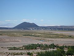
Antofagasta cone from the town
-
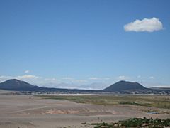
Alumbrera and Antofagasta cones
-
-
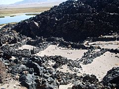
A pucara (ancient fortress) close to the volcanoes


See also
 In Spanish: Volcán Antofagasta para niños
- List of volcanoes in Argentina
