
Appin, New South Wales facts for kids
Quick facts for kids AppinNew South Wales |
|||||||||||||||
|---|---|---|---|---|---|---|---|---|---|---|---|---|---|---|---|

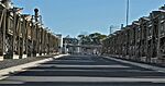
Northern entry to Appin
|
|||||||||||||||

Appin
Location in New South Wales
|
|||||||||||||||
| Population | 3,213 (2021 census) | ||||||||||||||
| Postcode(s) | 2560 | ||||||||||||||
| Elevation | 240 m (787 ft) | ||||||||||||||
| Location |
|
||||||||||||||
| LGA(s) | Wollondilly Shire | ||||||||||||||
| Region | Macarthur | ||||||||||||||
| State electorate(s) | Wollondilly | ||||||||||||||
| Federal Division(s) | Hume | ||||||||||||||
|
|||||||||||||||
Appin is a town in New South Wales, Australia. It is located on the edge of Sydney, in a region called Macarthur. Appin is also in the traditional lands of the Tharawal people. It is about 16 km (10 mi) south of Campbelltown and 35 km (22 mi) northwest of Wollongong.
Appin's Past: A Look at History
Early Days and First Settlers
Appin is part of the traditional lands of the Dharawal Aboriginal people. Their stories tell of a great fire. A leader named Wiritjiribin guided people to safety in a cool gully. Those who died in the fire became animals. Wiritjiribin turned into a lyrebird, which became a special symbol for peace. This area, called Gawaigl, became a meeting place for many Aboriginal groups.
For some years, European settlement was not allowed in the Appin area. This was because a small herd of cattle had escaped from the Sydney Cove settlement. This area was known as the 'Cowpastures'. Governor Macquarie wanted to protect these cattle to help feed the colony. He made a rule that no one could enter the Cowpastures without permission.
In 1807, a naturalist named George Caley explored the area. European settlement officially began in 1811. Governor Macquarie gave 1,000 acres (4.0 km2) of land to William Broughton. Over the next five years, smaller pieces of land were given to former soldiers and freed convicts. Governor Macquarie named the area 'Appin' after a place in Scotland. This was where his wife, Elizabeth, was born.
In the mid-1800s, a visitor named Mrs. Allan McPherson described Appin as a small, quiet village. She mentioned the difficult roads and how she was once stuck there for three days due to heavy rain.
The Appin Massacre
In March 1816, a group of settlers were attacked near Silverdale by some Aboriginal people. Four settlers were killed. Governor Lachlan Macquarie then ordered an armed group to respond. On April 17, this group attacked an Aboriginal camp. At least fourteen Aboriginal people died in this event.
Appin Mine Disaster
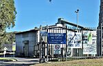
On July 24, 1979, a terrible accident happened at the Appin coal mine. An explosion occurred about 600 meters underground. It was caused by sparks from a fan control box. These sparks ignited a dangerous buildup of methane gas. This explosion killed 14 people.
After the disaster, a special investigation was held. This led to much stricter safety rules for all mines. It was suggested that mines should have automatic devices to constantly check for gases. Also, a special officer should be in charge of ventilation, and more mine inspectors were needed.
Historic Places in Appin
Appin has several places that are listed for their historical importance:
- Cataract Road, Cataract: Cataract Dam
- Wilton Road: Windmill Hill, Appin
Famous People from Appin
One important early settler in Appin was Andrew Hamilton Hume. He was the father of the famous explorer Hamilton Hume. Hamilton Hume and his brother John explored the local area a lot. They often traveled with Duall, a Dharawal man. Hamilton Hume became an expert at living in the Australian bush. This prepared him for his major journey in 1824. He set out with William Hovell to explore the land between Sydney and Port Phillip.
Appin is also the birthplace of John Fuller. He was better known as the bushranger Dan 'Mad Dog' Morgan.
Rachel Henning, a writer, also spent time in Appin. She wrote about the area, noting that the soil was poor and it was a very dry part of Australia. She mentioned that even when other nearby towns had rain, Appin often did not.
Farming and Industry in Appin
For many years, Appin was a big area for growing wheat and dairy farming. However, a plant disease called wheat rust and new railways made it less important for these crops.
From 1869, Appin became a key supplier of Sydney's water. This was due to the Upper Nepean Scheme. This project involved building four large dams and about 40 miles (64 km) of canals and tunnels. These supplied water to the Prospect Reservoir.
The Appin Colliery, a coal mine, opened in 1962. It uses a method called longwall mining to get coal from the Bulli Seam. The West Cliff Colliery also opened in 1976.
Town Development and Services
A plan for the town was finished in 1834. Some of the street names suggested then are still used today. One of these is Toggerai, which is the Dharawal name for the upper parts of the Georges River. A path from Campbelltown was used from 1815. As more people settled along the coast, new routes to Sydney went through Appin. This increased the town's growth and wealth.
Appin had a permanent Post Office by 1841. A telephone line was connected to it in 1888. However, Appin did not get electricity until 1945. Even though it is near several large dams, Appin did not get a piped water supply until 1961.
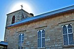
Many old sandstone buildings can still be seen in Appin's main area on Appin Road. These include the old Courthouse and Gaol (from the 1860s). There is also the old Appin Inn (1826) and a stone cottage built around 1840. St. Bede's Roman Catholic Church, built between 1834 and 1837, is another historic building. Other old buildings include the disused motor garage at Darcy's Corner (1955), the Appin Hotel (1840), and St Mark The Evangelist Church (1843).
Appin Today
In 2021, Appin had a population of 3,213 people.
- About 5.2% of the people were Aboriginal and Torres Strait Islander.
- Most people (86.1%) were born in Australia. The next largest group (3.0%) was born in England.
- Most people (90.3%) spoke only English at home.
- The most common religions were No Religion (38.1%), Catholic (29.3%), and Anglican (18.1%).
Community Life and Facilities
The Wollondilly Mobile Library visits Appin every week. Appin has a Playgroup and a Mobile PreSchool. There is also a Community Hall and two sportsgrounds. A special area for pets to run off-leash is near Wonson Oval.
The Appin Volunteer Bush Fire Brigade started in 1944. It is now called the Appin Rural Fire Service. Their current fire station opened in 2002.
Surrounding Areas of Interest
The 16th World Scout Jamboree was held at the nearby Cataract Scout Camp. This was the first time such a Jamboree was held in the Southern Hemisphere. Many Australian Scout Jamborees have also taken place there.
The Dharawal State Recreation Area and Nature Reserve is located to the east of Appin. Appin is part of the Upper Georges River Catchment area.
The Bureau of Meteorology has a Weather Watch radar station near Bulli. It is known as the "Sydney (Appin) radar". This radar covers a large area, including Newcastle and Wollongong.
Jobs and Industries
The coal mines continue to be a major source of jobs in Appin. Inghams Enterprises also operates several large chicken farms. An industrial area has been built south of Appin. This area also has the Macarthur Water Treatment Plant. This plant was finished in 1995. It supplies water to the Camden, Campbelltown, and Wollondilly areas.
Education in Appin
Appin Public School opened in 1867. Before this, there were Catholic and Anglican schools in the area. However, both of these schools closed by 1870.
Today, students who go to high school usually attend schools in Campbelltown or other nearby areas. For further education, students can go to Western Sydney University in Campbelltown. They can also attend the University of Wollongong or Campbelltown TAFE.
Sports in Appin
- North of town, you can find the Appin Greyhound Track. There is also the Appin Motocross Circuit for dirt bike racing.
- Within the town, there are tennis courts and a sportsground called Wonson Oval.
- Appin is home to the Appin Dogs Rugby League Football Teams. A women's rugby team was started in 2010.
- The Appin Touch Association runs mixed and junior touch football games in the summer.
- The Appin Touch representative team competes in the NSW Touch Vawdon Cup and State Cup every year. Their Mixed team won gold in the 2018 State Cup. The Men's team won in the 2019 Vawdon Cup.
- Appin United Soccer Club plays their home games at the Gordon Lewis Oval.
- Appin also has its own Netball team, the Appin Netball Club.
Gallery
-
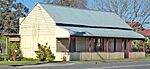
Former Post Office, 1835 -
Appin Public School, 1867 -
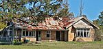
Derelict Appin Inn, 1826 -
Colonial era stone building
in main street -
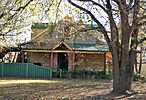
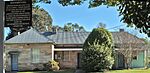
Former Anglican Rectory, 1843 -
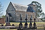
St Bede's Catholic Church, 1837-43 -
St Mark the Evangelist
Anglican Church, 1843 -

Darcy's Corner, c. 1955. -
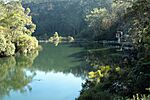
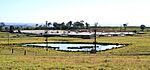
Broughton's Pass Weir -
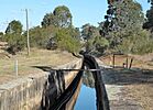
Upper Canal
west of Appin -
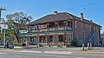
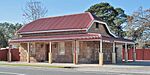
Appin Hotel -
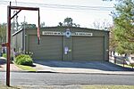
Rural Fire Brigade Shed -
Entrance, Appin Colliery -
Methane Gas Power Plant -
Inghams Broilers factory farm -
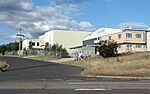
Industrial Area, south of town


