Arab, Alabama facts for kids
Quick facts for kids
Arab, Alabama
|
||
|---|---|---|

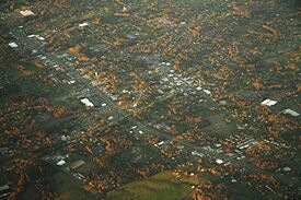
Aerial view of Arab
|
||
|
||
| Motto(s):
"Proud of our past... embracing the future"
|
||

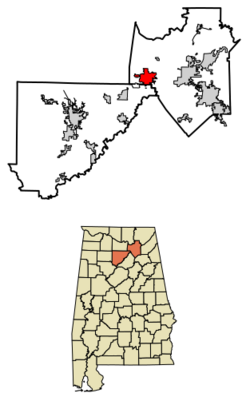
Location in Marshall and Cullman counties, Alabama
|
||
| Country | United States | |
| State | Alabama | |
| Counties | Marshall, Cullman | |
| Incorporated | December 10, 1892 | |
| Named for | Arad Thompson | |
| Government | ||
| • Type | Mayor–Council | |
| Area | ||
| • Total | 13.453 sq mi (34.843 km2) | |
| • Land | 13.320 sq mi (34.499 km2) | |
| • Water | 0.133 sq mi (34.454 km2) | |
| Elevation | 1,040 ft (317 m) | |
| Population
(2020)
|
||
| • Total | 8,461 | |
| • Estimate
(2022)
|
8,623 | |
| • Density | 647/sq mi (249.9/km2) | |
| Time zone | UTC−6 (Central (CST)) | |
| • Summer (DST) | UTC−5 (CDT) | |
| ZIP Code |
35016
|
|
| Area code(s) | 256 and 938 | |
| FIPS code | 01-02116 | |
| GNIS feature ID | 2403104 | |
| Sales tax | 12.5% | |
Arab (pronounced 'AIR-ab') is a city located in northern Alabama, USA. Most of the city is in Marshall County, with a small part in Cullman County. It's about 10 miles from Guntersville Lake and Guntersville Dam. Arab is part of the larger Huntsville-Decatur Combined Statistical Area. In 2020, about 8,461 people lived there.
Contents
History
What we know today as Arab started in the 1840s. It was founded by Stephen Tuttle Thompson and was first called "Thompson's Village."
The city got its unique name by accident! In 1882, Stephen's son, Arad Thompson, applied for a post office. He sent three names for the Postal Service to choose from: "Ink," "Bird," and "Arad." The Postal Service accidentally misspelled "Arad" as "Arab," and the name stuck. Because of this, Arab is often mentioned on lists of places with unusual names.
Arab officially became an incorporated city on December 10, 1892.
Geography
Arab is located high up on Brindlee Mountain, which is about 1,100 feet above sea level. This area is part of the Appalachian Plateau. The city is mainly in the southern part of Marshall County, but a small section reaches into Cullman County.
Two main roads pass through Arab:
- U.S. Route 231 runs north and south. It connects Arab to Huntsville (about 31 miles north) and Oneonta (about 32 miles south).
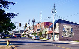
- State Route 69 runs east and west. It goes through the city's main business area. This road leads to Guntersville (about 13 miles east) and Cullman (about 23 miles southwest).
The city covers about 13.45 square miles, with most of it being land. Arab sits on a special place called the Tennessee Valley Divide. This means that rain falling on the north side of the city flows into creeks that lead to the Tennessee River. Water on the south side flows into the Mulberry Fork of the Black Warrior River, which is part of the Tombigbee River system.
Population Information
City of Arab Population Over Time
| Historical population | |||
|---|---|---|---|
| Census | Pop. | %± | |
| 1920 | 264 | — | |
| 1930 | 425 | 61.0% | |
| 1940 | 640 | 50.6% | |
| 1950 | 1,592 | 148.8% | |
| 1960 | 2,989 | 87.8% | |
| 1970 | 4,399 | 47.2% | |
| 1980 | 6,053 | 37.6% | |
| 1990 | 6,321 | 4.4% | |
| 2000 | 7,174 | 13.5% | |
| 2010 | 8,050 | 12.2% | |
| 2020 | 8,461 | 5.1% | |
| 2022 (est.) | 8,623 | 7.1% | |
| U.S. Decennial Census 2020 Census |
|||
Arab first started reporting its population in the U.S. Census in 1920. As you can see, the city has grown quite a bit since then!
2020 Census Data
In 2020, the city of Arab had 8,461 people living in 3,484 households. About 2,300 of these households were families. The city had about 635 people per square mile. There were also 3,739 housing units available.
Here's a look at the different groups of people living in Arab in 2020:
| Race | Number | Percent |
|---|---|---|
| White (non-Hispanic) | 7,630 | 90.18% |
| Black or African American (non-Hispanic) | 32 | 0.38% |
| Native American | 43 | 0.51% |
| Asian | 105 | 1.24% |
| Pacific Islander | 4 | 0.05% |
| Other/Mixed | 343 | 4.05% |
| Hispanic or Latino | 304 | 3.59% |
2010 Census Data
In 2010, Arab had 8,050 people living in 3,359 households. The average household had 2.37 people, and the average family had 2.92 people.
Here's a breakdown of the age groups in 2010:
- 23.7% were under 18 years old.
- 8.3% were between 18 and 24 years old.
- 22.0% were between 25 and 44 years old.
- 27.0% were between 45 and 64 years old.
- 19.1% were 65 years or older.
The median age in Arab was 42.2 years. This means half the people were younger than 42.2 and half were older.
The median income for a household was $42,435, and for a family it was $64,432. The average income per person in the city was $23,986. About 18.1% of the population lived below the poverty line.
City Services
Utilities
- Electricity: Arab Electric Cooperative provides electricity, getting its power from the Tennessee Valley Authority.
- Water: Arab Water Works supplies water, which comes from Browns Creek in Guntersville Lake.
- Natural Gas: Marshall County Gas District, based in Guntersville, provides natural gas.
Transportation
The main roads that help people travel in and out of Arab are:
Education
All students living in Arab attend schools within the Arab City School District, no matter which county they live in.
Notable People
Here are some well-known individuals who have connections to Arab:
- Liles C. Burke: A judge in the United States District Court for the Northern District of Alabama.
- Vernon Derrick: A talented fiddle and mandolin player.
- Fred Nall Hollis: A famous artist.
- Jill King: A singer and songwriter.
- Jack Lively: A pitcher who played in Major League Baseball.
- Wayne Mills: A country music singer.
See also
 In Spanish: Arab para niños


