Arlington (CDP), Vermont facts for kids
Quick facts for kids
Arlington, Vermont
|
|
|---|---|
| Country | United States |
| State | Vermont |
| County | Bennington |
| Towns | Arlington, Sunderland |
| Area | |
| • Total | 3.74 sq mi (9.68 km2) |
| • Land | 3.68 sq mi (9.53 km2) |
| • Water | 0.06 sq mi (0.15 km2) |
| Elevation | 646 ft (197 m) |
| Population
(2010)
|
|
| • Total | 1,213 |
| • Density | 330/sq mi (127.3/km2) |
| Time zone | UTC-5 (Eastern (EST)) |
| • Summer (DST) | UTC-4 (EDT) |
| ZIP code |
05250
|
| Area code(s) | 802 |
| FIPS code | 50-01375 |
| GNIS feature ID | 1460530 |
|
Arlington Village Historic District
|
|

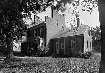
The Smith-Canfield House, a prominent house in the district
|
|
| Location | Roughly Main St., School St., E. Arlington Rd., and Battenkill Dr., Arlington, Vermont |
| Area | 180 acres (73 ha) |
| Architect | William Passman, et al. |
| Architectural style | Colonial Revival, Greek Revival, Federal |
| NRHP reference No. | 89001936 |
| Added to NRHP | November 02, 1989 |
Arlington is a small community in Vermont, United States. It is located in Bennington County. In 2010, about 1,213 people lived there.
Arlington is known for its Arlington Village Historic District. This special area was added to the National Register of Historic Places in 1989. It covers about 180 acres and includes 190 important old buildings and sites. These buildings show different styles of architecture, like Colonial Revival, Greek Revival, and Federal.
One famous building is the St. James Episcopal Church. It was built in 1829–30 and is one of the oldest Gothic Revival churches in Vermont. The village also has unique sidewalks made of marble from nearby quarries. In the early 1900s, Arlington was an important place for factories and mills. However, many of these were destroyed by a big flood in 1927.
Contents
Exploring Arlington's Location
The Arlington community includes the main village of Arlington. It also stretches east to include the area called East Arlington. This part even goes a little into the town of Sunderland.
Arlington village sits on the south side of the Batten Kill river. It is in a valley with the Taconic Mountains to the west. To the east, you can see the Green Mountains.
Main Roads in Arlington
Vermont Route 7A is the main road that goes through the village. It heads north towards Manchester. If you go south, it leads to Bennington.
Another important road is Vermont Route 313. This road goes west from the village center. It takes you to West Arlington and then to the New York state line. U.S. Route 7 goes around the village to the east. You can get to it from VT 313, just south of the village.
The total area of the Arlington community is about 3.7 square miles. All of this area is land.
People Who Live in Arlington
In 2000, there were 1,199 people living in Arlington. There were 516 households, which are groups of people living together. About 327 of these were families.
Most of the people in Arlington were White (about 97%). A small number were Black, Native American, or Asian. Some people were also from two or more races.
About 26% of households had children under 18 living with them. Nearly half of the households (about 50%) were married couples. About 15% of households had someone living alone who was 65 years old or older.
The average age of people in Arlington was 41 years old. About 22% of the population was under 18. About 17% of the population was 65 or older.
See also
 In Spanish: Arlington (condado de Bennington) para niños
 | Isaac Myers |
 | D. Hamilton Jackson |
 | A. Philip Randolph |


