Sunderland, Vermont facts for kids
Quick facts for kids
Sunderland, Vermont
|
|
|---|---|

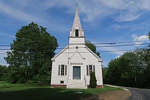
Sunderland Union Church
|
|

Sunderland, Vermont
|
|
| Country | United States |
| State | Vermont |
| County | Bennington |
| Communities | Sunderland Chiselville East Kansas Kansas |
| Area | |
| • Total | 45.6 sq mi (118.2 km2) |
| • Land | 45.3 sq mi (117.4 km2) |
| • Water | 0.3 sq mi (0.8 km2) |
| Elevation | 2,382 ft (726 m) |
| Population
(2020)
|
|
| • Total | 1,056 |
| • Density | 23/sq mi (9.0/km2) |
| Time zone | UTC-5 (Eastern (EST)) |
| • Summer (DST) | UTC-4 (EDT) |
| ZIP codes | |
| Area code(s) | 802 |
| FIPS code | 50-71425 |
| GNIS feature ID | 1462223 |
Sunderland is a small town in Bennington County, Vermont, United States. In 2020, about 1,056 people lived there. Sunderland is known for being home to Orvis, a company that sells outdoor gear and clothing.
Contents
Geography of Sunderland
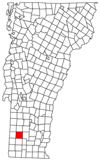
Sunderland is located in the eastern part of Bennington County, Vermont. It is about halfway between the northern and southern ends of the county. To the north, Sunderland borders the town of Manchester. To the west, it borders Arlington. The town of Glastenbury is to the south, and Stratton in Windham County is to the east.
Land and Water Features
The town covers a total area of about 118.2 square kilometers (45.6 square miles). Most of this area, about 117.4 square kilometers (45.3 square miles), is land. Only a small part, about 0.8 square kilometers (0.3 square miles), is water.
Most of Sunderland is covered by the Green Mountains. These mountains have a flat top, called a plateau, and steep western slopes, known as an escarpment. The western edge of the town is part of the Valley of Vermont.
Rivers and Trails
Most of the water in Sunderland flows westward into the Batten Kill river. The Batten Kill is a smaller river that eventually flows into the Hudson River. However, the southeastern part of the town drains south into the Glastenbury River. This river then joins the Deerfield River, which flows into the Connecticut River.
Major roads like U.S. Route 7 and Vermont Route 7A run through the western side of Sunderland. Vermont Route 313 is also a short road in this area. For hikers, the famous Long Trail and Appalachian Trail pass through the southeastern part of the town. These trails are near the top of the Green Mountains.
Population Changes in Sunderland
| Historical population | |||
|---|---|---|---|
| Census | Pop. | %± | |
| 1790 | 414 | — | |
| 1800 | 557 | 34.5% | |
| 1810 | 576 | 3.4% | |
| 1820 | 496 | −13.9% | |
| 1830 | 463 | −6.7% | |
| 1840 | 437 | −5.6% | |
| 1850 | 479 | 9.6% | |
| 1860 | 567 | 18.4% | |
| 1870 | 553 | −2.5% | |
| 1880 | 655 | 18.4% | |
| 1890 | 633 | −3.4% | |
| 1900 | 518 | −18.2% | |
| 1910 | 494 | −4.6% | |
| 1920 | 409 | −17.2% | |
| 1930 | 375 | −8.3% | |
| 1940 | 442 | 17.9% | |
| 1950 | 493 | 11.5% | |
| 1960 | 566 | 14.8% | |
| 1970 | 601 | 6.2% | |
| 1980 | 768 | 27.8% | |
| 1990 | 872 | 13.5% | |
| 2000 | 850 | −2.5% | |
| 2010 | 956 | 12.5% | |
| 2020 | 1,056 | 10.5% | |
| U.S. Decennial Census | |||
The population of Sunderland has changed over many years. In 1790, there were 414 people living in the town. By 1950, the population had grown to 493. The most recent count in 2020 showed that 1,056 people lived in Sunderland.
Notable People from Sunderland
- Frances "Fanny" Allen (1784–1819) was the first woman born in New England to become a nun.
- John W. Brownson was a state congressman and senator from New York.
- Jeremiah Evarts was a missionary and activist. He was against the Indian Removal Act of 1830.
- Lucy Terry, an African American poet and writer, lived and died in Sunderland.
See also
 In Spanish: Sunderland (Vermont) para niños
 | Roy Wilkins |
 | John Lewis |
 | Linda Carol Brown |


