
Artarmon facts for kids
Quick facts for kids ArtarmonSydney, New South Wales |
|||||||||||||||
|---|---|---|---|---|---|---|---|---|---|---|---|---|---|---|---|

Elizabeth Street
|
|||||||||||||||
| Established | 1794 | ||||||||||||||
| Postcode(s) | 2064 | ||||||||||||||
| Elevation | 88 m (289 ft) | ||||||||||||||
| Area | 2.5 km2 (1.0 sq mi) | ||||||||||||||
| Location | 9 km (6 mi) north of Sydney CBD | ||||||||||||||
| LGA(s) | City of Willoughby | ||||||||||||||
| State electorate(s) | Willoughby | ||||||||||||||
| Federal Division(s) | Bradfield | ||||||||||||||
|
|||||||||||||||

Artarmon is a suburb on the lower North Shore of Sydney, Australia. It is located 9 kilometres north-west of the main city centre of Sydney and is part of the City of Willoughby local government area.
Contents
History of Artarmon
Early Days
The story of Artarmon began a long time ago. In 1794 and 1796, the government gave land to soldiers and former convicts (called emancipists) to start farms.
One of the most important farms belonged to William Gore. He was the provost marshal, which was like a chief of police, for Governor William Bligh. In 1810, Gore was granted 150 acres (0.61 km2) of land. He named it Artarmon, after his family's home in Ireland. The nearby area of Gore Hill is also named after him.
Famous Old Buildings
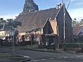
The Chatswood South Uniting Church is a historic building in Artarmon. It was designed by architect Thomas Rowe and built in 1871. It's a beautiful sandstone church in the Gothic style, with a small bell tower. Next to it is a small cemetery with graves dating back to 1871. This cemetery is now a protected park called the Pioneer's Memorial Reserve.
The Artarmon Post Office first opened on December 1, 1909. It served the community for over a century before it closed permanently on March 12, 2025.
Becoming a Suburb
After 1918, Artarmon began to change from farmland into a suburb. More people moved in, building smaller homes. They liked living there because it was close to the city but still had a lot of trees and parks.
After World War II, many more people moved to Sydney, and Artarmon grew even more. The suburb became more crowded, and factories and businesses started to open up. By the end of the 20th century, Artarmon had become a busy mix of homes, shops, and industries.
The Seven Network, a major TV channel, had its main office in Artarmon from 1999 to 2016. Today, that area has modern buildings with apartments and shops.
Heritage Listings
Artarmon has special sites that are protected because of their importance to history. These are called heritage-listed sites.
- 559 Pacific Highway: Chatswood Reservoirs No. 1 and No. 2
People Who Live in Artarmon
According to the 2021 census, 9,417 people lived in Artarmon.
About 47% of the people living in Artarmon were born in Australia. Many residents were born in other countries, including China (10.3%), India (7.4%), Hong Kong (3.2%), England (3.0%), and Japan (2.0%).
Just over half of the people spoke only English at home. Other languages spoken include Mandarin, Cantonese, Hindi, Japanese, and Nepali.
When asked about religion, the most common answer was "no religion" (42.4%). The next largest groups were Catholic (15.8%) and Anglican (8.8%).
The typical family in Artarmon earned about $2,420 per week, which was much higher than the average for all of Australia ($1,829).
Shops and Businesses
Artarmon is a place with a mix of everything. You can find tall apartment buildings, especially west of the train line, and regular houses to the east.
There is also an industrial area with factories and businesses south of the Gore Hill Freeway. Even with all this, the suburb has many trees and feels green.
Next to the train station on Hampden Road, there is a long street of shops. You can also find several restaurants in Wilkes Avenue, on the other side of the station. The Artarmon Public Library is a branch of the City of Willoughby library system.
TV and Media
Artarmon is a hub for Australian television.
- The Special Broadcasting Service (SBS), a public TV station, has its studios on Herbert Street.
- Fox Sports has its main office on Broadcast Way.
- A very tall tower in Hampden Road is used by the Seven Network and Network 10 to broadcast their TV signals.
- Until 2003, the Australian Broadcasting Corporation (ABC) was located nearby at Gore Hill.
- The Nine Network had its studios in the next suburb, Willoughby.
Getting Around
Artarmon railway station is on the North Shore railway line, which is part of the Sydney Trains network. This makes it easy to travel by train.
The Gore Hill Freeway connects with the Pacific Highway at Artarmon, so it's also easy to get around by car. Buses to the Sydney city centre also run along the Pacific Highway.
Schools
Artarmon Public School opened in 1910. It is a primary school known for being one of the top schools in the state for academic results. It is also one of the few schools with two Opportunity Classes (OC), which are special classes for gifted and talented students in Years 5 and 6. In 2018, it was ranked as the number one primary school. Starting in 2025, the number of places in the Opportunity Classes was reduced from 60 to 30.
Places of Worship
- St Basil's Artarmon Anglican Church www.artarmonchurch.org
- Artarmon Islamic Mosjid
Notable Residents
The famous photographer Max Dupain had his studio in Artarmon from 1971 until he passed away in 1992.
-
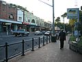
Hampden Road, looking north from the railway station
-
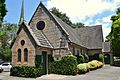
The heritage-listed Chatswood South Uniting Church
-
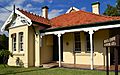
An old cottage from the Federation era, now used as a medical centre on Mowbray Road
-
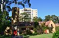
St Basil's Anglican Church on Broughton Road
-
Artarmon Library


Medical_Centre_Mowbray_Road.jpg)
St_Basils_Church_Broughton_Road.jpg)

