Semer, Suffolk facts for kids
Quick facts for kids Semer |
|
|---|---|
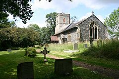
 All Saints Church |
|
| Population | 130 (population of the whole parish in 2011) |
| District |
|
| Shire county | |
| Region | |
| Country | England |
| Sovereign state | United Kingdom |
| Post town | Ipswich |
| Postcode district | IP7 |
| EU Parliament | East of England |
| UK Parliament |
|
Semer is a small village in Suffolk, England. It is located near a bridge over the River Brett, between the towns of Hadleigh and Stowmarket. Semer is part of the Babergh area. This village also includes two tiny settlements called Ash Street and Drakestone Green.
In 2011, about 130 people lived in Semer. This was a bit less than the 158 people who lived there in an earlier count.
Contents
A Look Back: Semer's History
Semer is mentioned in the Domesday Book, a famous survey from 1086. This book shows that Bury St Edmunds Abbey owned Semer in both 1066 and 1086. The Abbey was like the main boss of the land.
The Domesday Book also tells us about the village itself. It had 20 homes, including six villagers, 13 small farmers, and one slave. There was enough land for farms, plus 12 acres of meadow. The village also had a mill, a church, and land for the church. They kept 16 cattle, 2 horses, 24 pigs, and 97 sheep.
In 1086, Semer was worth £6 a year to the Abbey. This was £1 more than its value in 1066.
All Saints Church: A Historic Building
The small All Saints Church in Semer is found a short distance from the main road. It sits across a field, right next to the River Brett. The church was mostly rebuilt in 1870, especially the chancel part.
In the churchyard, to the east of the church, you can see a special marble angel statue. This angel, from the Edwardian era, looks like it is scattering roses. Inside the church, there is a simple, square font. Experts believe this font is from the 14th century, just like the main part of the church, called the nave. You can also see a painting of the Royal Arms of King George III. This painting was made before Ireland joined with Great Britain. The church has been a Grade II listed building since 1980, meaning it is an important historic place.
Small Settlements: Hamlets of Semer
The Semer area includes two smaller settlements, known as hamlets.
Ash Street
Ash Street is a small hamlet located about 0.5 miles (0.8 km) east of Semer church. It is found north of a bridge over the River Brett.
The Domesday Book also mentions Ash Street. It was a very tiny settlement with only five small farmers. It had 6 acres (2.4 ha) of meadow and a mill. Before the Norman Conquest in 1066, a "Free Woman" owned Ash Street. After the Conquest, William the Conqueror's half-brother, Robert, Count of Mortain, became its owner.
Drakestone Green
Drakestone Green is another small hamlet. It is located about 1 mile (1.6 km) south of Semer church.
 | Laphonza Butler |
 | Daisy Bates |
 | Elizabeth Piper Ensley |


