Ash Township, Michigan facts for kids
Quick facts for kids
Ash Township, Michigan
|
|
|---|---|

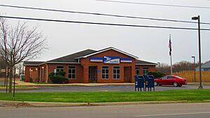
Ash Township Hall and Fire Department
|
|

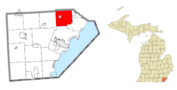
Location within Monroe County (red) and the administered village of Carleton (pink)
|
|
| Country | United States |
| State | Michigan |
| County | Monroe |
| Organized | 1837 |
| Area | |
| • Total | 34.84 sq mi (90.24 km2) |
| • Land | 34.60 sq mi (89.61 km2) |
| • Water | 0.24 sq mi (0.62 km2) |
| Elevation | 604 ft (184 m) |
| Population
(2020)
|
|
| • Total | 7,860 |
| • Density | 227.1/sq mi (87.7/km2) |
| Time zone | UTC-5 (Eastern (EST)) |
| • Summer (DST) | UTC-4 (EDT) |
| ZIP Codes | |
| Area code(s) | 734 |
| FIPS code | 26-115-03680 |
| GNIS feature ID | 1625853 |

Ash Township is a community located in Monroe County, Michigan, in the United States. It is a type of local government area called a civil township. As of the 2020 census, about 7,860 people live in Ash Township.
Contents
History of Ash Township
Ash Township was officially created in 1837. It was formed from the northern part of another area called Frenchtown Township. The township got its name from a local resident named Arba Ash. He suggested the name during one of the first meetings for the township.
Historic Sites in Ash Township
Potter Cemetery is a very old cemetery. It is located in the eastern part of Ash Township.
Communities in Ash Township
Ash Township has several communities, including some that no longer exist.
- Althone was a settlement in the township. It was started by German Catholic families. Althone had its own post office for a short time in the 1850s. It then reopened and operated for a longer period until 1894.
- Briar Hill was another settlement that started in 1897. It was located along a train station. You can see Briar Hill on old maps of Monroe County from 1911.
- Carleton is a village located in the west-central part of the township.
- Clark City was a settlement built around a mill that made wooden staves. A stave is a narrow piece of wood used to make barrels. Clark City also had its own post office from 1855 to 1866.
- Grafton is an unincorporated community in the township. This means it's a recognized place but doesn't have its own separate local government. Grafton is located along a railway line and had a post office from 1850 to 1903.
Geography of Ash Township
Ash Township is in the northeastern part of Monroe County. Its northern border is also the line for Wayne County. The township covers about 34.84 square miles (90.24 square kilometers). Most of this area is land, with a small part being water.
Waterways in Ash Township
Most of the township's water drains into Swan Creek and its smaller streams. The northeast part of the township drains into Port Creek, which flows into the Huron River. The southwest part drains into Stony Creek. Swan Creek, Stony Creek, and the Huron River all flow southeast into Lake Erie.
Transportation in Ash Township
Getting around Ash Township is easy with its airport and major highways.
Airport Access
 Buzzwick Airport is a public airport. It is located in the southern part of the township.
Major Highways
 I-275 is a major highway that runs north and south through the middle of the township. It has three exits within Ash Township.
 US 24 (Telegraph Road) is another important highway. It runs diagonally through the southeastern part of the township.
Education in Ash Township
Students in Ash Township attend schools in different school districts.
- Most of the township is served by Airport Community Schools.
- Some small areas in the northern part of the township are part of the Huron School District. This district is located in Huron Township in Wayne County.
- A very small part of the northeastern township is served by Flat Rock Community Schools. This district is in Flat Rock, also in Wayne County.
Population and People
| Historical population | |||
|---|---|---|---|
| Census | Pop. | %± | |
| 1850 | 1,229 | — | |
| 1860 | 2,124 | 72.8% | |
| 1870 | 1,451 | −31.7% | |
| 1880 | 2,252 | 55.2% | |
| 1890 | 1,997 | −11.3% | |
| 1900 | 1,913 | −4.2% | |
| 1910 | 1,840 | −3.8% | |
| 1920 | 1,735 | −5.7% | |
| 1930 | 2,433 | 40.2% | |
| 1940 | 2,679 | 10.1% | |
| 1950 | 3,345 | 24.9% | |
| 1960 | 4,825 | 44.2% | |
| 1970 | 5,803 | 20.3% | |
| 1980 | 7,688 | 32.5% | |
| 1990 | 7,480 | −2.7% | |
| 2000 | 7,610 | 1.7% | |
| 2010 | 7,783 | 2.3% | |
| 2020 | 7,860 | 1.0% | |
| U.S. Decennial Census | |||
In 2000, there were 7,610 people living in Ash Township. These people lived in 2,801 households. About 2,125 of these households were families. The average household had 2.72 people. The average family had 3.13 people.
Age Distribution
The population of Ash Township includes people of all ages.
- About 27.5% of the people were under 18 years old.
- Around 8.3% were between 18 and 24 years old.
- About 29.4% were between 25 and 44 years old.
- Around 24.5% were between 45 and 64 years old.
- About 10.1% were 65 years old or older.
The median age in the township was 36 years. This means half the people were younger than 36 and half were older.
Income Information
In 2000, the average income for a household in Ash Township was $54,439. For families, the average income was $61,020. The average income per person in the township was $24,271.
Notable People
- James DeSana is a politician. He serves in the Michigan House of Representatives. James DeSana lives in Ash Township.
See also
 In Spanish: Municipio de Ash (Míchigan) para niños


