
Ashland, Alabama facts for kids
Quick facts for kids
Ashland, Alabama
|
|
|---|---|
|
City
|
|

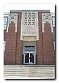
The Clay County Courthouse is located in Ashland. The Classical Revival-style building has served as the county courthouse since its completion in 1906.
|
|

Location of Ashland in Clay County, Alabama.
|
|

Ashland, Alabama
Location in Alabama

Ashland, Alabama
Location in the United States

Ashland, Alabama
Location in North America
|
|
| Country | United States |
| State | Alabama |
| County | Clay |
| Settled | 1867 |
| Incorporated | 1871 |
| Named for | Henry Clay's estate |
| Government | |
| • Type | Mayor/City Council |
| Area | |
| • Total | 7.38 sq mi (19.11 km2) |
| • Land | 7.35 sq mi (19.03 km2) |
| • Water | 0.03 sq mi (0.09 km2) |
| Elevation | 1,119 ft (341 m) |
| Population
(2020)
|
|
| • Total | 1,984 |
| • Density | 270.08/sq mi (104.28/km2) |
| Time zone | UTC-6 (Central (CST)) |
| • Summer (DST) | UTC-5 (CDT) |
| ZIP code |
36251
|
| Area code(s) | 256 |
| FIPS code | 01-02860 |
| GNIS feature ID | 0159091 |
| Website | http://www.cityofashland.net/ |
Ashland is a city in Clay County, Alabama, United States. It is the main town, also known as the county seat, of Clay County. In 2020, about 1,984 people lived there.
Contents
History of Ashland
Clay County was officially created in Alabama on December 7, 1866. Less than a year later, in 1867, Ashland was chosen as the county seat. This happened on land given by Hollingsworth Watts for a new courthouse.
In 1871, Ashland became an official town. It was named after the famous 19th-century statesman Henry Clay's home in Kentucky.
Early Growth and Industry Changes
The town grew very quickly in its early years. This growth continued when Alabama's first graphite mine opened in Ashland in 1899. Graphite is a material used in pencils and batteries.
However, when World War I ended, the demand for graphite dropped a lot. This caused the town's fast growth to slow down.
The 1930s brought tough times with the Great Depression. A tiny insect called the boll weevil also caused big problems for cotton farms. Farmers had to stop growing cotton, which was the main industry. By the early 2000s, new industries like timber (wood), poultry (chickens), and making cabinets became important for Ashland.
Geography of Ashland
Ashland is located at 33°16′20″N 85°50′13″W / 33.27222°N 85.83694°W.
Roads and Location
Two main roads, AL-9 and AL-77, pass through Ashland. AL-9 goes through the center of town. It leads northeast about 6 miles (10 km) to Lineville. It also goes southwest about 20 miles (32 km) to Goodwater.
AL-77 meets AL-9 in downtown Ashland. It goes northwest about 24 miles (39 km) to Talladega. It also heads southeast about 21 miles (34 km) to Wadley.
Area and Elevation
The city covers a total area of about 7.3 square miles (19 square kilometers). Most of this area, about 7.2 square miles (19 square kilometers), is land. Only a small part, about 0.04 square miles (0.10 square kilometers), is water.
Ashland is also special because it is Alabama's highest county seat. It sits at about 1,130 feet (344 meters) above sea level.
Ashland's Climate
The weather in Ashland has hot, humid summers. Winters are usually mild to cool. This type of weather is called a humid subtropical climate. On climate maps, it is shown as "Cfa".
| Climate data for Ashland, Alabama (1991–2020 normals, extremes 1957–2013) | |||||||||||||
|---|---|---|---|---|---|---|---|---|---|---|---|---|---|
| Month | Jan | Feb | Mar | Apr | May | Jun | Jul | Aug | Sep | Oct | Nov | Dec | Year |
| Record high °F (°C) | 77 (25) |
80 (27) |
88 (31) |
91 (33) |
94 (34) |
102 (39) |
106 (41) |
103 (39) |
97 (36) |
91 (33) |
85 (29) |
78 (26) |
106 (41) |
| Mean maximum °F (°C) | 70.3 (21.3) |
74.0 (23.3) |
80.6 (27.0) |
84.7 (29.3) |
88.1 (31.2) |
92.7 (33.7) |
95.1 (35.1) |
94.7 (34.8) |
90.9 (32.7) |
85.3 (29.6) |
78.5 (25.8) |
70.9 (21.6) |
96.5 (35.8) |
| Mean daily maximum °F (°C) | 54.9 (12.7) |
59.0 (15.0) |
66.9 (19.4) |
74.4 (23.6) |
80.8 (27.1) |
87.2 (30.7) |
89.8 (32.1) |
88.9 (31.6) |
84.3 (29.1) |
75.8 (24.3) |
65.5 (18.6) |
57.1 (13.9) |
73.7 (23.2) |
| Daily mean °F (°C) | 43.0 (6.1) |
46.4 (8.0) |
53.2 (11.8) |
60.5 (15.8) |
68.0 (20.0) |
75.0 (23.9) |
78.3 (25.7) |
77.5 (25.3) |
72.1 (22.3) |
62.3 (16.8) |
51.9 (11.1) |
45.1 (7.3) |
61.1 (16.2) |
| Mean daily minimum °F (°C) | 31.1 (−0.5) |
33.8 (1.0) |
39.5 (4.2) |
46.6 (8.1) |
55.2 (12.9) |
62.8 (17.1) |
66.8 (19.3) |
66.0 (18.9) |
59.9 (15.5) |
48.7 (9.3) |
38.3 (3.5) |
33.2 (0.7) |
48.5 (9.2) |
| Mean minimum °F (°C) | 13.0 (−10.6) |
17.8 (−7.9) |
23.5 (−4.7) |
30.4 (−0.9) |
40.9 (4.9) |
52.2 (11.2) |
59.7 (15.4) |
58.4 (14.7) |
45.6 (7.6) |
31.9 (−0.1) |
24.5 (−4.2) |
15.8 (−9.0) |
9.4 (−12.6) |
| Record low °F (°C) | −7 (−22) |
1 (−17) |
8 (−13) |
23 (−5) |
33 (1) |
42 (6) |
51 (11) |
51 (11) |
34 (1) |
26 (−3) |
11 (−12) |
1 (−17) |
−7 (−22) |
| Average precipitation inches (mm) | 6.09 (155) |
6.02 (153) |
6.03 (153) |
4.67 (119) |
4.64 (118) |
4.63 (118) |
4.75 (121) |
5.11 (130) |
3.50 (89) |
3.77 (96) |
4.85 (123) |
5.64 (143) |
59.70 (1,516) |
| Average snowfall inches (cm) | 0.3 (0.76) |
0.2 (0.51) |
0.6 (1.5) |
0.0 (0.0) |
0.0 (0.0) |
0.0 (0.0) |
0.0 (0.0) |
0.0 (0.0) |
0.0 (0.0) |
0.0 (0.0) |
0.0 (0.0) |
0.5 (1.3) |
1.6 (4.1) |
| Average precipitation days (≥ 0.01 in) | 11.3 | 10.4 | 10.6 | 9.5 | 9.5 | 11.5 | 12.5 | 10.8 | 8.3 | 7.7 | 8.7 | 10.5 | 121.3 |
| Average snowy days (≥ 0.1 in) | 0.3 | 0.2 | 0.2 | 0.0 | 0.0 | 0.0 | 0.0 | 0.0 | 0.0 | 0.0 | 0.0 | 0.3 | 1.0 |
| Source: NOAA (mean maxima/minima 1981–2010) | |||||||||||||
Ashland's Population Data
| Historical population | |||
|---|---|---|---|
| Census | Pop. | %± | |
| 1870 | 118 | — | |
| 1880 | 387 | 228.0% | |
| 1890 | 635 | 64.1% | |
| 1900 | 422 | −33.5% | |
| 1910 | 1,062 | 151.7% | |
| 1920 | 1,655 | 55.8% | |
| 1930 | 1,476 | −10.8% | |
| 1940 | 1,608 | 8.9% | |
| 1950 | 1,593 | −0.9% | |
| 1960 | 1,610 | 1.1% | |
| 1970 | 1,921 | 19.3% | |
| 1980 | 2,052 | 6.8% | |
| 1990 | 2,034 | −0.9% | |
| 2000 | 1,965 | −3.4% | |
| 2010 | 2,037 | 3.7% | |
| 2020 | 1,984 | −2.6% | |
| U.S. Decennial Census | |||
Ashland first appeared in the U.S. Census in 1870 as a small village. It officially became a town the next year. From 1870 to 1950, Ashland was the largest community in Clay County. However, in 1960, Lineville became slightly larger.
2010 Census Information
In 2010, Ashland had 2,037 people living in 849 households. About 516 of these were families. The city had about 273 people per square mile.
Most residents were White (71.5%) or Black/African American (24.1%). About 5.7% of the population was Hispanic or Latino.
About 26% of households had children under 18. Many households (37.3%) were married couples. About 37.2% of all households were individuals living alone. Almost 19% of households had someone aged 65 or older living alone.
The average age in Ashland was 41.8 years. For every 100 females, there were about 84.8 males.
2020 Census Information
| Race | Num. | Perc. |
|---|---|---|
| White (non-Hispanic) | 1,309 | 65.98% |
| Black or African American (non-Hispanic) | 503 | 25.35% |
| Native American | 3 | 0.15% |
| Asian | 25 | 1.26% |
| Pacific Islander | 1 | 0.05% |
| Other/Mixed | 77 | 3.88% |
| Hispanic or Latino | 66 | 3.33% |
As of the 2020 United States census, Ashland had 1,984 people. There were 677 households and 333 families living in the town.
Education in Ashland
The main schools for the area, Central High School of Clay County and Central Junior High School, are located in Lineville.
Clay County High School has won several state championships in sports.
- Football: 1994, 1995, 1996, 2000, 2005
- Boys basketball: 1991, 1992
The school also won the 1-A State Football Championship in 2002.
Media
Ashland has a few local radio stations:
- WCKF 100.7 FM (plays Classic Country music)
- WFAZ 90.9 FM (also plays Classic Country music)
Notable People from Ashland
Many well-known people have connections to Ashland:
- Howard Ballard: A former player in the NFL.
- Hugo Black: He was a Justice on the highest court in the U.S. from 1937 to 1971. His first law office was in Ashland.
- Hiram Wesley Evans: He was a leader of the Ku Klux Klan from 1922 to 1939.
- Bob Riley: He served as Alabama's 52nd governor.
- Jack L. Treadwell: A United States Army colonel who received the Medal of Honor for his bravery.
Gallery
-
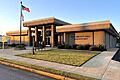
Ashland City Hall and Water Department
-
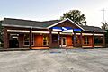
Ashland Post Office (ZIP code: 36251)
-
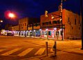
Downtown Ashland at dusk.
-
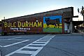
A Bull Durham mural in Downtown Ashland.
-
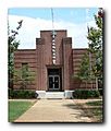
Ashland Elementary School.
-
The former Clay County High School building in Ashland.


See Also
 in Spanish!") In Spanish: Ashland (Alabama) para niños
In Spanish: Ashland (Alabama) para niños
