
Ashville, Alabama facts for kids
Quick facts for kids
Ashville, Alabama
|
|||
|---|---|---|---|

St. Clair County Courthouse in Ashville
|
|||
|
|||

Location of Ashville in St. Clair County, Alabama.
|
|||

Ashville, Alabama
Location in Alabama

Ashville, Alabama
Location in the United States

Ashville, Alabama
Location in North America
|
|||
| Country | United States | ||
| State | Alabama | ||
| County | St. Clair | ||
| Area | |||
| • Total | 19.40 sq mi (50.25 km2) | ||
| • Land | 19.21 sq mi (49.76 km2) | ||
| • Water | 0.19 sq mi (0.49 km2) | ||
| Elevation | 577 ft (176 m) | ||
| Population
(2020)
|
|||
| • Total | 2,346 | ||
| • Density | 122.10/sq mi (47.14/km2) | ||
| Time zone | UTC-6 (Central (CST)) | ||
| • Summer (DST) | UTC-5 (CDT) | ||
| ZIP code |
35953
|
||
| Area codes | 205, 659 | ||
| FIPS code | 01-02908 | ||
| GNIS feature ID | 0164539 | ||


Ashville is a city in Alabama, United States. It is one of the two county seats of St. Clair County. A county seat is a main town where the local government offices are located. The other county seat is Pell City. In 2020, about 2,346 people lived in Ashville. The city officially became a town in 1822.
Contents
History of Ashville
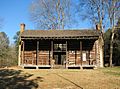
Ashville was first known as St. Clairsville. Its name was changed to honor John Ash, who was the first white settler in the area. He arrived in 1817. John Ash became the first county judge and later a state senator. His old log cabin can still be seen in the city center today.
The land where Ashville stands was originally owned by Philip Coleman. He sold 30 acres to five county commissioners, including John Ash. These commissioners were chosen by Governor Thomas Bibb to set up a new county seat for St. Clair. Ashville was chosen as the county seat in 1821 and became an official village in 1822. The first courthouse, also a log building, was built two years later. A new courthouse, which is still standing, replaced it in 1844.
In 1890, a group of investors tried to build a railroad line. This line would connect Sheffield to Anniston, passing through Ashville. They managed to build tracks from Whitney to Ashville. This connected Ashville to the Alabama Great Southern Railroad. However, the company went out of business in the mid-1890s. The railroad tracks were then taken apart and sold.
Electric lights came to Ashville in 1891. The first telephone company also started in the same year. People living in the southern part of the county often found it hard to travel to Ashville. This was because Backbone Mountain divided the county. So, in 1907, the state government allowed a second county seat to be set up in Pell City. Pell City is on the southern side of the mountain.
Geography of Ashville
Ashville is located at 33°50′37″N 86°15′59″W / 33.84361°N 86.26639°W.
The city covers a total area of about 19.4 square miles (50.25 square kilometers). Most of this area, about 19.21 square miles (49.76 square kilometers), is land. The rest, about 0.19 square miles (0.49 square kilometers), is water.
Ashville's Climate
The weather in Ashville has hot, humid summers. The winters are usually mild to cool. This type of weather is called a humid subtropical climate.
| Climate data for Ashville, Alabama | |||||||||||||
|---|---|---|---|---|---|---|---|---|---|---|---|---|---|
| Month | Jan | Feb | Mar | Apr | May | Jun | Jul | Aug | Sep | Oct | Nov | Dec | Year |
| Mean daily maximum °C (°F) | 13 (55) |
13 (55) |
19 (66) |
23 (73) |
28 (83) |
32 (89) |
32 (90) |
32 (90) |
30 (86) |
24 (76) |
18 (64) |
12 (53) |
23 (73) |
| Mean daily minimum °C (°F) | 1 (33) |
1 (33) |
6 (43) |
9 (48) |
13 (56) |
18 (65) |
20 (68) |
19 (67) |
16 (60) |
9 (49) |
3 (38) |
1 (33) |
9 (49) |
| Average precipitation mm (inches) | 130 (5.3) |
140 (5.4) |
160 (6.4) |
120 (4.6) |
91 (3.6) |
94 (3.7) |
130 (5) |
99 (3.9) |
91 (3.6) |
66 (2.6) |
86 (3.4) |
130 (5.1) |
1,330 (52.5) |
| Source: Weatherbase | |||||||||||||
Ashville's Population
Ashville first appeared in the U.S. Census in 1860 as an official town. The population has changed over the years:
| Historical population | |||
|---|---|---|---|
| Census | Pop. | %± | |
| 1860 | 117 | — | |
| 1900 | 362 | — | |
| 1910 | 278 | −23.2% | |
| 1920 | 349 | 25.5% | |
| 1930 | 369 | 5.7% | |
| 1940 | 385 | 4.3% | |
| 1950 | 494 | 28.3% | |
| 1960 | 973 | 97.0% | |
| 1970 | 986 | 1.3% | |
| 1980 | 1,489 | 51.0% | |
| 1990 | 1,494 | 0.3% | |
| 2000 | 2,260 | 51.3% | |
| 2010 | 2,212 | −2.1% | |
| 2020 | 2,346 | 6.1% | |
| U.S. Decennial Census 2013 Estimate |
|||
2010 Census Information
According to the 2010 United States Census, there were 2,212 people living in Ashville. These people lived in 793 households, and 597 of these were families. The population density was about 114.6 people per square mile.
Most people living in Ashville were White (75.8%). About 20.3% were Black or African American. A small number of people were Native American (0.2%), Asian (0.3%), or from other backgrounds. About 3.8% of the population identified as Hispanic or Latino.
About 24% of the people were under 18 years old. About 13.3% were 65 years or older. The average age in Ashville was 37.3 years.
2020 Census Information
| Race | Num. | Perc. |
|---|---|---|
| White (non-Hispanic) | 1,654 | 70.5% |
| Black or African American (non-Hispanic) | 405 | 17.26% |
| Native American | 20 | 0.85% |
| Asian | 19 | 0.81% |
| Pacific Islander | 4 | 0.17% |
| Other/Mixed | 120 | 5.12% |
| Hispanic or Latino | 124 | 5.29% |
As of the 2020 United States census, Ashville had 2,346 people. There were 778 households and 584 families living in the city.
April 27, 2011, Tornado
On the evening of April 27, 2011, a very strong tornado hit the Shoal Creek Valley community. This community is just south of Ashville. The tornado was an EF-4, which means it was very powerful. Sadly, 13 people lost their lives.
The tornado also caused a lot of damage. It destroyed homes, farm animals, forests, and farm equipment. People from nearby communities quickly came to help. However, many roads were blocked by fallen trees. This made it hard for help to reach everyone right away. Some victims had to wait hours for aid to arrive.
After the disaster, the Governor of Alabama, Robert Bentley, visited the community. Officials from the Alabama Emergency Management Agency and the Federal Emergency Management Agency also came. The community received help from both the state and federal governments for several weeks.
Education in Ashville
Ashville is part of the St. Clair County School System. Here are the schools in Ashville:
- Ashville Elementary School
- Principal: Shane Parker
- Guidance Counselor: Summer Burke
- Ashville Middle School
- Principal: Rusty St. John
- Assistant Principal: TBA
- Guidance Counselor: Kerry Montgomery
- Ashville High School
- Principal: Janet Johnson
- Assistant Principal: TBA
- Guidance Counselor: TBA
- Mascot: Bulldogs
- School Colors: Kelly Green, White, and Orange
Notable People from Ashville
- Rufus W. Cobb: He was the Governor of Alabama from 1878 to 1882.
- John Grass: He graduated from Ashville High School in 1985. He is a head football coach for Jacksonville State University.
- Howard Hill: He was a famous archer from Hollywood. People called him "The World's Greatest Archer." He won 196 archery competitions. He also worked as a stunt double for the actor Errol Flynn. Howard Hill is buried in Ashville.
Images for kids
-

Court Street, Ashville
-
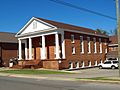
First Baptist Church, Ashville
-
St. Clair County Courthouse, Ashville
-
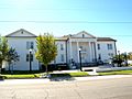
St. Clair County Courthouse, Ashville
-
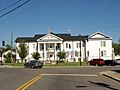
Inzer House, Ashville
-
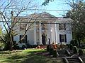
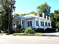
Dr. James J. Bothwell House, Ashville
-
Judge Elisha Robinson House, Ashville
-
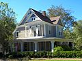
John Looney House, Ashville
-
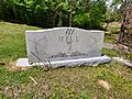
Howard Hill gravesite


See also
 In Spanish: Ashville (Alabama) para niños
