Atlanta, Michigan facts for kids
Quick facts for kids
Atlanta, Michigan
|
|
|---|---|
| Nickname(s):
Elk Capital of Michigan
|
|

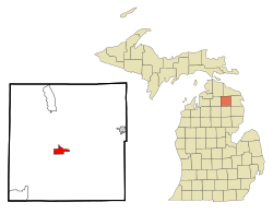
Location in Montmorency County and the state of Michigan
|
|
| Country | |
| State | |
| County | Montmorency |
| Townships | Briley, Avery |
| Established | 1881 |
| Area | |
| • Total | 3.78 sq mi (9.80 km2) |
| • Land | 3.61 sq mi (9.35 km2) |
| • Water | 0.17 sq mi (0.45 km2) |
| Elevation | 892 ft (272 m) |
| Population
(2020)
|
|
| • Total | 720 |
| • Density | 199.39/sq mi (76.98/km2) |
| Time zone | UTC-5 (Eastern (EST)) |
| • Summer (DST) | UTC-4 (EDT) |
| ZIP code |
49709
|
| Area code(s) | 989 |
| FIPS code | 26-03920 |
| GNIS feature ID | 0620305 |
Atlanta is a small community in Michigan, United States. It is the main town, also called the county seat, of Montmorency County. In 2020, about 720 people lived there. Atlanta is known as the "Elk Capital of Michigan" because many elk live nearby.
Atlanta also hosts the yearly Sno*Drift rally racing event. This exciting race is usually the first event of the Rally America National Rally Championship season.
Contents
History of Atlanta
Atlanta was started in 1881 by a person named Alfred J. West. The first post office opened on March 24, 1882, and was called "Big Rock." Later, on October 2, 1882, its name was changed to Atlanta. It was named after the city of Atlanta, Georgia.
Geography and Location
Atlanta is located in the middle of Montmorency County. Most of it is in Briley Township, with a small part extending into Avery Township.
It is about 46 miles (74 km) west of Alpena, which is on Lake Huron. Atlanta is also 32 miles (51 km) east of Gaylord and Interstate 75. If you go north, Onaway is about 26 miles (42 km) away.
The U.S. Census Bureau says that Atlanta covers a total area of about 3.8 square miles (9.8 square kilometers). Most of this area, about 3.6 square miles (9.3 square kilometers), is land. The rest, about 0.2 square miles (0.5 square kilometers), is water. The Thunder Bay River flows through the community. It enters from the southwest and leaves to the southeast, heading towards Thunder Bay on Lake Huron.
Main Roads in Atlanta
- M-32 is a road that goes east and west through Atlanta. You can use this highway to reach Gaylord to the west. To the east, it leads to Hillman and Alpena.
- M-33 is a road that goes north and south through Atlanta. This highway can take you to Mio in the south. To the north, it leads to Onaway and Cheboygan.
Climate in Atlanta
Atlanta has a humid continental climate. This means it has big changes in temperature throughout the year. Summers are warm to hot and often humid. Winters are cold, and sometimes very cold. On climate maps, this type of climate is often called "Dfb."
Population Facts
| Historical population | |||
|---|---|---|---|
| Census | Pop. | %± | |
| 2000 | 757 | — | |
| 2010 | 827 | 9.2% | |
| 2020 | 720 | −12.9% | |
| U.S. Decennial Census | |||
In 2000, there were 757 people living in Atlanta. These people lived in 339 households, and 215 of those were families. The average number of people in a household was 2.22. For families, the average was 2.73 people.
The median age in Atlanta was 43 years old. This means half the people were younger than 43, and half were older. About 22.1% of the population was under 18 years old. About 19.9% of the population was 65 years or older.
The median income for a household in 2000 was $23,529. For families, the median income was $37,188.
Education in Atlanta
Students in Atlanta attend schools that are part of the Atlanta Community Schools district.
See also
 In Spanish: Atlanta (Míchigan) para niños
 | Shirley Ann Jackson |
 | Garett Morgan |
 | J. Ernest Wilkins Jr. |
 | Elijah McCoy |

