Balclutha, New Zealand facts for kids
Quick facts for kids
Balclutha
Iwikatea (Māori)
|
|
|---|---|
|
Town
|
|

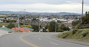
Looking across the Clutha towards the town centre. The distinctive road bridge is visible in the centre of the picture
|
|
| Country | New Zealand |
| Region | Otago |
| Territorial authority | Clutha District |
| Ward | Balclutha |
| Electorates |
|
| Area | |
| • Total | 7.55 km2 (2.92 sq mi) |
| Population
(June 2023)
|
|
| • Total | 4,340 |
| • Density | 574.8/km2 (1,488.8/sq mi) |
| Time zone | UTC+12 (NZST) |
| • Summer (DST) | UTC+13 (NZDT) |
| Postcode(s) |
9230
|
| Area code(s) | 03 |
| Local iwi | Ngāi Tahu |
Balclutha (which is Iwikatea in Māori) is a town in South Otago, New Zealand. It is located on the east coast of the South Island, near the end of the Clutha River. Balclutha is about halfway between the cities of Dunedin and Gore. You can reach it by State Highway 1 or the Southern Scenic Route.
With a population of about 4,340 people (as of June 2023), Balclutha is the biggest town in South Otago. The local government, the Clutha District Council, has its main office here. Balclutha is a key service center for the farms along the lower Clutha River. It is also close to the Catlins, a beautiful area with native forests, wildlife, and a rugged coastline.
Contents
History of Balclutha
Balclutha is often called "Clutha" by locals. Its name, and the name of the river it sits on, show its Scottish beginnings. The name comes from Scottish Gaelic and means "Town on the Clyde."
The town's founder, James McNeil, arrived in 1853 from Scotland. He started a farm where the town is now. In 1857, he and the government set up a ferry service across the Clutha River. Because of this, the town was first called Clutha Ferry. The Māori name for this area is Iwikatea.
Who Lives in Balclutha?
Balclutha covers about 7.55 square kilometers. As of June 2023, it has an estimated population of 4,340 people. This means there are about 575 people living in each square kilometer.
In the 2018 New Zealand census, Balclutha had 4,110 people. This was a small increase from 2013. There were more females than males living in the town. About 16.5% of the people were under 15 years old.
Most people in Balclutha (86.7%) are of European background. About 11.5% are Māori, and smaller groups are Pasifika and Asian. About 12.6% of the people were born outside New Zealand.
When asked about religion, many people (52.1%) said they had no religion. About 36.3% were Christian.
Landmarks and Natural Features
The Clutha River flows right through Balclutha. It is New Zealand's largest river by the amount of water it carries. The river is great for fun activities like fishing for brown trout, water skiing, and power boating. Just south of the town, the river splits into two smaller rivers: the Matau and the Koau.
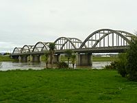
The most famous building in town is the Balclutha Road Bridge. This concrete bridge was built in 1935 and crosses the Clutha River. The first wooden bridge from 1868 was washed away in a flood in 1878. A new one was built in 1881, but it wasn't good enough for cars later on.
The main railway line for the South Island crosses the river about 800 meters downstream from the road bridge. Most of Balclutha is on flat land inside a big curve of the river. However, North Balclutha is on a hill to the north, and Rosebank is on a hill to the south.
There are also several natural sights nearby. These include Lake Tuakitoto near Benhar/Kaitangata. Matai Falls, a beautiful waterfall, is in the Catlins. You can also see yellow-eyed penguins coming ashore in the Balclutha area, and a place called The Nuggets is close by at Kaka Point.
Education in Balclutha
Balclutha has several schools for students of all ages.
Primary Schools
- Balclutha School is a state primary school for students in Year 1 to 8. It has about 196 students.
- Rosebank School is also a state primary school for Year 1 to 8 students, with about 219 students.
- St Joseph's School is a state primary school for Year 1 to 8 students, with about 57 students.
- Clutha Valley Primary is another primary school for Year 1 to 8 students.
Secondary Schools
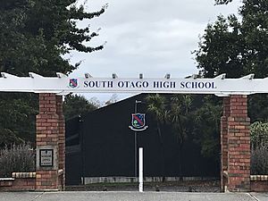
- South Otago High School is a state secondary school. It is for students in Year 9 to 13 and has about 524 students.
Tertiary Education
- Telford is a campus of the Southern Institute of Technology. This is where students can go for education after high school.
Climate in Balclutha
Balclutha has a temperate climate. Here's a look at the average weather:
| Climate data for Balclutha (1991–2020) | |||||||||||||
|---|---|---|---|---|---|---|---|---|---|---|---|---|---|
| Month | Jan | Feb | Mar | Apr | May | Jun | Jul | Aug | Sep | Oct | Nov | Dec | Year |
| Mean daily maximum °C (°F) | 19.2 (66.6) |
19.0 (66.2) |
17.9 (64.2) |
15.3 (59.5) |
12.4 (54.3) |
9.5 (49.1) |
9.2 (48.6) |
11.0 (51.8) |
13.2 (55.8) |
14.9 (58.8) |
16.2 (61.2) |
18.2 (64.8) |
14.7 (58.4) |
| Daily mean °C (°F) | 14.2 (57.6) |
14.0 (57.2) |
12.5 (54.5) |
10.2 (50.4) |
7.8 (46.0) |
5.3 (41.5) |
4.7 (40.5) |
6.2 (43.2) |
8.2 (46.8) |
10.0 (50.0) |
11.4 (52.5) |
13.2 (55.8) |
9.8 (49.7) |
| Mean daily minimum °C (°F) | 9.2 (48.6) |
8.9 (48.0) |
7.1 (44.8) |
5.2 (41.4) |
3.1 (37.6) |
1.2 (34.2) |
0.2 (32.4) |
1.4 (34.5) |
3.2 (37.8) |
5.1 (41.2) |
6.5 (43.7) |
8.3 (46.9) |
5.0 (40.9) |
| Average rainfall mm (inches) | 69.0 (2.72) |
62.5 (2.46) |
40.3 (1.59) |
59.9 (2.36) |
74.9 (2.95) |
53.4 (2.10) |
60.7 (2.39) |
32.2 (1.27) |
45.2 (1.78) |
62.1 (2.44) |
52.9 (2.08) |
45.4 (1.79) |
658.5 (25.93) |
| Mean monthly sunshine hours | 213.9 | 186.3 | 168.3 | 130.3 | 116.1 | 109.7 | 112.0 | 143.1 | 171.3 | 199.2 | 200.8 | 214.4 | 1,965.4 |
| Source: NIWA | |||||||||||||
Famous People from Balclutha
Many talented people have come from Balclutha, including:
- Alister Abernethy, a politician
- Ronald Algie, a politician who went to school in Balclutha
- John Barr, a poet
- Aubrey Begg, a politician
- Tony Brown, an All Black rugby player
- Morgan Endicott-Davies, a judo athlete
- Tony Ensor, an international rugby sevens player
- Matt Faddes, a rugby player and international sevens player
- Phillipa Finch, a netball player
- Aaron Gale, an international cricketer
- Paul Grant, a rugby player and international rugby sevens player
- Hone Kouka, a playwright (someone who writes plays)
- Robbie Johnston, an Olympic long-distance runner
- Ian Murray Mackerras, a zoologist (someone who studies animals)
- Clive Matthewson, a politician
- Jan Mortimer, an international draughts player
- Rachel Pullar, a women's international cricketer
- Barbara Tilden, an international hockey player
- Sarah Tsukigawa, a women's international cricketer
- Rob Webster, a virologist (someone who studies viruses)
- Debbie White, an international netball player
- Charles Willocks, a rugby player and All Black
- Jared Wrennall, a band member for Steriogram
- Edward (Ted) Bullmore, a surrealist artist
- Kazuyuki Kiyohei Tsukigawa, an early Japanese New Zealand sailor
Images for kids
See also
 In Spanish: Balclutha (Nueva Zelanda) para niños
 | Calvin Brent |
 | Walter T. Bailey |
 | Martha Cassell Thompson |
 | Alberta Jeannette Cassell |


