Banks Lake facts for kids
Quick facts for kids Banks Lake |
|
|---|---|
 |
|
| Location | Grant / Douglas counties, Washington, United States |
| Coordinates | 47°37′12″N 119°18′27″W / 47.62000°N 119.30750°W |
| Type | reservoir |
| Basin countries | United States |
| Max. length | 31 mi (50 km) |
| Surface area | 26,886 acres (10,880 ha) (42 mi²) |
| Average depth | 46 ft (14 m) |
| Max. depth | 177 ft (54 m) |
| Water volume | 1,237,000 acre-feet (1.526×10⁹ m3) |
| Shore length1 | 135 mi (217 km) |
| Surface elevation | 1,571 ft (479 m) |
| 1 Shore length is not a well-defined measure. | |
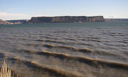
Banks Lake is a large reservoir in central Washington, USA. It stretches for about 27 miles (43 kilometers) and is an important part of a big project that helps bring water to farms in the region.
Contents
What is Banks Lake?
Banks Lake is a long reservoir located in central Washington state, USA. It stretches for about 27 miles (43 kilometers). This lake is a key part of the Columbia Basin Project, which is a huge plan to manage water in the area.
Long ago, during the Ice Age, giant floods called the Missoula Floods carved out a deep valley known as the Grand Coulee. Banks Lake now fills the northern part of this ancient valley.
The lake was created by people, not nature. The Grand Coulee Dam was built on the Columbia River. This dam formed a large lake behind it called Franklin D. Roosevelt Lake.
How Banks Lake Was Formed
The surface of Lake Roosevelt is much higher than the original Columbia River. This makes it easier to pump water about 280 feet (85 meters) up and out of the river's canyon. The water is pumped into the nearby Grand Coulee.
Two smaller dams, Dry Falls Dam and North Dam, were built to hold the water in the Grand Coulee. This is how Banks Lake was created. The lake is named after Frank A. Banks, who was in charge of building the Grand Coulee Dam.
Places Around Banks Lake
Several towns and a state park are located around Banks Lake. At the north end of the lake, you'll find the cities of Grand Coulee and Electric City.
In the north-central part of the lake is Steamboat Rock State Park. This park is a popular spot for outdoor activities. The town of Coulee City is located at the very south end of Banks Lake.
Water for Farming
From the south end of Banks Lake, the stored water is sent out to a large area. This water is used to irrigate farms as part of the Columbia Basin Project. It helps many crops grow in the region.
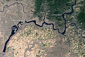
Satellite View of Banks Lake
This satellite photo was taken during the summer. The land in the picture shows different shades of beige, brown, and green. You can see how the natural hills have rough, uneven shapes.
In contrast, the farmed land looks like a network of rectangles. Some fields are deep green, while others are beige or tan. Bright green dots show fields that are watered using special center-pivot irrigation systems.
Most of the farm fields are located south of the dam. North of the reservoir, you can see mostly green, vegetated hills. Flatter areas that are not farmed appear gray-beige. This is probably because they have very few plants growing there, especially in the northwest.
 | Emma Amos |
 | Edward Mitchell Bannister |
 | Larry D. Alexander |
 | Ernie Barnes |


