Barber Peak facts for kids
Quick facts for kids Barber Peak |
|
|---|---|
| Tsé Naajin | |

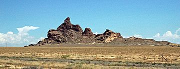
West aspect
|
|
| Highest point | |
| Elevation | 5,778 ft (1,761 m) |
| Prominence | 308 ft (94 m) |
| Isolation | 1.47 mi (2.37 km) |
| Parent peak | Table Mesa (5,850 ft) |
| Geography | |
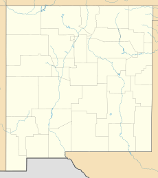
| Location | San Juan County, New Mexico, US |
| Parent range | Chuska Mountains Colorado Plateau |
| Topo map | USGS Table Mesa |
| Geology | |
| Age of rock | Oligocene |
| Mountain type | Volcanic plug |
| Type of rock | Volcanic breccia |
| Climbing | |
| First ascent | 1981 by M. Dalen, D. Nordstrom |
| Easiest route | Southeast gully, class 5.8+ |
Barber Peak is a cool mountain in northwest New Mexico, USA. It stands tall at 5,778 feet (about 1,761 meters) above sea level. This special mountain is a volcanic plug, which means it's the hard rock that filled the vent of an ancient volcano.
You can find Barber Peak on Navajo Nation land in San Juan County. It's a well-known landmark, easy to spot about 15 miles south of the town of Shiprock, New Mexico. It rises about 300 feet (91 meters) from the flat desert around it.
Barber Peak is part of the Navajo Volcanic Field. This area has many interesting rocks that formed about 30 million years ago. These rocks include a type called minette, which is an unusual igneous rock. In the Navajo language, Barber Peak is called Tsé Naajin. This name means "black downward rock."
What is a Volcanic Plug?
A volcanic plug is like the leftover "tooth" of an old volcano. When a volcano erupts, magma (hot, melted rock) pushes up through a central pipe. If the magma cools and hardens inside this pipe, it forms a very tough rock.
Over millions of years, the softer outer parts of the volcano wear away. Wind and rain erode the cone, but the hard rock in the pipe remains. This strong, resistant rock stands alone as a tall, steep-sided peak, like Barber Peak.
How Barber Peak Formed
Barber Peak was created about 30 million years ago. This was during a time called the Oligocene epoch. It formed as part of the Navajo Volcanic Field.
The rocks that make up Barber Peak are mostly volcanic breccia. This is a type of rock made from broken pieces of other rocks cemented together by volcanic ash. It shows how powerful the ancient eruptions were.
Barber Peak is also a type of phreatomagmatic diatreme. This means it formed when hot magma met groundwater. The steam explosion that followed blasted a wide, cone-shaped hole in the ground. The pipe of this explosion then filled with volcanic rock.
Weather Around Barber Peak
The area around Barber Peak has a semi-arid climate. This means it's quite dry, but not a full desert. Winters are cold, and summers can be very hot.
Even though it's dry, any rain that falls on Barber Peak is important. This water flows off the peak and eventually drains into the San Juan River. The San Juan River is a major river in the region.
More to Explore
 | Ernest Everett Just |
 | Mary Jackson |
 | Emmett Chappelle |
 | Marie Maynard Daly |


