
Barrier Peak facts for kids
Quick facts for kids Barrier Peak |
|
|---|---|

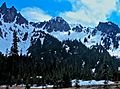
Barrier Peak seen from Sourdough Ridge
|
|
| Highest point | |
| Elevation | 6,521 ft (1,988 m) |
| Prominence | 281 ft (86 m) |
| Geography | |

Barrier Peak
Location in Washington (state)

Barrier Peak
Location in the United States
|
|
| Location | Mount Rainier National Park, Pierce County, Washington, U.S. |
| Parent range | Cascades |
| Topo map | USGS Chinook Pass |
| Climbing | |
| Easiest route | Scrambling class 3 |
Barrier Peak is a mountain peak that stands 6,521 feet (1,988 meters) tall. It is located inside Mount Rainier National Park in Washington state. This peak is part of the Cascade Range, a long chain of mountains.
Barrier Peak is found west of Cayuse Pass. It is also near Buell Peak and Governors Ridge. Governors Ridge is the closest mountain that is taller than Barrier Peak. People usually reach Barrier Peak by hiking the Owyhigh Lakes Trail. The peak got its name because it acts like a natural wall between the Cayuse Pass area and the rest of Mount Rainier National Park.
Weather at Barrier Peak
Barrier Peak is in a special weather area called a marine west coast climate. This means it gets a lot of rain and snow. Most of the weather systems start over the Pacific Ocean. They then travel northeast towards the Cascade Mountains.
When these weather systems hit the tall Cascade Mountains, they are forced to rise. As the air goes up, it cools down and drops its moisture. This causes a lot of rain or snow to fall on the mountains. Because of this, the western side of the Cascades gets a lot of precipitation, especially in winter.
During the winter, the weather is usually cloudy. However, in the summer, high-pressure systems over the Pacific Ocean often bring clear skies. The snow here tends to be wet and heavy. This can sometimes lead to a high risk of avalanches. The water from Barrier Peak flows into rivers like the White River and Cowlitz River.
Images for kids
-
Barrier Peak (centered) seen from Owyhigh Lakes with Governors Needle (left)
-
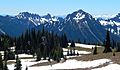
Governors Ridge, Barrier Peak, and Tamanos Mountain seen from the Sunrise area


