Bay of Islands, Newfoundland and Labrador facts for kids
Quick facts for kids Bay of Islands |
|
|---|---|

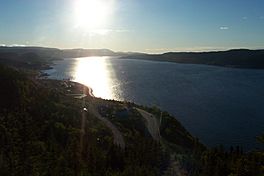
The Humber Arm of the Bay of Islands
|
|
| Location | Newfoundland and Labrador |
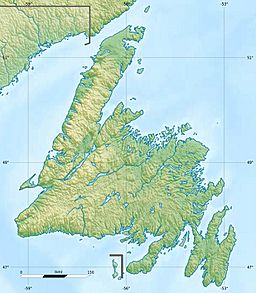
| Coordinates | 49°09′57″N 58°15′51″W / 49.16583°N 58.26417°W |
| Native name | Elmastukwek (Mi'kmaq) |
| River sources | Humber River |
| Ocean/sea sources | Gulf of St. Lawrence, North Atlantic Ocean |
| Basin countries | Canada |
| Islands | Eagle Island, French Island, Governors Island, Green Island, Guernsey Island, Hen Island, Outer Shag Rock, Puffin Island, Seal Island, Shag Rocks, Sleep Island, The Hat, Tweed Island, Pearl Island, & Woods Island (largest), |
The Bay of Islands is a large inlet found on the west coast of Newfoundland, an island in Canada. It's a beautiful natural harbor surrounded by mountains. The biggest island inside the bay is Woods Island, which used to have people living on it. The bay is also part of the larger Gulf of St. Lawrence.
Contents
Discovering the Bay of Islands
The Bay of Islands is a very important natural area. It's known for its stunning scenery and rich history. Many smaller inlets, like Humber Arm and Goose Arm, branch off from the main bay.
Where is the Bay of Islands Located?
This large bay is nestled between the Long Range Mountains and the Lewis Hills. These mountains create a dramatic landscape around the water. The Bay of Islands is a "sub-basin," meaning it's a smaller part of the much larger Gulf of St. Lawrence.
Rivers and Cities of the Bay
The Humber River flows into the Bay of Islands. This river is one of the biggest on Newfoundland island. It drains water from Deer Lake and forms an important estuary where fresh and salt water mix.
Corner Brook: A Major City
Near where the Humber River meets the bay is the city of Corner Brook. This city is a central hub for the area. For many years, logs were floated down the Humber River to Corner Brook. A large paper mill there turned the logs into paper products. Today, logs are moved by truck, but the bay is still busy with ships coming and going from Corner Brook's port.
Communities Along the Bay
Many towns and communities are located along the shores of the Bay of Islands. Most of these places rely on the fishing industry.
Southern Shore Communities
On the southern side of Humber Arm, you'll find communities like Mt Moriah, Humber Arm South, Lark Harbour, and York Harbour.
Northern Shore Communities
On the northern side of Humber Arm, there are towns such as Hughes Brook, Irishtown-Summerside, Meadows, Gillams, and McIvers.
Middle Arm Communities
North of Humber Arm, along Middle Arm, is Cox's Cove. Some of these communities, including Cox's Cove, Humber Arm South, and Curling, still have fish processing plants. Curling used to be its own town but is now part of Corner Brook.
Mountains Surrounding the Bay
The Bay of Islands is surrounded by impressive mountains. To the north and south, you'll see the North Arm Hills and Blow Me Down mountains. These are part of a larger geological area that also includes the Lewis Hills and the Tablelands. These mountains add to the beautiful and rugged scenery of the bay.
 | Sharif Bey |
 | Hale Woodruff |
 | Richmond Barthé |
 | Purvis Young |


