Bayard, Nebraska facts for kids
Quick facts for kids
Bayard, Nebraska
|
|
|---|---|

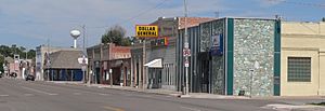
Main Street
|
|

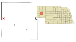
Location in Morrill County and the state of Nebraska
|
|
| Country | United States |
| State | Nebraska |
| County | Morrill |
| Area | |
| • Total | 0.69 sq mi (1.80 km2) |
| • Land | 0.69 sq mi (1.80 km2) |
| • Water | 0.00 sq mi (0.00 km2) |
| Elevation | 3,763 ft (1,147 m) |
| Population
(2020)
|
|
| • Total | 1,140 |
| • Density | 1,640.29/sq mi (633.09/km2) |
| Time zone | UTC-7 (Mountain (MST)) |
| • Summer (DST) | UTC-6 (MDT) |
| ZIP code |
69334
|
| Area code(s) | 308 |
| FIPS code | 31-03285 |
| GNIS feature ID | 2394089 |
Bayard is a city located in Morrill County, Nebraska, United States. In 2020, about 1,140 people lived there.
Contents
History of Bayard
The original town of Bayard was started in the 1880s. It was named after the city of Bayard, Iowa. The first post office in Bayard opened in 1888.
In 1900, the entire town of Bayard was moved to its current spot. This move happened so the town could be closer to the new Union Pacific Railroad line. Being near the railroad was important for trade and travel.
A CCC camp, called BR-61, was also located in Bayard. This camp was part of the North Platte Project, which helped with conservation efforts during the Great Depression.
Where is Bayard?
Bayard is in the western part of Morrill County. It is less than 2 miles (3.2 km) north of the North Platte River.
U.S. Route 26 goes through the city and is known as Main Street. This highway connects Bayard to other towns. It goes northwest about 23 miles (37 km) to Scottsbluff. It also goes southeast about 15 miles (24 km) to Bridgeport, which is the main town in Morrill County.
The U.S. Census Bureau says that Bayard covers a total area of about 0.70 square miles (1.8 km²). All of this area is land.
Population and People
The population of Bayard has changed over the years. Here is a quick look at how many people have lived there:
| Historical population | |||
|---|---|---|---|
| Census | Pop. | %± | |
| 1910 | 261 | — | |
| 1920 | 2,127 | 714.9% | |
| 1930 | 1,559 | −26.7% | |
| 1940 | 2,121 | 36.0% | |
| 1950 | 1,869 | −11.9% | |
| 1960 | 1,519 | −18.7% | |
| 1970 | 1,338 | −11.9% | |
| 1980 | 1,435 | 7.2% | |
| 1990 | 1,196 | −16.7% | |
| 2000 | 1,247 | 4.3% | |
| 2010 | 1,209 | −3.0% | |
| 2020 | 1,140 | −5.7% | |
| U.S. Decennial Census | |||
People in 2010
In 2010, there were 1,209 people living in Bayard. There were 484 households, which are groups of people living together. Many of these were families.
The average age of people in the city was about 40 years old. About 26% of the residents were under 18 years old.
Famous People from Bayard
- John Harms was a politician who served in the Nebraska state government.
See also
 In Spanish: Bayard (Nebraska) para niños
 | Shirley Ann Jackson |
 | Garett Morgan |
 | J. Ernest Wilkins Jr. |
 | Elijah McCoy |


