Bedford, Iowa facts for kids
Quick facts for kids
Bedford, Iowa
|
|
|---|---|
 |
|

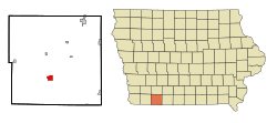
Location of Bedford, Iowa
|
|
| Country | |
| State | |
| County | Taylor |
| Area | |
| • Total | 1.61 sq mi (4.18 km2) |
| • Land | 1.60 sq mi (4.16 km2) |
| • Water | 0.01 sq mi (0.02 km2) |
| Elevation | 1,171 ft (357 m) |
| Population
(2020)
|
|
| • Total | 1,508 |
| • Density | 939.56/sq mi (362.70/km2) |
| Time zone | UTC-6 (Central (CST)) |
| • Summer (DST) | UTC-5 (CDT) |
| ZIP code |
50833
|
| Area code(s) | 712 |
| FIPS code | 19-05365 |
| GNIS feature ID | 2394105 |
Bedford is a city located in Taylor County, Iowa, in the United States. In 2020, about 1,508 people lived there. Bedford is also the main town, or county seat, of Taylor County. A fun place nearby is Lake of Three Fires State Park, just a few miles northeast of the city.
Contents
History of Bedford
How Bedford Got Its Name
Many people believe Bedford was named after Thomas J. Bedford. He was a very important Pony Express rider. On April 23, 1861, he delivered the mail on the last part of its journey in California.
Thomas J. Bedford might have also run a store and trading post in the area around 1848. He later moved to California during the California Gold Rush.
Early Days of the Community
Before it was called Bedford, the community had a post office named "Grove." This post office opened on June 30, 1855. On June 24, 1856, the name was officially changed to Bedford.
There are a few ideas about where the name "Bedford" truly came from:
- It could be named after Bedford in England. Some early settlers might have come from there.
- Another idea is Bedford, Indiana, which was supposedly the home of the surveyor who mapped out the town.
- Some also think it was named after Bedford, Pennsylvania, where a "government engineer" was said to be from.
Becoming the County Seat
Bedford officially became the main town of Taylor County in 1853. This was decided by a special law. The town was planned out, and land lots were sold on July 4, 1853. At that time, the community was sometimes called "Bedforde."
A local story says that a barrel of whiskey was placed on the grounds during the first land sales. Lots were sold for $10 to $20, but no one actually paid for them at that moment!
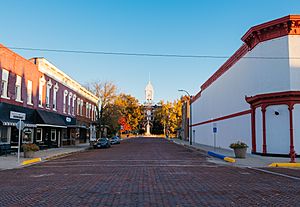
The current Taylor County Courthouse was built in 1893. It is an important building in the city.
Transportation in Bedford
Bedford used to have a train line. This line was part of the Burlington Northern Railroad. It connected Creston, Iowa, to St. Joseph, Missouri. However, this train line was removed in the late 1970s and early 1980s.
Today, Bedford is served by two main highways. Iowa Highway 148 runs north and south. Iowa Highway 2 goes east and west, connecting many towns in southern Iowa. There are also many good paved roads for farms in the area.
Geography
Bedford is located next to the East Fork of the One Hundred and Two River.
The city covers a total area of about 1.61 square miles (4.18 square kilometers). Most of this area is land, about 1.60 square miles (4.16 square kilometers). A small part, about 0.01 square miles (0.02 square kilometers), is water. This information comes from the United States Census Bureau.
Climate
Bedford has a type of climate called a hot-summer humid continental climate. This means it has warm, humid summers and cold winters. On climate maps, this is often shown as "Dfa."
| Climate data for Bedford, Iowa, 1991–2020 normals, extremes 1898–2018 | |||||||||||||
|---|---|---|---|---|---|---|---|---|---|---|---|---|---|
| Month | Jan | Feb | Mar | Apr | May | Jun | Jul | Aug | Sep | Oct | Nov | Dec | Year |
| Record high °F (°C) | 68 (20) |
76 (24) |
90 (32) |
94 (34) |
97 (36) |
102 (39) |
110 (43) |
108 (42) |
107 (42) |
94 (34) |
81 (27) |
70 (21) |
110 (43) |
| Mean maximum °F (°C) | 55.0 (12.8) |
60.2 (15.7) |
74.2 (23.4) |
83.3 (28.5) |
86.5 (30.3) |
91.7 (33.2) |
96.1 (35.6) |
95.0 (35.0) |
90.0 (32.2) |
82.3 (27.9) |
69.2 (20.7) |
56.1 (13.4) |
97.5 (36.4) |
| Mean daily maximum °F (°C) | 31.9 (−0.1) |
37.1 (2.8) |
49.9 (9.9) |
62.0 (16.7) |
72.0 (22.2) |
81.6 (27.6) |
85.6 (29.8) |
84.0 (28.9) |
77.1 (25.1) |
64.7 (18.2) |
49.4 (9.7) |
36.8 (2.7) |
61.0 (16.1) |
| Daily mean °F (°C) | 22.2 (−5.4) |
26.7 (−2.9) |
38.7 (3.7) |
50.1 (10.1) |
61.3 (16.3) |
71.3 (21.8) |
75.5 (24.2) |
73.6 (23.1) |
65.4 (18.6) |
52.8 (11.6) |
38.9 (3.8) |
27.6 (−2.4) |
50.3 (10.2) |
| Mean daily minimum °F (°C) | 12.4 (−10.9) |
16.3 (−8.7) |
27.6 (−2.4) |
38.2 (3.4) |
50.5 (10.3) |
61.1 (16.2) |
65.4 (18.6) |
63.1 (17.3) |
53.7 (12.1) |
40.9 (4.9) |
28.5 (−1.9) |
18.4 (−7.6) |
39.7 (4.3) |
| Mean minimum °F (°C) | −9.0 (−22.8) |
−4.5 (−20.3) |
7.7 (−13.5) |
22.9 (−5.1) |
36.6 (2.6) |
47.6 (8.7) |
54.5 (12.5) |
51.6 (10.9) |
36.8 (2.7) |
24.5 (−4.2) |
11.8 (−11.2) |
−4.4 (−20.2) |
−15.2 (−26.2) |
| Record low °F (°C) | −32 (−36) |
−34 (−37) |
−24 (−31) |
1 (−17) |
19 (−7) |
37 (3) |
40 (4) |
37 (3) |
22 (−6) |
10 (−12) |
−11 (−24) |
−30 (−34) |
−34 (−37) |
| Average precipitation inches (mm) | 1.08 (27) |
1.49 (38) |
2.42 (61) |
3.60 (91) |
5.27 (134) |
5.54 (141) |
4.64 (118) |
4.32 (110) |
3.38 (86) |
2.97 (75) |
2.13 (54) |
1.59 (40) |
38.43 (975) |
| Average snowfall inches (cm) | 7.6 (19) |
7.2 (18) |
3.3 (8.4) |
1.3 (3.3) |
0.0 (0.0) |
0.0 (0.0) |
0.0 (0.0) |
0.0 (0.0) |
0.0 (0.0) |
0.1 (0.25) |
0.7 (1.8) |
7.9 (20) |
28.1 (70.75) |
| Average precipitation days (≥ 0.01 in) | 5.5 | 6.5 | 8.0 | 10.5 | 11.6 | 9.8 | 9.2 | 8.9 | 7.2 | 7.6 | 6.0 | 6.6 | 97.4 |
| Average snowy days (≥ 0.1 in) | 3.0 | 3.3 | 1.4 | 0.5 | 0.0 | 0.0 | 0.0 | 0.0 | 0.0 | 0.0 | 0.5 | 3.7 | 12.4 |
| Source 1: NOAA | |||||||||||||
| Source 2: National Weather Service (mean maxima and minima 1981–2010) | |||||||||||||
People of Bedford
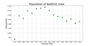
| Historical populations | ||
|---|---|---|
| Year | Pop. | ±% |
| 1870 | 720 | — |
| 1880 | 1,763 | +144.9% |
| 1890 | 1,643 | −6.8% |
| 1900 | 1,977 | +20.3% |
| 1910 | 1,883 | −4.8% |
| 1920 | 2,073 | +10.1% |
| 1930 | 2,100 | +1.3% |
| 1940 | 2,151 | +2.4% |
| 1950 | 2,000 | −7.0% |
| 1960 | 1,807 | −9.7% |
| 1970 | 1,733 | −4.1% |
| 1980 | 1,692 | −2.4% |
| 1990 | 1,528 | −9.7% |
| 2000 | 1,620 | +6.0% |
| 2010 | 1,440 | −11.1% |
| 2020 | 1,508 | +4.7% |
| Source: and Iowa Data Center Source: |
||
2020 Census Information
In 2020, a survey called the census counted 1,508 people living in Bedford. There were 620 households, which are groups of people living together. About 376 of these were families.
The city had about 939 people per square mile (362.7 people per square kilometer). This is called population density. Most people in Bedford were White (94.2%). A small number were from other racial groups. About 1.5% of the population was Hispanic or Latino.
About 28.9% of households had children under 18 living with them. Many households (47.4%) were married couples. Some households (39.4%) were not families. About 33.4% of all households had only one person living there.
The average age in Bedford was 39.0 years old. About 28.2% of residents were under 20. About 23.3% were 65 years old or older. The city had slightly more females (52.1%) than males (47.9%).
2010 Census Information
In 2010, the census counted 1,440 people in Bedford. There were 614 households and 382 families. The population density was about 900 people per square mile.
Most people (97.4%) were White. A small number were from other racial groups. About 1.3% of the population was Hispanic or Latino.
About 28.2% of households had children under 18. Many households (50.3%) were married couples. About 37.8% of households were not families. About 33.1% of households had only one person living there.
The average age in 2010 was 43.9 years. About 24.1% of residents were under 18. About 23.2% were 65 years old or older. The city had slightly more females (52.8%) than males (47.2%).
Education
Students in Bedford attend schools within the Bedford Community School District.
See also
 In Spanish: Bedford (Iowa) para niños


