
Beekmantown, New York facts for kids
Quick facts for kids
Beekmantown, New York
|
|
|---|---|

Beekmantown
|
|

Location in Clinton County and the state of New York.
|
|
| Country | United States |
| State | New York |
| County | Clinton |
| Government | |
| • Type | Town Council |
| Area | |
| • Total | 69.63 sq mi (180.33 km2) |
| • Land | 60.42 sq mi (156.50 km2) |
| • Water | 9.20 sq mi (23.83 km2) |
| Elevation | 285 ft (87 m) |
| Population
(2010)
|
|
| • Total | 5,545 |
| • Estimate
(2016)
|
5,503 |
| • Density | 91.07/sq mi (35.16/km2) |
| Time zone | UTC-5 (Eastern (EST)) |
| • Summer (DST) | UTC-4 (EDT) |
| ZIP code |
12901
|
| Area code(s) | 518 |
| FIPS code | 36-019-05485 |
| GNIS feature ID | 0978719 |
Beekmantown is a small town in Clinton County, New York, in the United States. In 2010, about 5,545 people lived there. The town is named after William Beekman, who was an early landowner. It is located on the eastern side of the county, just north of the city of Plattsburgh.
Contents
A Look Back at Beekmantown's History
People first started settling in the area around 1783. The town of Beekmantown was officially created in 1820. It was formed from a part of the nearby town of Plattsburgh. Later, in 1854, some of Beekmantown's land was used to create the new town of Dannemora.
During the War of 1812, which was a conflict between the United States and Great Britain, some small battles happened in Beekmantown in 1814.
Where is Beekmantown? (Geography)
Beekmantown covers a total area of about 180.3 square kilometers (about 69.6 square miles). Most of this area, about 156.5 square kilometers (60.4 square miles), is land. The rest, about 23.8 square kilometers (9.2 square miles), is water.
The eastern edge of Beekmantown goes through the middle of the western part of Lake Champlain. This lake forms the border between New York and the state of Vermont.
Getting Around: Roads and Highways
Several important roads run through Beekmantown. The Adirondack Northway, also known as Interstate 87, and U.S. Route 9 are major highways that go north and south through the eastern part of the town. You can get onto I-87 from Exit 40.
Other north-south roads include New York State Route 22 and New York State Route 190. A road called Clinton County Route 58, also known as Spellman Road, goes east and west.
Who Lives in Beekmantown? (Population)
| Historical population | |||
|---|---|---|---|
| Census | Pop. | %± | |
| 1820 | 1,343 | — | |
| 1830 | 2,391 | 78.0% | |
| 1840 | 2,769 | 15.8% | |
| 1850 | 3,384 | 22.2% | |
| 1860 | 2,977 | −12.0% | |
| 1870 | 2,552 | −14.3% | |
| 1880 | 2,644 | 3.6% | |
| 1890 | 2,159 | −18.3% | |
| 1900 | 2,067 | −4.3% | |
| 1910 | 1,866 | −9.7% | |
| 1920 | 1,590 | −14.8% | |
| 1930 | 1,533 | −3.6% | |
| 1940 | 1,704 | 11.2% | |
| 1950 | 1,690 | −0.8% | |
| 1960 | 2,538 | 50.2% | |
| 1970 | 3,189 | 25.7% | |
| 1980 | 4,275 | 34.1% | |
| 1990 | 5,108 | 19.5% | |
| 2000 | 5,334 | 4.4% | |
| 2010 | 5,545 | 4.0% | |
| 2016 (est.) | 5,503 | −0.8% | |
| U.S. Decennial Census | |||
According to the census from 2000, there were 5,326 people living in Beekmantown. These people lived in 2,004 households, and 1,476 of those were families. The population has grown quite a bit over the years, from 1,343 people in 1820 to 5,545 in 2010.
The average household in Beekmantown had about 2.65 people. About 26.3% of the people living in the town were under 18 years old. The average age of people in Beekmantown was 37 years old.
Places to See in Beekmantown
Beekmantown has several interesting communities and locations:
- Beartown – This is a small area located southwest of West Beekmantown.
- Beekmantown (or "Beekmantown Corners") – This is the main village, or hamlet, of Beekmantown. You can find it near the center of the town on NY-22.
- East Beekmantown – Another hamlet located southeast of the main Beekmantown hamlet, also on NY-22.
- Gilroy Corners – An area found south of West Beekmantown.
- Ingraham – A hamlet located on the northern border of the town, along US-9.
- Lawliss Corners – A hamlet situated on the southern border of the town.
- Monty's Bay Wildlife Management Area – This is a special area set aside to protect wildlife, located near Point au Roche.
- Point au Roche – This is a piece of land that sticks out into Lake Champlain. It's also the name of a small settlement in the northeastern part of Beekmantown.
- Point Au Roche State Park – A beautiful state park right on the shore of Lake Champlain, perfect for outdoor activities.
- St. Armand Beach – A spot located close to Treadwell Bay.
- Treadwell Bay – A bay that is part of Lake Champlain, found south of the state park.
- West Beekmantown – A hamlet located in the western part of the town, on NY-190.
- New York State Welcome Center/Beekmantown Rest Area – A place along Interstate 87 where travelers can stop, rest, and get information about New York State.
Learning in Beekmantown (Schools)
Students in Beekmantown attend schools that are part of the Beekmantown Central School District. This district serves students from kindergarten all the way through 12th grade.
Younger students go to Beekmantown Elementary School. When students reach 6th grade, they move on to Beekmantown Middle School, which serves grades 6-8. This middle school also welcomes students from the Cumberland Head area of Plattsburgh.
After middle school, students attend Beekmantown High School. The high school and middle school share a building, but they have their own gyms, locker rooms, hallways, and classrooms. The school campus is located on Spellman Road in West Chazy, New York.
Images for kids
-
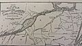
A map from the War of 1812 showing Beekmantown in the lower right corner.

See also
 In Spanish: Beekmantown (Nueva York) para niños
