Bell County, Kentucky facts for kids
Quick facts for kids
Bell County
|
||
|---|---|---|

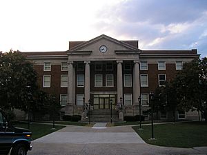
Bell County Courthouse in Pineville
|
||
|
||

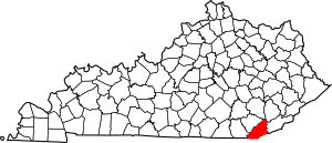
Location within the U.S. state of Kentucky
|
||
 Kentucky's location within the U.S. |
||
| Country | ||
| State | ||
| Founded | February 5, 1867 | |
| Named for | Joshua Fry Bell | |
| Seat | Pineville | |
| Largest city | Middlesboro | |
| Area | ||
| • Total | 361 sq mi (930 km2) | |
| • Land | 359 sq mi (930 km2) | |
| • Water | 2.1 sq mi (5 km2) 0.6%% | |
| Population
(2020)
|
||
| • Total | 24,097 | |
| • Estimate
(2023)
|
23,317 |
|
| • Density | 66.75/sq mi (25.77/km2) | |
| Time zone | UTC−5 (Eastern) | |
| • Summer (DST) | UTC−4 (EDT) | |
| Congressional district | 5th | |
Bell County is a county located in the southeastern part of the U.S. state of Kentucky. In 2020, about 24,097 people lived here. The main town and county seat is Pineville. The biggest city in Bell County is Middlesboro. The county was created in 1867 from parts of Knox and Harlan counties. It was named after Joshua Fry Bell, who was a US Representative. The county was first called "Josh Bell," but its name was shortened to "Bell" in 1873.
Contents
History of Bell County
Bell County has an interesting history. For a long time, there were strict rules about selling alcohol. In 2015, some rules changed, allowing alcohol sales in restaurants in Middlesboro, Kentucky. Later, in 2020, voters in Middlesboro approved more widespread alcohol sales.
The Middlesborough, KY Micropolitan Statistical Area includes all of Bell County. This means the county is part of a larger area that is connected by jobs and daily life.
An important path called the Wilderness Road was built through what is now Bell County in 1775. This road was very important for early settlers moving west.
Bell County was officially formed in 1867. It was named after Joshua Fry Bell, who was a lawyer and a member of Congress. The county courthouse, where important records are kept, has been damaged three times. It was destroyed by fire in 1914 and 1918. In 1977, a flood caused a lot of damage to the building and destroyed many documents.
The community of "South America," now known as Frakes since the 1930s, has a long history. It might have been settled during the Spanish era, even before English settlers arrived. This area has ties to Native American traditions of gathering and selling herbs.
Bell County is special because it has both a State Park, Pine Mountain State Resort Park, and a National Monument, Cumberland Gap National Historical Park.
Geography of Bell County
Bell County covers about 361 square miles. Most of this area, about 359 square miles, is land. The rest, about 2.1 square miles, is water.
Neighboring Counties
- Clay County (north)
- Leslie County (northeast)
- Harlan County (east)
- Lee County, Virginia (southeast)
- Claiborne County, Tennessee (south)
- Whitley County (southwest)
- Knox County (northwest)
Protected Natural Areas
- Cumberland Gap National Historical Park (part of it is in Bell County)
People of Bell County
| Historical population | |||
|---|---|---|---|
| Census | Pop. | %± | |
| 1870 | 3,731 | — | |
| 1880 | 6,055 | 62.3% | |
| 1890 | 10,312 | 70.3% | |
| 1900 | 15,701 | 52.3% | |
| 1910 | 28,447 | 81.2% | |
| 1920 | 33,988 | 19.5% | |
| 1930 | 38,747 | 14.0% | |
| 1940 | 43,812 | 13.1% | |
| 1950 | 47,602 | 8.7% | |
| 1960 | 35,336 | −25.8% | |
| 1970 | 31,121 | −11.9% | |
| 1980 | 34,330 | 10.3% | |
| 1990 | 31,506 | −8.2% | |
| 2000 | 30,060 | −4.6% | |
| 2010 | 28,691 | −4.6% | |
| 2020 | 24,097 | −16.0% | |
| 2023 (est.) | 23,317 | −18.7% | |
| U.S. Decennial Census 1790-1960 1900-1990 1990-2000 2010-2020 |
|||
In 2000, there were about 30,060 people living in Bell County. Most people were White (96.02%), with smaller groups of Black or African American (2.40%), Native American (0.25%), and Asian (0.35%) people. About 0.65% of the population was Hispanic or Latino.
The average age of people in Bell County in 2000 was 37 years old. About 24.40% of the population was under 18 years old.
Education in Bell County
There are three public school districts in Bell County:
Bell County School District
This is the largest school district in Bell County. It covers the biggest area and has the most students. The district has six schools for grades K-8, one alternative school, and one high school. There is also a new technology center that helps students learn important skills for jobs.
Middlesboro Independent Schools
This is the second largest school district. Its boundaries match the city limits of Middlesboro. This district has one elementary school, one middle school, and one high school.
Pineville Independent Schools
This is the smallest school district in the county. Its boundaries are mostly within the city of Pineville. This district operates Pineville School, which includes elementary, middle, and high school grades all in one place.
Communities in Bell County
Cities
- Middlesboro
- Pineville (the county seat)
Census-designated place
Other Unincorporated Communities
- Beverly
- Black Snake
- Blackmont
- Colmar
- Cubage
- Field
- Fonde
- Fourmile
- Frakes
- Harbell
- Hutch
- Ingram
- Jaybel
- Jenson
- Keenox
- Kettle Island
- Meldrum
- Miracle
- Mocking Bird Branch
- Noetown
- Oaks
- Olcott
- Ponza
- Premier
- Pruden‡
- Red Oak
- Rella
- Stoney Fork
- Stony Fork Junction
- Sugar Run
- Tejay
- Timsley
- Tuggleville
- Varilla
- Wallsend
- Wasioto
- Flatshoales
Notable People from Bell County
- George Samuel Hurst
- Lee Majors
- Matt Jones (radio host)
- Dale Ann Bradley
See also
 In Spanish: Bell County (Kentucky) para niños
 | Shirley Ann Jackson |
 | Garett Morgan |
 | J. Ernest Wilkins Jr. |
 | Elijah McCoy |


