Belle Fourche, South Dakota facts for kids
Quick facts for kids
Belle Fourche
|
|
|---|---|

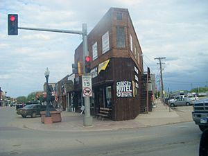
Belle Fourche's Business District in 2009
|
|

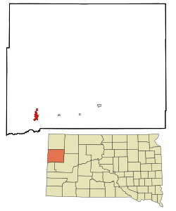
Location in Butte County (top) and South Dakota (bottom)
|
|
| Country | United States |
| State | South Dakota |
| County | Butte |
| Founded | 1884 |
| Incorporated | April 20, 1903 |
| Area | |
| • Total | 8.93 sq mi (23.12 km2) |
| • Land | 8.85 sq mi (22.93 km2) |
| • Water | 0.07 sq mi (0.19 km2) |
| Elevation | 3,117 ft (950 m) |
| Population
(2020)
|
|
| • Total | 5,617 |
| • Estimate
(2022)
|
5,848 |
| • Density | 634.40/sq mi (244.94/km2) |
| Time zone | UTC–7 (Mountain (MST)) |
| • Summer (DST) | UTC–6 (MDT) |
| ZIP code |
57717
|
| Area code(s) | 605 |
| Sales tax | 6.2% |
| GNIS feature ID | 1267280 |
Belle Fourche is a city in South Dakota, United States. It is the county seat of Butte County, South Dakota. This means it is the main town where the county government is located. In 2020, about 5,617 people lived there.
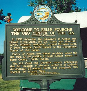
Belle Fourche is special because it is very close to the geographic center of the United States. This spot moved to South Dakota when Alaska and Hawaii became states.
Contents
History of Belle Fourche
The name "Belle Fourche" comes from the French language. It means "beautiful fork." French explorers gave it this name because of where the Belle Fourche and Redwater Rivers meet. Hay Creek also joins them there.
Long ago, beaver trappers worked on these rivers. Belle Fourche became a famous meeting spot for fur traders. After the Black Hills Gold Rush in 1876, farmers and ranchers moved to the area. They grew food for the miners and their animals.
In 1884, a French nobleman named the Marquis de Mores started a stagecoach line. It ran between Medora, North Dakota and Deadwood, South Dakota. Belle Fourche had a stop for the stagecoach, which included a barn and a saloon.
Seth Bullock helped found the city of Belle Fourche. He knew that cattle owners and the railroad would need a place to load cattle. Bullock bought land along the Belle Fourche River. When the railroad came, he offered them free land. He also offered to build the train station. This was if they put it on his land.
In 1890, the first train full of cattle left Belle Fourche. By 1895, Belle Fourche was shipping 2,500 train carloads of cattle each month. This made it the world's largest place for shipping livestock. This was the start of Belle Fourche becoming a major farming and ranching center.
Belle Fourche also won a competition to become the county seat in 1894. Today, Belle Fourche is still an important center for ranches and farms. The wool, cattle, and bentonite (a type of clay) industries are very important here. The city is also known as the gateway to the northern Black Hills.
Geography of Belle Fourche
Belle Fourche covers about 8.60 square miles (22.27 square kilometers). Most of this area is land, with a small part being water.
The Geographic Center of the U.S.
In 1959, a special survey group officially named a spot near Belle Fourche as the geographic center of the United States. This point is about 20 miles (32 km) north of the city. It became the center of the nation when Alaska and Hawaii joined the United States. The center of the lower 48 states is in Lebanon, Kansas.
Climate and Weather
Belle Fourche has a climate with warm summers and cold winters. Spring is often wet with thunderstorms. Summers can be very hot and dry. Fall brings quick cooling.
In winter, temperatures can drop very low when cold air comes from the north. However, warm winds called "chinook winds" can also make winter days much warmer. For example, the temperature once jumped 93 degrees Fahrenheit (51 degrees Celsius) in less than two days!
Snowfall is common in winter and spring. The snowiest month ever recorded was October 2013. It had 34.2 inches (87 cm) of snow.
People of Belle Fourche
| Historical population | |||
|---|---|---|---|
| Census | Pop. | %± | |
| 1900 | 451 | — | |
| 1910 | 1,352 | 199.8% | |
| 1920 | 1,616 | 19.5% | |
| 1930 | 2,032 | 25.7% | |
| 1940 | 2,496 | 22.8% | |
| 1950 | 3,540 | 41.8% | |
| 1960 | 4,087 | 15.5% | |
| 1970 | 4,236 | 3.6% | |
| 1980 | 4,692 | 10.8% | |
| 1990 | 4,335 | −7.6% | |
| 2000 | 4,565 | 5.3% | |
| 2010 | 5,594 | 22.5% | |
| 2020 | 5,617 | 0.4% | |
| 2022 (est.) | 5,848 | 4.5% | |
| U.S. Decennial Census 2020 Census |
|||
Population in 2010
In 2010, there were 5,594 people living in Belle Fourche. There were 2,322 households, which are groups of people living in one home. About 1,461 of these were families. The city had about 656 people per square mile (253 people per square kilometer).
Most people in Belle Fourche were White (93.6%). Some were Native American (2.1%) or from other backgrounds. About 4.1% of the population was Hispanic or Latino.
About 32.8% of households had children under 18. Many households (46.0%) were married couples. About 13% of households had someone aged 65 or older living alone. The average age in the city was 36.1 years.
Radio and TV Stations
|
AM radio
|
FM radio
|
Television |
Notable People
Many interesting people have connections to Belle Fourche:
- Dianne Dorland: An engineer who was the first female president of the American Institute of Chemical Engineers.
- Lloyd Eaton: A football player, executive, and coach.
- Jason Kubel: A retired Major League Baseball player who was born in Belle Fourche.
- Lem Overpeck: The 29th Lieutenant Governor of South Dakota, also born in Belle Fourche.
- Bill Pearson: A comics artist born in Belle Fourche.
- Emily E. Sloan: A rancher, lawyer, and author who used to live here.
- John Strohmayer: A former baseball pitcher born in Belle Fourche.
- Francis Townsend: A doctor and political activist who used to live here.
See also
 In Spanish: Belle Fourche (Dakota del Sur) para niños


