
Benleagh facts for kids
Quick facts for kids Benleagh |
|
|---|---|
| Binn Liath | |

Southerly cliffs of Benleagh as viewed from the Fraughan Rock Glen
|
|
| Highest point | |
| Elevation | 689 m (2,260 ft) |
| Prominence | 24 m (79 ft) |
| Listing | Vandeleur-Lynam |
| Naming | |
| English translation | grey peak |
| Language of name | Irish |
| Geography | |
|
Lua error in Module:Location_map at line 420: attempt to index field 'wikibase' (a nil value).
|
|
| Location | Wicklow, Ireland |
| Parent range | Wicklow Mountains |
| OSI/OSNI grid | T038941 |
| Topo map | OSi Discovery 56 |
| Geology | |
| Mountain type | Aphyric granodiorite Bedrock |
Benleagh (Irish: Binn Liath, meaning Grey Peak) is a mountain in the beautiful Wicklow Mountains in Ireland. It stands tall at 689 meters (about 2,260 feet) above sea level. While it's not one of the highest mountains, it's still an important peak in the area.
Benleagh is located in the southern part of the Wicklow Mountains. It's part of a much larger group of mountains called the Lugnaquilla massif. Lugnaquilla is the highest mountain in Wicklow, reaching 925 meters (about 3,035 feet).
Mountain Features
One of the most interesting features of Benleagh is its southern side. This side forms the steep walls and cliffs of a special valley called Fraughan Rock Glen. This glen is a "hanging valley," which means it sits high up before dropping into the larger, U-shaped Glenmalure valley below.
Benleagh, along with Lugnaquilla and Cloghernagh (which is 800 meters tall), forms a "horseshoe" shape around the Fraughan Rock Glen. Lugnaquilla is at the top of this horseshoe.
Benleagh also sits on a long ridge or "spine" of land. This spine connects Lugnaquilla in the south to other mountains like Camenabologue and Table Mountain to the north. These mountains together form a circle around an area known as the Glen of Imaal.
Gallery
-
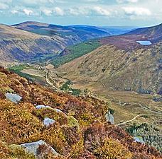
View south-east from summit of Benleagh
-
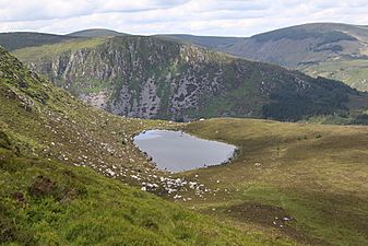
Cliffs of Benleagh from Arts Lough, below summit of Cloghernagh
-
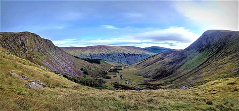
View east across the Fraughan Rock Glen with Benleagh (left) and Cloghernagh (right)


