
Bergün/Bravuogn facts for kids
Quick facts for kids
Bergün/Bravuogn
|
||
|---|---|---|
 |
||
|
||

Bergün/Bravuogn
Location in Switzerland

Bergün/Bravuogn
Location in Canton of Graubünden
|
||
| Country | Switzerland | |
| Canton | Graubünden | |
| District | Albula | |
| Area | ||
| • Total | 145.65 km2 (56.24 sq mi) | |
| Elevation | 1,367 m (4,485 ft) | |
| Population
(December 2020)
|
||
| • Total | 480 | |
| • Density | 3.30/km2 (8.54/sq mi) | |
| Postal code |
7482
|
|
| Localities | Bergün, Latsch, Stuls, Preda | |
| Surrounded by | Bever, Davos, Filisur, La Punt Chamues-ch, Samedan, S-chanf, Tinizong-Rona, Wiesen, Zuoz | |
| Twin towns | Hallau (Switzerland) | |

Bergün/Bravuogn is a charming village in the Albula Region of Graubünden, a canton in Switzerland. Its name is special because it uses both German (Bergün) and Romansh (Bravuogn), which became official in 1943. On January 1, 2018, Bergün/Bravuogn joined with the nearby village of Filisur to form a new municipality called Bergün Filisur.
Contents
History of Bergün/Bravuogn
The village of Bergün/Bravuogn is quite old. It was first written about in the year 1209. Back then, it was known as de Bregonio.
Geography of Bergün/Bravuogn

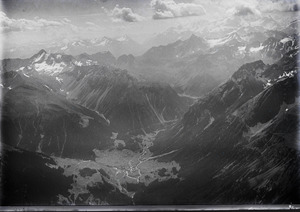
Bergün/Bravuogn covers a large area, about 145.6 square kilometers (56 square miles). A small part of the land is used for farming, and another part is covered by forests. Most of the area is made up of mountains, rivers, and glaciers.
The village is located along the Albula river and the road that goes over the Albula Pass. A small lake called Lai da Ravais-ch is right in the village.
Bergün/Bravuogn is made up of the main village and smaller settlements. These include Latsch, which is on a terrace above the river, and Stugl/Stuls. Latsch joined the municipality in 1912, and Stugl/Stuls joined in 1920. Further up towards the Albula Pass, you'll find Preda. This place became a temporary village when the Albula railway tunnel was being built between 1898 and 1903. Another beautiful mountain lake, Lai da Palpuogna, is located between Preda and the Albula Pass.
People of Bergün/Bravuogn
Bergün/Bravuogn has a population of about 480 people (as of 2022). Over the last ten years, the number of people living here has gone down a little. About 11% of the people living in Bergün/Bravuogn are from other countries.
Most people in Switzerland are well-educated. In Bergün/Bravuogn, about three-quarters of adults (ages 25-64) have finished high school or gone on to higher education, like university.
The unemployment rate in Bergün/Bravuogn is very low, around 1.5%. This means most people who want to work have a job.
- Many people work in farming.
- Others work in industries like manufacturing.
- The biggest number of jobs are in the service sector, which includes things like hotels, shops, and tourism.
Here's how the population has changed over time:
| year | population |
|---|---|
| 1571 | 542 |
| 1803 | 495 |
| 1850 | 637 |
| 1900 | 1,537 |
| 1950 | 608 |
| 1970 | 451 |
| 1980 | 459 |
| 1990 | 480 |
| 2000 | 715 |
Languages Spoken
In 2000, most people in Bergün/Bravuogn spoke German, about 84%. About 11% spoke Romansh, and 3% spoke Italian.
The Romansh speakers in this area use their own special dialect called Putèr. For a long time, Romansh was the main language spoken here. In 1880, about 80% of the people spoke Romansh. But over time, German became more common. By 1910, only about 57% spoke Romansh. This change slowed down until World War II, but since then, fewer and fewer people speak Romansh.
| Language | 1980 Census | 1990 Census | 2000 Census | |||
|---|---|---|---|---|---|---|
| Number | Percentage | Number | Percentage | Number | Percentage | |
| German | 251 | 54.68% | 350 | 72.92% | 436 | 83.85% |
| Romansh | 158 | 34.42% | 101 | 21.04% | 55 | 10.58% |
| Italian | 40 | 8.71% | 21 | 4.38% | 16 | 3.08% |
| Population | 459 | 100% | 480 | 100% | 520 | 100% |
Important Buildings and Sites
Bergün/Bravuogn has some very important historical buildings. The local church and a house called Chasa Jenatsch with its barn are considered national heritage sites. This means they are very important to Switzerland's history and culture.
The whole Albula valley is part of the Ela Parc, a large natural park. It's a great place for hikers to explore beautiful, untouched landscapes. People in Bergün hoped that the Albula Railway would bring lots of tourists, like it did to St. Moritz. However, only one big hotel, the Kurhaus Bergün, was built in 1905/06. This meant the village stayed quiet and mostly unchanged, which many people appreciate today.
The Albula Railway itself is very famous. In 2008, it became a UNESCO World Heritage Site. This means it's recognized as a place of special importance to everyone in the world. There's also a railway museum called Bahnmuseum Albula at the local train station. It shows how the Albula railway line was built.
Getting Around
The train station is just north of the village. You can also travel through Bergün/Bravuogn using Postbus services, which are buses that connect different towns.
See also
 In Spanish: Bergün/Bravuogn para niños
