Black Hills (Yavapai County) facts for kids
Quick facts for kids Black Hills (Yavapai County)Mingus Mountain |
|
|---|---|

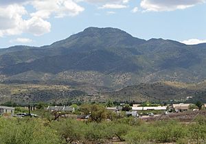
View looking up the escarpment, (from western Verde Valley)
|
|
| Highest point | |
| Peak | Woodchute Mountain |
| Elevation | 7,844 ft (2,391 m) |
| Dimensions | |
| Length | 45 mi (72 km) NW-SE |
| Width | 15 mi (24 km) |
| Geography | |
| Country | United States |
| Settlements | Clarkdale, Cottonwood, Camp Verde, Cherry (ghost town), Jerome and Cornville |
| Range coordinates | 34°44′59″N 112°10′31″W / 34.74972°N 112.17528°W |
The Black Hills of Yavapai County are a large mountain range in central Arizona. They are found in the southeast part of Yavapai County. The local Yavapai people call them Waulkayauayau, which means "pine tableland."
To the east, the range is next to the Verde Valley. A major highway, Interstate 17, cuts through the middle of the Black Hills. This highway connects big cities like Phoenix to popular places like Sedona and Flagstaff.
The northwest part of the range has a very steep slope called an escarpment. This steep area was formed by a fault-block, which is when a large block of land moves up or down along a crack in the Earth. This fault-block created the historic mining town of Jerome. The United Verde Mine in Jerome was once one of the biggest copper mines in the United States. It produced a lot of copper, gold, silver, and zinc.
The Black Hills are also the first major mountain range west of the Mogollon Rim. The Mogollon Rim is a huge cliff that marks the edge of the Colorado Plateau in Arizona. The Black Hills are part of the Arizona transition zone. This zone is a diagonal strip across central Arizona where the land changes from deserts to mountains.
Exploring the Black Hills
The Black Hills are a great place to explore nature. They have tall peaks and important wilderness areas.
What is the Highest Point?
The highest point in the Black Hills is Woodchute Mountain. It stands tall at 7,844 feet (2,391 m) (about 2,391 meters) above sea level. Another important peak, Mingus Mountain, is about 4.0 miles (6.4 km) (6.4 km) south of Woodchute Mountain. The historic town of Cherry, which is now mostly a ghost town, is about 8.7 miles (14.0 km) (14 km) further southeast.
Wilderness Areas to Discover
The Black Hills are home to three special wilderness areas. These are protected places where nature is left wild and untouched.
- The Woodchute Wilderness is in the northwest part of the range.
- The Cedar Bench Wilderness is in the southeast.
- The Pine Mountain Wilderness is also in the southeast.
These areas are perfect for hiking, camping, and enjoying the quiet beauty of nature.
 | John T. Biggers |
 | Thomas Blackshear |
 | Mark Bradford |
 | Beverly Buchanan |


