Black Peak (Washington) facts for kids
Quick facts for kids Black Peak |
|
|---|---|

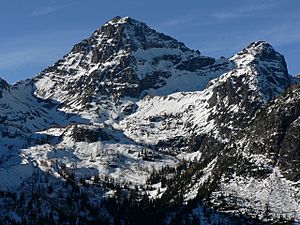
Black Peak, Washington, looking west-northwest
|
|
| Highest point | |
| Elevation | 8,975 ft (2,736 m) NAVD 88 |
| Prominence | 3,450 ft (1,050 m) |
| Isolation | 5.2 mi (8.4 km) |
| Geography | |
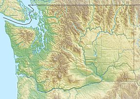
| Location | Border of Chelan and Skagit Counties, Washington, United States |
| Parent range | Cascade Range |
| Topo map | USGS Mount Arriva quadrangle |
| Climbing | |
| First ascent | 1926, Lage Wernstedt |
Black Peak is a very tall mountain in the Cascade Range in the state of Washington, United States. It is located inside the Stephen Mather Wilderness and North Cascades National Park.
Standing at 8,975 feet (2,736 m) high, Black Peak is one of the tallest mountains in Washington. It ranks as the 20th-highest peak in the state. It also stands out quite a bit from the land around it, making it the 35th-most prominent peak in Washington. The closest taller mountain is Goode Mountain, which is about 5.2 miles (8.4 km) away.
Black Peak is not a volcano. It is a popular spot for people who love to hike and camp outdoors.
Discovering Black Peak's Past
The first time someone officially climbed to the top of Black Peak was in 1926. This climb was made by Lage Wernstedt, who worked as a surveyor for the US Forest Service. He was also the one who gave the mountain its name, Black Peak.
Later, in 1983, there was an idea to change the mountain's name to "Mount Wernstedt" to honor him. However, this idea was later dropped, and the mountain kept its original name.
How Black Peak Was Formed
The North Cascades mountains, where Black Peak is located, have some really rugged and amazing shapes. You can see sharp peaks, tall granite spires, long ridges, and deep valleys carved by glaciers. These different shapes and huge changes in height happened because of geological events over millions of years. These events also led to different climates across the Cascade Range.
The story of how the Cascade Mountains formed began millions of years ago. At that time, the North American Plate (a huge piece of Earth's crust) was slowly moving over the Pacific Plate. This movement caused many volcanic eruptions and created igneous rocks.
Also, small pieces of the Earth's crust, called terranes, crashed into North America. This helped form the North Cascades about 50 million years ago.
During the Pleistocene period, which was over two million years ago, huge sheets of ice called glaciers moved across the land. They advanced and then melted back many times. As they moved, they scraped away the land, leaving behind rocks and debris. The "U"-shaped valleys you see today were carved out by these glaciers. The combination of the land being pushed up and cracks forming in the Earth (called faulting), along with the glaciers, created the tall peaks and deep valleys of the North Cascades.
Weather at Black Peak
Most of the weather systems that affect Black Peak start over the Pacific Ocean. These systems then travel northeast towards the Cascade Range. As these weather fronts get closer to the North Cascades, the tall mountains force the air to rise. When the air rises, it cools down and drops its moisture as rain or snow onto the Cascades. This process is called Orographic lift.
Because of this, the western side of the North Cascades gets a lot more rain and snow than the eastern side, especially in winter. During the winter months, the weather is often cloudy. However, in the summer, high-pressure systems over the Pacific Ocean become stronger. This often means there are very few clouds, making for clear and sunny days.
 | May Edward Chinn |
 | Rebecca Cole |
 | Alexa Canady |
 | Dorothy Lavinia Brown |


