
Blatten (Lötschen) facts for kids
Quick facts for kids
Blatten
|
||
|---|---|---|
.jpg) |
||
|
||

Blatten
Location in Switzerland

Blatten
Location in Canton of Valais
|
||
| Country | Switzerland | |
| Canton | Valais | |
| District | Westlich Raron | |
| Area | ||
| • Total | 90.51 km2 (34.95 sq mi) | |
| Elevation | 1,542 m (5,059 ft) | |
| Population
(Dec 2020 )
|
||
| • Total | 296 | |
| • Density | 3.270/km2 (8.470/sq mi) | |
| Postal code |
3919
|
|
| Surrounded by | Baltschieder, Fieschertal, Kandersteg (BE), Lauterbrunnen (BE), Naters, Raron, Wiler (Lötschen) | |

Blatten is a small village and municipality in the beautiful Lötschental valley. It is located in the canton of Valais in Switzerland. Blatten is part of the Westlich Raron district.
A big part of Blatten is inside the Jungfrau-Aletsch protected area. This area is so special that it's a World Heritage Site, recognized globally for its natural beauty. Besides the main village of Blatten, the municipality also includes smaller settlements like Eisten, Fafleralp, Ried, and Weissenried. It's important not to confuse Blatten with another village called Blatten bei Naters, which is quite far away.
Contents
History of Blatten
Blatten was first mentioned in old records way back in 1433. It was called uffen der Blattun then.
The official symbol of Blatten, its coat of arms, shows a blue shield. On the shield, there is a silver rocky mountain. At the top left, there is a silver cross with three bumps on each arm, called a "Cross bottony."
Exploring Blatten's Geography
Blatten is nestled in the Lötschental valley, south of the mighty Bernese Alps. It's the highest place where people live in the Lötschental valley, sitting at about 1,540 meters (5,052 feet) above sea level.
The municipality includes the main village of Blatten and smaller areas called hamlets: Eisten, Ried, and Weissenried. At the very end of the road in the valley, you'll find Fafleralp, which is known for its hotel.
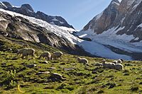
Most of Blatten is part of the Jungfrau-Aletsch protected area. This area is famous for its stunning glaciers and mountains. At the top of the Lötschental valley, the Lötschenlücke pass leads to the Aletsch Glacier. Below this pass, the Langgletscher glacier fills the valley. You can also find the beautiful Schwarzsee lake at a lower level.
Tall mountains surround the valley. The Tschingelhorn is to the north, and the Bietschhorn is to the south. Both of these impressive mountains have slopes within Blatten's municipality.
In 2011, Blatten covered an area of 90.7 square kilometers (35 square miles). About 9.5% of this land is used for farming, and 9.0% is covered by forests. Only a tiny part, 0.4%, has buildings or roads. The largest part, 81.1%, is unproductive land like mountains and glaciers.
The village of Blatten and the hamlets of Eisten and Weissenried are special. They are recognized as part of the Inventory of Swiss Heritage Sites. This means they have important historical and cultural value.
-
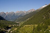
A view of the Lötschental valley with Blatten village
-
The Lötschenlücke pass and Langgletscher glacier
-
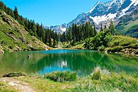
The beautiful Schwarzsee lake


Blatten's Population and People
As of 2022, Blatten has a population of 311 people. In 2008, about 51.9% of the population were men and 48.1% were women. Most people living in Blatten are Swiss citizens.
In 2000, almost everyone in Blatten (99.6%) spoke German as their main language. Children and teenagers (up to 19 years old) made up 17.8% of the population. Adults (20-64 years old) were 56.2%, and seniors (over 64 years old) were 26%.
Most people in Blatten live in private homes. In 2000, there were 114 households, with an average of 2.4 people living in each. Many apartments in Blatten are used seasonally, meaning people live there only at certain times of the year, like for holidays.
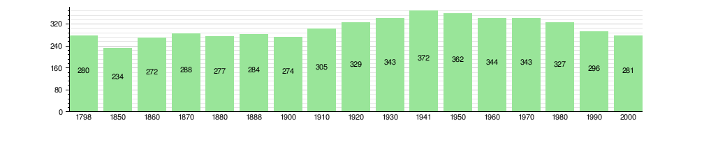
The chart below shows how Blatten's population has changed over time:
Blatten's Economy and Jobs
In 2010, Blatten had a very low unemployment rate of 1.1%. This means almost everyone who wanted a job had one.
In 2008, many people worked in the primary economic sector, which includes farming. A few people worked in the secondary sector, which is about making things, like in factories. The largest number of people worked in the tertiary sector. This sector includes jobs like working in hotels, restaurants, or shops.
Many jobs in Blatten are related to tourism, especially in hotels and restaurants. In 2000, more people left Blatten to work in other places than came into Blatten for work. About 22% of workers used public transportation, and 48% used a private car to get to their jobs.
Getting Around Blatten: Transport
Blatten is located on the main road that goes up the Lötschental valley. This road starts from Steg and Goppenstein. The road goes through Blatten village and ends at Fafleralp.
A PostAuto bus service runs along this road. It connects all the small settlements in Blatten to the Goppenstein railway station. Some buses even continue all the way to Steg.
Religion in Blatten
According to the 2000 census, most people in Blatten (98.2%) were Roman Catholic. A very small number of people did not belong to any church.
Education in Blatten
In Blatten, about 35.9% of the population has finished upper secondary education. This is education after primary school, but not yet university. A small number of people (2.5%) have gone on to higher education, like a university. In 2000, 26 students from Blatten went to schools outside the municipality.
Blatten's Climate
Blatten has a Tundra climate. This type of climate is usually found in very cold regions. It means that even in summer, the temperatures are quite cool.
| Climate data for Blatten, Lötschental (1991–2020) | |||||||||||||
|---|---|---|---|---|---|---|---|---|---|---|---|---|---|
| Month | Jan | Feb | Mar | Apr | May | Jun | Jul | Aug | Sep | Oct | Nov | Dec | Year |
| Mean daily maximum °C (°F) | 0.1 (32.2) |
1.8 (35.2) |
5.3 (41.5) |
8.8 (47.8) |
13.9 (57.0) |
18.1 (64.6) |
20.4 (68.7) |
19.8 (67.6) |
15.8 (60.4) |
11.5 (52.7) |
4.8 (40.6) |
0.4 (32.7) |
10.1 (50.2) |
| Daily mean °C (°F) | −5.4 (22.3) |
−4.4 (24.1) |
−0.4 (31.3) |
3.3 (37.9) |
8.0 (46.4) |
11.7 (53.1) |
13.4 (56.1) |
12.9 (55.2) |
9.0 (48.2) |
4.9 (40.8) |
−0.6 (30.9) |
−4.3 (24.3) |
4.0 (39.2) |
| Mean daily minimum °C (°F) | −8.8 (16.2) |
−8.9 (16.0) |
−5.1 (22.8) |
−1.4 (29.5) |
2.5 (36.5) |
5.2 (41.4) |
7.0 (44.6) |
7.0 (44.6) |
3.8 (38.8) |
0.7 (33.3) |
−3.6 (25.5) |
−7.2 (19.0) |
−0.7 (30.7) |
| Average precipitation mm (inches) | 97 (3.8) |
78 (3.1) |
77 (3.0) |
62 (2.4) |
95 (3.7) |
91 (3.6) |
93 (3.7) |
99 (3.9) |
69 (2.7) |
89 (3.5) |
93 (3.7) |
121 (4.8) |
1,064 (41.9) |
| Average precipitation days (≥ 1.0 mm) | 9.7 | 9.2 | 9.2 | 8.3 | 10.8 | 11.3 | 11.4 | 11.3 | 9.0 | 9.8 | 9.8 | 10.5 | 120.3 |
| Source: MeteoSwiss | |||||||||||||
See also
 In Spanish: Blatten para niños
