
Bohol (island) facts for kids
Quick facts for kids Bohol |
|
| Island | |
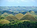
 Chocolate Hills at Carmen, Bohol
|
|
| Country | Philippines |
|---|---|
| Location | South East Asia |
| Island group | Visayas |
| Region | Central Visayas |
| Landmark | Chocolate Hills |
| Rivers | Inabanga, Loboc, Abatan, Ipil |
| Largest city | Tagbilaran |
| Area | 3,269 km² (1,262 sq mi) |
| Population | 1,255,128 (2010) |
| Density | 384 /km² (995 /sq mi) |
| Timezone | PST (UTC+8) |
| - summer (DST) | not observed (UTC+8) |
Bohol is a large island in the Philippines. It's the tenth biggest island in the country and the main part of the Bohol province. You can find it in the Central Visayas region, which is a group of islands called the Visayas.
One very special animal found here is the Philippine Tarsier. It's one of the smallest primates in the world! These tiny creatures live only in certain parts of the southern Philippines, including Bohol.
Contents
Exploring Bohol's Geography
Bohol island has an oval shape. It is surrounded by 73 smaller islands. The biggest of these small islands are Panglao and Lapining. Panglao is in the southwest, right in front of the city of Tagbilaran. Lapining is in the northeast.
The main island of Bohol covers about 3,269 square kilometers (1,262 square miles). Its coastline stretches for 261 kilometers (162 miles). Bohol is located southeast of Cebu Island, separated by the Cebu Strait. It's also southwest of Leyte, with the Camotes Sea and Canigao Channel in between. To the north of Mindanao, you'll find Bohol, with the Bohol Sea (also called Mindanao Sea) separating them.
The land in Bohol is mostly hilly. About half of the island is made of limestone. The middle part of the island is a large, flat area called a plateau.
The Famous Chocolate Hills
In the center of Bohol, especially in the towns of Sagbayan, Batuan, and Carmen, you'll find the amazing Chocolate Hills. There are over 1,270 cone-shaped hills spread across an area of about 50 square kilometers (19 square miles).
The main mountain range on the island is called Sierra Bullones. It runs along the south coast. This range starts near Loboc and goes east, then northeast, ending near Candijay. The highest point in this mountain range, and in the whole province, is Mount Mayana, which is about 870 meters (2,854 feet) tall.
Bohol's Rivers
There are four main rivers that flow through Bohol:
- Loboc River: This river starts in the center of the island and flows towards the southeastern coast.
- Inabanga River: This is the largest river on the island. It runs through the northwestern part of the province.
- Abatan River: You can find this river flowing in the southwest.
- Ipil River: This river flows in the northern part of Bohol.
Bohol's Climate
Bohol has a warm tropical climate. This means it's usually hot and wet all year round. Rainfall is often heavy and happens frequently.
Gallery
-
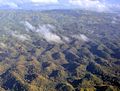
A view of Bohol's hills from above
-
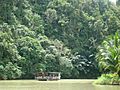
Enjoying a river cruise on the Loboc River
-
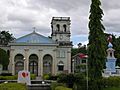
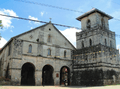
A Catholic Church in Corella, Bohol


Related pages
Images for kids
-
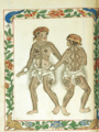
A drawing from the Boxer Codex showing the Pintados.
-
The Chocolate Hills of Bohol
-
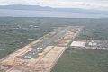
Bohol–Panglao International Airport
-
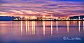
Sunset at Tagbilaran Sea Port
-
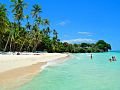
Alona beach
-
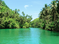
Loboc river
-
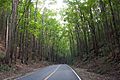
Mahogany forest in Bohol
-
Loboc
-
Baclayon church
-
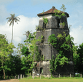
Panglao watchtower
-
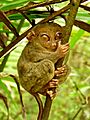
Tarsier
-
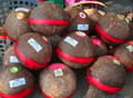
Kalamay delicacy


See also
 In Spanish: Bohol para niños
