
Bohol (province) facts for kids
The Province of Bohol (Cebuano: Lalawigan sa Bohol; Filipino: Lalawigan ng Bohol) is a beautiful island province in the Philippines. It's part of the Central Visayas region. Bohol has one big island, also called Bohol, and over 70 smaller islands around it. The main city and capital is Tagbilaran.
Bohol is a very popular place for tourists. People love its amazing beaches and resorts. The most famous sight is the Chocolate Hills. These are many small hills made of limestone that look like chocolate drops! You can find many hotels along the southern beaches.
This province is also the home of Carlos P. Garcia. He was the eighth president of the Republic of the Philippines from 1957 to 1961. He was born in Talibon.
Quick facts for kids Bohol (Filipino: Lalawigan sa Bohol) |
|||
| (Cebuano: Lalawigan ng Boho) | |||
| Province of the Philippines | |||
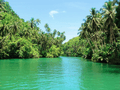
 Cruising Loboc River in a floating restaurant
|
|||
|
|||
| Country | |||
|---|---|---|---|
| Region | Central Visayas (Region VII) |
||
| Capital | Tagbilaran | ||
| Highest point | Mount Mayana | ||
| - location | Sierra Bullones, Bohol island | ||
| - elevation | 870 m (2,854 ft) | ||
| Lowest point | 0 | ||
| Area | 4,820.95 km² (1,861 sq mi) | ||
| Population | 1,255,128 (2010) | ||
| Density | 260 /km² (673 /sq mi) | ||
| Subdivisions | 47 municipalities 1109 barangays |
||
| Governor | Edgardo M. Chatto (Liberal Party) | ||
| - Vice Governor | Concepcion O. Lim (Liberal Party) | ||
| Timezone | PST (UTC+8) | ||
| ZIP code | 6300 to 6346 | ||
| ISO 3166-2 | PH-BOH | ||
| Demonym | Bolohano | ||
| Spoken languages | Cebuano (Boholano), Filipino, English | ||


Contents
History of Bohol
The first people of Bohol are believed to be the descendants of a group called pintados. This name means "tattooed ones" because they had many tattoos on their bodies.

The island first had important contact with Spain in 1565. A Spanish explorer named Miguel López de Legazpi arrived in Bohol. He was looking for spices and gold. He made a peace agreement with a local leader, Datu Sikatuna, in a place called Bool.
This agreement was sealed with a special ceremony called a blood pact. It meant they would be like "one blood." This event is known as the Sandugo. Bohol celebrates the Sandugo every year with a festival. You can also see the Sandugo shown on Bohol's provincial flag and seal.
Bohol was managed by Cebu for a while. Then, on July 22, 1854, it became its own province. In 1879, a count showed that Bohol had 253,103 people living in 34 towns. The province of Bohol was officially created on March 10, 1917.
Geography of Bohol

The Bohol island is famous for its many small hills. It has two main mountain ranges. These ranges run from the northwest to the southeast. The biggest mountain range is Sierra Bullones in the southeast. It starts near Loboc and goes east, then northeast.
The highest point in this range and the whole province is Mount Mayana. It stands about 870 m (2,850 ft) tall. In the middle of the island, there's a flat area called a plateau. This plateau has many limestone hills. In places like Carmen, Batuan, and Sagbayan, these hills are shaped almost like perfect cones. These are the famous Chocolate Hills.
Bohol has many white sandy beaches along its coast and on its smaller islands. The most well-known beaches are on Panglao Island. Many small islets nearby also have beautiful, untouched beaches.
Panglao Island
Panglao island is mostly flat, but it does have two hills. This island is known for its stunning beaches. The most famous one is Alona Beach, located on the south side of the island.
Lapinig Island
Lapinig island is northeast of the main Bohol island. It's in front of the town of Pres. Carlos P. Garcia. This island is flat, but it has hills in the middle that reach about 100 m (330 ft) high.
Rivers and Waterfalls
Bohol has four main rivers that flow across the island:
- Loboc river flows from the center of the island to the southeastern coast. It's very popular for its fun river cruises.
- Inabanga river is the largest river on the island. It runs through the northwestern part of the province.
- Abatan river flows in the southwest.
- Ipil river flows in the north.
You can also find many beautiful waterfalls and caves all over the island. One famous waterfall is the Mag-Aso falls in Antequera.
Islands of Bohol
Here are some of the islands around mainland Bohol that are part of the province:
- Alicia
- Bagatusan
- Bagong Banwa
- Balicasag
- Banacon
- Banbanan
- Bansaan
- Batasan
- Bay Sa Owak
- Bilangbilangan
- Bonbon
- Bosaan
- Buabuahan
- Bugatusan
- Busalian
- Cabilao
- Cabul-an
- Cabantulan
- Cabgan
- Calangaman
- Cancoslino
- Calituban
- Cataban
- Catang
- Cati-il
- Cuaming
- Danajon
- Gak-ang
- Gaus
- Guindacpan
- Hambongan
- Hingutanan
- Inanoran
- Jaguliao
- Jandayan
- Jao
- Juagdan
- Lapinig
- Lapinin Chico
- Limasoc
- Lumislis
- Ma-agpit
- Mahanay
- Makaina
- Makalingao
- Malingin
- Mantatao Daku
- Mantatao Gamay
- Maomauan
- Maubay
- Mocaboc
- Nasingin
- Nocnocan
- Pamasaun
- Pamilacan
- Pandanon
- Pandao
- Pangangan
- Pangapasan
- Panglao
- Pinango
- Potohan
- Pungtud
- Saag
- Sagasa
- Sandingan
- Sentingnenay
- Silo
- Sinandigan
- Tabangdio
- Talibon
- Talimobo
- Tambo
- Tangtaang
- Tintinan
- Tumok
Climate in Bohol
Bohol has a tropical climate, just like the rest of the Philippines. This means it's usually warm and humid. The dry season and wet season are quite similar.
Bohol is in the path of typhoons, which are strong storms. However, the mountains on nearby islands like Leyte, Samar, and Mindanao help protect Bohol a bit. The northeast monsoon (called Amihan) blows from November to April. During this time, the average temperatures are a little cooler. The southwest monsoon (called Habagat) blows from August to October.
| Climate data for Tagbilaran, Philippines | |||||||||||||
|---|---|---|---|---|---|---|---|---|---|---|---|---|---|
| Month | Jan | Feb | Mar | Apr | May | Jun | Jul | Aug | Sep | Oct | Nov | Dec | Year |
| Daily mean °C (°F) | 26 (79) |
26 (79) |
27 (81) |
28 (82) |
28 (82) |
28 (82) |
28 (82) |
28 (82) |
28 (82) |
28 (82) |
27 (81) |
27 (81) |
27 (81) |
| Average rainfall mm (inches) | 120 (4.7) |
50 (2.0) |
30 (1.2) |
60 (2.4) |
110 (4.3) |
80 (3.1) |
130 (5.1) |
70 (2.8) |
130 (5.1) |
130 (5.1) |
160 (6.3) |
160 (6.3) |
1,230 (48.4) |
| Source: Weatherbase.com [1] | |||||||||||||
People and Culture
The main language spoken in Bohol is Boholano. This is a special dialect of the Cebuano language. Many people also speak Tagalog and English.
Most people in Bohol are Roman Catholic. Other groups, like Protestants and followers of Iglesia ni Cristo, also live there.
Population of Bohol
In 2010, the Bohol province had a population of 1,255,128 people. This means there were about 260.3 people living in each square kilometer.
The city with the most people is the capital, Tagbilaran, with 96,792 residents. After Tagbilaran, the towns of Ubay (68,578 people) and Talibon (61,373 people) have the largest populations.
Towns and Cities
The province of Bohol is divided into 47 municipalities (towns) and 1 city. These are further divided into 1,109 smaller areas called barangays.
City
Municipalities
- Alburquerque
- Alicia
- Anda
- Antequera
- Baclayon
- Balilihan
- Batuan
- Bien Unido
- Bilar
- Buenavista
- Calape
- Candijay
- Carmen
- Catigbian
- Clarin
- Corella
- Cortes
- Dagohoy
- Danao
- Dauis
- Dimiao
- Duero
- Garcia Hernandez
- Garcia Hernandez
- Inabanga
- Jagna
- Jetafe
- Lila
- Loay
- Loboc
- Loon
- Mabini
- Maribojoc
- Panglao
- Pilar
- Pres. Carlos P. Garcia
- Sagbayan
- San Isidro
- San Miguel
- Sevilla
- Sierra Bullones
- Sikatuna
- Talibon
- Trinidad
- Tubigon
- Ubay
- Valencia
Gallery
-
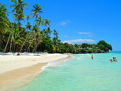
Alona beach
-
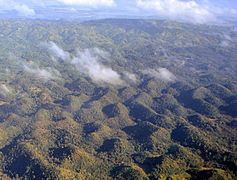
Bohol interior
-
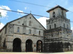
Baclayon church
-
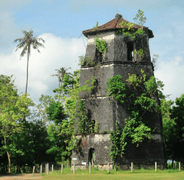
Panglao watchtower


Images for kids
-
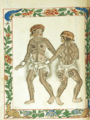
A drawing from the Boxer Codex depicting the Pintados.
-
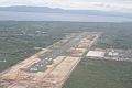
Bohol–Panglao International Airport
-
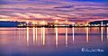
Sunset at Tagbilaran Sea Port
-
Loboc river
-
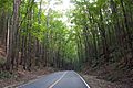
Mahogany forest in Bohol
-
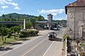
Loboc
-
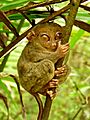
Tarsier
-
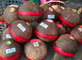
Kalamay delicacy


See also
 In Spanish: Bohol para niños
