Borley facts for kids
Quick facts for kids Borley |
|
|---|---|
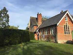
 Borley Village Hall |
|
| OS grid reference | TL850431 |
| District |
|
| Shire county | |
| Region | |
| Country | England |
| Sovereign state | United Kingdom |
| Post town | SUDBURY |
| Postcode district | CO10 |
| Dialling code | 01787 |
| Police | Essex |
| Fire | Essex |
| Ambulance | East of England |
| EU Parliament | East of England |
| UK Parliament |
|
Borley is a small village in the countryside of northern Essex, England. It's very close to the border with Suffolk. You can find it near the River Stour. The nearest town is Sudbury, Suffolk, which is about 3 kilometers (2 miles) away to the southeast. Sudbury is also the main postal town for Borley. Nearby villages include Foxearth, Belchamp Walter and Bulmer.
Contents
A Look at Borley's Past
The name Borley might come from old words. Some think it means "Boar's Pasture" from Saxon times. Others believe it comes from a Celtic word, 'borle', which means 'summer meadows'. These beautiful meadows are still a big part of the area today.
Borley in the Domesday Book
In the 11th century, Borley was a "manor." A manor was like a large estate with land and buildings. The Domesday Book, a famous record from 1086, shows that Borley manor was owned by Adeliza, Countess of Albemarle. She was the half-sister of William the Conqueror, who became King of England. Later, the manor was given to King Edward I.
Life in Medieval Borley
A document from 1308 tells us about the people living in Borley. It lists 46 people, including:
- Seven "free tenants" who owned their land.
- Seven "molmen" who paid rent.
- 27 "villeins" who worked the land for the lord.
- Five "cotemen" who had small cottages.
Historians think about 230 people lived in Borley at that time. In 1346, the manor of Borley was given to a religious group called the priory of Christ Church in Canterbury.
The Waldegrave Family and Borley
From the 1500s, the Waldegraves were an important family in Borley. They were a leading Catholic family in Essex. Sir Edward Waldegrave, who worked for Queen Mary, bought Borley manor in 1546. It became his main home. He later died in the Tower of London in 1561. This happened because he was no longer favored by Queen Elizabeth. His wife, Lady Frances Neville, later built a special monument for him and herself in Borley Church.
Borley's Environment and Buildings
Borley is made up of three groups of buildings:
- One group is near the River Stour, where the village hall is.
- Another group is around the local church.
- A third group is at Borley Green.
In 2012, about 110 people lived in Borley, in 49 homes. Many of Borley's buildings are "Listed Buildings." This means they are special and protected because of their history or architecture. There are 15 Grade II listed houses, including Borley Hall and Borley Place.
Borley Church
The church in Borley is a Grade I listed building. It's a small stone church that was built a long time ago, in the late 1100s and early 1200s. One interesting thing about the church is a "topiary walk" leading to its entrance. Topiary means plants that are trimmed into decorative shapes.
Borley's Countryside
Borley is considered a "countryside" area. This means it's mostly open land, not a busy town. Borley Green is a grassy area owned by the local council. The village is part of the South Suffolk and North Essex Clayland area. This area is known for its old landscape with woods and farms, giving it a feeling of being enclosed and natural.
 | Ernest Everett Just |
 | Mary Jackson |
 | Emmett Chappelle |
 | Marie Maynard Daly |


