
Braunton Burrows facts for kids
| Site of Special Scientific Interest | |

Flagpole Dune - A major blowout encouraged to feed sand into the surrounding area.
|
|
| Area of Search | North Devon |
|---|---|
| Coordinates | 51°05′49″N 4°12′47″W / 51.097°N 4.213°W |
| Interest | Biological and Geological |
| Area | 1,356.7 hectares (13.567 km2; 5.238 sq mi) |
| Notification | 1952 (part) 1969 (full) |
Braunton Burrows is a huge area of sand dunes on the coast of North Devon, England. It is the largest sand dune system in England. This special place is owned by the Christie Devon Estates Trust.
Braunton Burrows is very important for nature. It has many different types of dune plants, with over 400 kinds of vascular plants. These are plants that have special tissues to carry water and nutrients. The grassy areas are full of lichens and herbs. The wet, low areas between dunes, called dune slacks, are also very rich in plant life. Many rare plants and animals live here. For example, the Amber Sandbowl Snail is found in only two places in the UK, and this is one of them!
Contents
History of Braunton Burrows
A historian named Tristram Risdon wrote about Braunton Burrows way back in the 1600s. He said that the sand had covered many hundreds of acres of land. People used to dig sand from a hill to put on their farms. One day, a lot of sand fell down, showing the top of a tree. They found the tree was 30 feet long! This showed that the area, now covered by sand dunes, used to be a forest with tall trees.
Similar stories exist across the Bristol Channel in Glamorgan, Wales. There, the Merthyr Mawr Sand Dunes started moving in the late 1300s. They even covered Kenfig Castle, forcing people to leave it.
Civilian Uses of the Burrows
A lifeboat station opened at Braunton Burrows in 1848. The crew came from the nearby Appledore Lifeboat Station. It closed in 1918 because it was hard to find people and horses to launch the boat after World War I.
Today, local people use Braunton Burrows for fun activities. Many people enjoy walking their dogs there. Scientists also come to study the plants, especially the rare ones. In summer, tourists visit the area. Some quiet parts of the Burrows are used for relaxing outdoors.
Military Training at Braunton Burrows
Braunton Burrows played a big part during World War II. In 1943, an American officer named Paul W. Thompson needed a place to train US soldiers. These soldiers were preparing for the D-Day landings on the beaches of Normandy, France.
All the best training spots were already being used by the British. So, Thompson had to choose the Atlantic coast near Braunton. The land he needed stretched from Mortehoe Station to Braunton. It also went from the River Caen to the Taw Torridge Estuary. Every bit of land was used for practice. Soldiers used live ammunition, explosives, tanks, artillery, and even air support. This area became the US Assault Training Centre.
The beaches here were perfect for practicing landings from the sea, even with the strong Atlantic waves. The sand was just like the sand at Omaha Beach in Normandy. Anyone who has seen Omaha Beach will notice how much it looks like Woolacombe and Saunton.
Thompson's first job was to teach troops how to get past enemy defenses on the beach. Later, the training for fighting inland moved to Slapton beach in South Devon.
They needed firing ranges for all the weapons. These ranges and other training aids had to be built quickly. The first soldiers arrived in North Devon on September 1, 1943. You can still find six concrete replica landing craft at the southern end of the Burrows. These were built for practice.
As winter came, a permanent camp was needed. Most troops had been living in tents. So, 505 Nissen huts were built to house 4,250 men.
Some narrow country roads were made one-way to make travel easier. Where there were no paved roads, temporary tracks were laid. One of these tracks was an old ferry path. It went from the south end of Sandy Lane, behind the dunes, to the White House near Crow Point. This road was made wider and straighter. Today, it is known as ‘the American Road’.
The Ministry of Defence still uses the site today. They lease it from the Christie Devon Estates Trust. The area is closed for 10 days each year for military training. It is hard to get around, which makes it great for land-based exercises. The sandy conditions are also useful for many types of training. The Royal Air Force sometimes uses Saunton Sands to practice short take-off and landing (STOL) with their Lockheed C-130 Hercules planes. The Royal Marines also practice landing on the beach from the sea.
Crow Point Lighthouse
 |
|
| Crow Point Lighthouse | |

Crow Point Lighthouse
Location in Devon
|
|
| Location | Appledore Devon England |
|---|---|
| Coordinates | 51°03′58″N 4°11′23″W / 51.06616°N 4.18980°W |
| Year first constructed | 1954 |
| Construction | metal skeletal tower |
| Tower shape | square pyramidal tower with balcony and light |
| Markings / pattern | white tower |
| Height | 5 m (16 ft) |
| Focal height | 7.6 m (25 ft) |
| Current lens | 300mm fixed drum lens |
| Intensity | 182 candela |
| Range | 6 nmi (11 km) |
| Characteristic | Fl WR 2.5s. |
| Admiralty number | A5612 |
| NGA number | 6240 |
| ARLHS number | ENG 030 |
At the southern end of Braunton Burrows is Crow Point Lighthouse. This lighthouse helps ships find their way through the Taw and Torridge estuary. It was built in 1954. The lighthouse is a small steel tower. It was first powered by gas, then by electricity in 1978, and now by solar power since 1987. It was updated in 2001. It now shows a special light that tells ships where it is safe to go in and out of the River Taw. Trinity House operates it.
A much bigger lighthouse used to stand nearby, called Braunton Lighthouse (or Bideford Lighthouse). It was an 86-foot-tall wooden tower built on top of the keepers' homes. There was also a smaller "low light" 300 meters away. When a ship in Bideford Bay saw both lights lined up, it meant they were on a safe path through the sandbanks in the estuary. The low light was on a short railway. It could be moved to keep up with the shifting sandbanks. For example, between 1820 and 1832, it had to be moved 34 meters northeast!
Both lighthouses were built in 1819. They were painted white and had a single bright light. In the 1800s, the lights were only on when the tide was high enough for ships to pass safely over the Bideford Bar, a dangerous sandbank. From 1879, the main light stayed on all night. In 1889, it started to flash, turning off for two seconds every thirty seconds. The low light still only showed when the tide was right. Later, a red or green light was added to show the tide, and a round shape was used during the day. In 1890, both lighthouses were painted with a red stripe facing the sea.
In 1945, the two lighthouse keepers left because the ground under the main lighthouse was becoming unsafe. After Crow Point Light was built, both old Braunton lights were taken down in 1957. New guiding lights were then put up east of the estuary, at Instow.
Special Designations
Braunton Burrows is recognized as a very important natural area. It has several special designations:
- UNESCO Biosphere Reserve
- National nature reserve (part of it)
- SSSI
- Ramsar site (important wetlands)
- Special Area of Conservation
- North Devon AONB (Area of Outstanding Natural Beauty)
- North Devon Heritage Coast
Part of the site stopped being a National Nature Reserve in 1996. This happened because the landowner, Christie Devon Estates Trust, and English Nature disagreed about how to manage the grazing animals. This was the only time a site had its NNR status removed.
Braunton Burrows is the main part of North Devon's Biosphere Reserve.
Managing Plant Growth
People manage the growth of bushes and trees to keep the sand dunes healthy. They want to stop the area from becoming a forest. The ways they manage this growth have caused some disagreements among the groups involved.
In the 1970s, rabbits helped control the growth of tough grasses by eating them. But then a disease called myxomatosis caused the rabbit population to drop. This led to more bushes like privet and heather growing over the grassy areas. The number of different plant species went down. This problem got worse when the military introduced sea buckthorn. They did this to try and stop the sand from moving after the Normandy landings preparations caused a lot of erosion. Deep-rooted plants like bramble, hawthorn, and willow also grew a lot. These plants were later controlled, and the diverse grassy areas grew back using different methods.

Burning some deep-rooted plants made the soil more fertile, but it also helped tough grasses spread. These grasses were later managed by mowing and by letting soay sheep and cattle graze.
The Christie Estates Trust thought that grazing caused more erosion and harmed the different plant species. So, they were against bringing sheep and cattle to the site. However, English Nature felt that while grazing caused some sand movement, it was better than mowing. English Nature believed that the movement of soil increased the variety of species. They also thought that using soay sheep helped keep the ecosystems balanced. This disagreement was the main reason why the site lost its status as a national nature reserve in 1996.
Images for kids
-
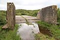
Concrete replica Landing craft built in 1943 for practice before D-Day
-
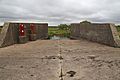
Braunton Burrows concrete landing craft with memorial plaque


See also
 In Spanish: Braunton Burrows para niños
