Bideford Bay facts for kids
Quick facts for kids Bideford Bay |
|
|---|---|

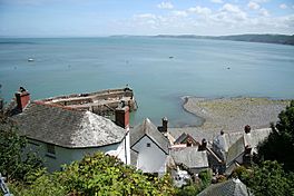
View over Bideford Bay, looking north-eastwards from Clovelly towards Baggy Point
|
|
| Coordinates | 51°04′N 4°20′W / 51.067°N 4.333°W |
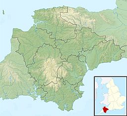
Bideford Bay, also known as Barnstaple Bay, is a large area of water on the northwest coast of Devon in South West England. It's where the Bristol Channel meets the Celtic Sea. This bay stretches from Hartland Point in the southwest to Baggy Point in the northeast. The island of Lundy, about 12 miles (19 km) offshore, helps to shelter the bay. The bay gets its names from the towns of Bideford and Barnstaple. These towns are located on the rivers Torridge and Taw, which both flow into the bay.
Exploring the Coastline of Bideford Bay
The coastline of Bideford Bay is very interesting and changes a lot from one end to the other.
Steep Cliffs and Hidden Villages
East of Hartland Point, the coast has steep, rocky cliffs. These cliffs are often covered in trees. There are no natural harbours here, and not many people live in this part of the bay.
One special place is the small village of Clovelly. It used to be a fishing village and is now a popular spot for tourists. It has a harbour that was built by people.
Further east, you'll find the village of Westward Ho!. Here, you can see a clear raised beach platform. This means that at some point in the past, the sea level was much higher. The waves cut this platform into the land.
Ancient Forests and Sandy Shores
At the southern end of Westward Ho! Beach, there's a submerged forest. You can find peat deposits there. This shows that about 6,000 years ago, the sea level rose and covered a forest that used to be on the coast.
North of Westward Ho!, the coast changes. Instead of cliffs, you'll find long, sandy beaches. Behind these beaches are large systems of sand dunes.
The rivers Taw and Torridge meet and flow into the bay between two dune systems: Northam Burrows and Braunton Burrows.
Northam Burrows Country Park
The Northam Burrows area is managed as a country park. It's a grassy coastal plain with a shingle ridge and a spit. These features were formed by a process called longshore drift, where sand and pebbles are moved along the coast by waves.
Braunton Burrows: A Wildlife Haven
Braunton Burrows is one of the biggest sand dune systems in Britain. It's over 3 miles (5 km) long and 1 mile (2 km) wide. It sits behind the wide, sandy beach of Saunton Sands. These dunes are very important for their wildlife, including some rare plants and animals. They are so important that they form the main part of a Biosphere Reserve.
Northern Headlands and Surfing Spots
The northern part of the bay's coast includes popular places for surfing and tourism. These are Croyde Bay and Morte Bay, which includes Woolacombe. These are smaller bays with beaches nestled between steep headlands like Saunton Down, Baggy Point, and Morte Point.
The coastline between Saunton Sands and Baggy Point has cliffs that can reach up to 200 feet (61 m) high. These cliffs are made of different types of rock, including Devonian sandstones, shales, slates, and limestones. Many of these rocks show amazing folding, which means they have been bent and twisted by powerful forces over millions of years.
You can also find raised beaches here with large erratic boulders. These are huge rocks that were carried to the area by glaciation (ice sheets). For example, there's a 12-tonne pink granite boulder at Saunton that scientists believe came all the way from northwest Scotland!
Protecting Bideford Bay's Beauty
The beautiful coastal landscape of Bideford Bay is very important, so it has special protections.
North Devon Area of Outstanding Natural Beauty
The core of this coast is part of the North Devon AONB. AONB stands for "Area of Outstanding Natural Beauty." This special title helps protect the natural beauty of the area. It also includes parts of the Devon coast to the east and west of the bay.
Heritage Coasts
A large part of this coast has also been named a North Devon and Hartland Heritage Coast. This designation helps to preserve the natural and cultural heritage of the coastline.
Walking the South West Coast Path
The popular national trail, the South West Coast Path, runs along the entire length of Bideford Bay. This means you can walk along the coast and enjoy all the amazing views.
There are car parks for visitors at many places along the bay, including Croyde, Saunton, Braunton Burrows, Northam Burrows, Westward Ho!, and Clovelly.


