Bridgewater, New York facts for kids
Quick facts for kids
Bridgewater
|
|
|---|---|

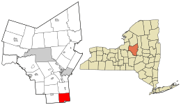
Location in Oneida County and the state of New York.
|
|

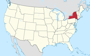
Location of New York in the United States
|
|
| Country | United States |
| State | New York |
| County | Oneida |
| Area | |
| • Total | 23.86 sq mi (61.79 km2) |
| • Land | 23.84 sq mi (61.76 km2) |
| • Water | 0.01 sq mi (0.03 km2) |
| Population
(2010)
|
|
| • Total | 1,522 |
| • Estimate
(2016)
|
1,492 |
| • Density | 62.57/sq mi (24.16/km2) |
| Time zone | UTC-5 (EST) |
| • Summer (DST) | UTC-4 (EDT) |
| FIPS code | 36-065-08180 |
Bridgewater is a small town in Oneida County, New York, United States. In 2010, about 1,522 people lived there.
The Town of Bridgewater is located on the southern edge of Oneida County. There is also a smaller community, a hamlet, called Bridgewater within the town. Both the town and the hamlet are named after the Duke of Bridgewater.
Contents
History of Bridgewater
The first people settled in the area around 1788. The Town of Bridgewater was officially formed in 1797. It was created from a nearby area called the Town of Sangerfield.
A notable event in Bridgewater's history happened in 1974. That year, Everett Holmes was elected mayor. He was the first African American mayor elected in New York State.
Geography of Bridgewater
Bridgewater covers an area of about 23.9 square miles (61.8 square kilometers). All of this area is land.
U.S. Route 20 runs through the southern part of the town. This major road crosses New York State Route 8 here.
The southern border of the town touches Madison County and Otsego County. The eastern border of the town is shared with Herkimer County.
Population of Bridgewater
| Historical population | |||
|---|---|---|---|
| Census | Pop. | %± | |
| 1800 | 1,061 | — | |
| 1810 | 1,170 | 10.3% | |
| 1820 | 1,533 | 31.0% | |
| 1830 | 1,608 | 4.9% | |
| 1840 | 1,418 | −11.8% | |
| 1850 | 1,308 | −7.8% | |
| 1860 | 1,261 | −3.6% | |
| 1870 | 1,258 | −0.2% | |
| 1880 | 1,218 | −3.2% | |
| 1890 | 1,073 | −11.9% | |
| 1900 | 931 | −13.2% | |
| 1910 | 832 | −10.6% | |
| 1920 | 746 | −10.3% | |
| 1930 | 730 | −2.1% | |
| 1940 | 743 | 1.8% | |
| 1950 | 806 | 8.5% | |
| 1960 | 966 | 19.9% | |
| 1970 | 1,251 | 29.5% | |
| 1980 | 1,455 | 16.3% | |
| 1990 | 1,591 | 9.3% | |
| 2000 | 1,671 | 5.0% | |
| 2010 | 1,522 | −8.9% | |
| 2016 (est.) | 1,492 | −2.0% | |
| U.S. Decennial Census | |||
In 2000, there were 1,671 people living in Bridgewater. There were 596 households, which are groups of people living together. Out of these, 454 were families.
About 42.1% of the households had children under 18 living with them. The average household had 2.80 people. The average family had 3.12 people.
Looking at age groups in 2000:
- 31.1% of the population was under 18 years old.
- 7.8% was between 18 and 24 years old.
- 31.7% was between 25 and 44 years old.
- 21.2% was between 45 and 64 years old.
- 8.2% was 65 years or older.
The median age in Bridgewater was 34 years. This means half the people were younger than 34 and half were older.
Communities and Locations
The Town of Bridgewater includes several smaller communities and important places:
- Babcock Hill – This is a small hamlet located in the northeastern part of the town.
- Bridgewater – This hamlet is on US Route 20, near the southern border of the town. It used to be an official village but stopped being one in 2014.
- Hobin Corners – Another hamlet found near the western town line, also on US Route 20.
- Mapledale – This hamlet is located closer to the center of the town.
- North Bridgewater – A hamlet in the northern part of the town, located on New York State Route 8.
- Tassel Hill – This is the highest point in Oneida County. It is in the northwest part of the town. Tassel Hill is also on the borders of the towns of Marshall, Paris, and Sangerfield.
See also
 In Spanish: Bridgewater (Nueva York) para niños

