
Brinkley, Arkansas facts for kids
Quick facts for kids
Brinkley, Arkansas
|
|
|---|---|
|
City
|
|

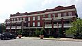
Downtown Brinkley
|
|

Location in Monroe County, Arkansas
|
|
| Country | United States |
| State | Arkansas |
| County | Monroe |
| Area | |
| • Total | 6.14 sq mi (15.91 km2) |
| • Land | 5.69 sq mi (14.73 km2) |
| • Water | 0.46 sq mi (1.18 km2) |
| Elevation | 200 ft (60 m) |
| Population
(2020)
|
|
| • Total | 2,700 |
| • Density | 474.85/sq mi (183.35/km2) |
| Time zone | UTC-6 (Central (CST)) |
| • Summer (DST) | UTC-5 (CDT) |
| ZIP code |
72021
|
| Area code(s) | 870 |
| FIPS code | 05-08950 |
| GNIS feature ID | 2403926 |
Brinkley is a city in Monroe County, Arkansas, United States. It is the largest city in the county. In 2020, about 2,700 people lived there. This was a bit less than the 3,188 people who lived there in 2010.
Brinkley is located in the Arkansas Delta region. It started as a railroad town in 1872. For a long time, it has been a key place for transportation and farming in the area. More recently, Brinkley has become known for outdoor activities and for the ivory-billed woodpecker. Birding (watching birds) became very important after people thought they saw the ivory-billed woodpecker in 2004. This bird was believed to be extinct for 60 years!
The city is located right between Little Rock and Memphis. Because of this, Brinkley sometimes uses the slogan "We'll Meet You Half-Way" in its ads.
Contents
History of Brinkley
In 1852, a special land grant was given to build railroad lines. This project was led by Robert Campbell Brinkley, who was the president of the Little Rock and Memphis Railroad Company. Robert C. Brinkley was from North Carolina but lived in Memphis. He was known for his "noble deeds and generous conduct" and was also a bank president for many years.
Early Days as "Lick Skillet"
Before it was called Brinkley, the settlement was known as "Lick Skillet" from 1852 to 1869. The railroad workers, who were mostly immigrants from nearby towns, would cook their dinner over an open fire after a day's work. They would then go home when the last "skillet was licked" clean.
Founding of the Railroad Town
The building of the railroad lines between Little Rock and Memphis led to the creation of Brinkley. The city is in the northern part of Monroe County. It was chosen as the halfway point between the two larger cities. The town was planned out in the winter of 1869 on land owned by the railroad company.
Brinkley officially became a town on August 6, 1872. At that time, about 50 people were old enough to vote there. The first official document for the town was filed on August 21, 1872. Other railroads also came through Brinkley. The Cotton Plant Railroad started from Brinkley in 1879. The Texas and St. Louis Railway was built through the city in 1883. Later, the Brinkley, Helena and Indian Bay Railway connected to the town around 1889.
The 1909 Tornado
On March 8, 1909, a very powerful F4 tornado hit Brinkley. It caused a lot of damage to the town. Many families were affected, and about 800 buildings were destroyed. The tornado was very wide, about two-thirds of a mile across.
Duck Hunting in Brinkley
Duck hunting is a very important activity for Brinkley. It brings a lot of money to the city during November, December, and January. Many rice fields in the area are flooded for the winter. This makes the region a great place for ducks, as Brinkley is on the Mississippi Flyway. People from all over the United States come to Brinkley for guided duck hunts during the season.
Geography and Climate
Brinkley is located in northern Monroe County. It is about 69 miles (111 km) east of Little Rock, which is the capital of Arkansas. It is also about 72 miles (116 km) west-southwest of Memphis, Tennessee.
Roads and Highways
U.S. Routes 70 and 49 meet in Brinkley and are called Main Street. US 70 then turns east onto Cypress Street in the center of town. US 70 goes east-northeast about 5 miles (8 km) to Wheatley. It goes west-southwest about 14 miles (23 km) to Biscoe. US 49 goes north-northeast about 74 miles (119 km) to Jonesboro. It goes southeast about 51 miles (82 km) to Helena-West Helena. The city limits of Brinkley stretch north along US 49 to where it meets Interstate 40. Interstate 40 connects Memphis and Little Rock.
Land and Water
The United States Census Bureau says that Brinkley covers a total area of 6.14 square miles (15.91 km²). Most of this area, 5.69 square miles (14.73 km²), is land. The rest, 0.46 square miles (1.18 km²), is water.
Brinkley's Climate
The weather in Brinkley has hot, humid summers. The winters are usually mild to cool. According to the Köppen Climate Classification system, Brinkley has a humid subtropical climate. This means it has warm temperatures and plenty of rain throughout the year.
| Climate data for Brinkley, Arkansas (1991–2020 normals, extremes 1883–2017) | |||||||||||||
|---|---|---|---|---|---|---|---|---|---|---|---|---|---|
| Month | Jan | Feb | Mar | Apr | May | Jun | Jul | Aug | Sep | Oct | Nov | Dec | Year |
| Record high °F (°C) | 80 (27) |
85 (29) |
92 (33) |
99 (37) |
100 (38) |
110 (43) |
111 (44) |
110 (43) |
109 (43) |
97 (36) |
90 (32) |
82 (28) |
111 (44) |
| Mean maximum °F (°C) | 67.8 (19.9) |
72.8 (22.7) |
78.5 (25.8) |
84.5 (29.2) |
89.7 (32.1) |
94.7 (34.8) |
97.5 (36.4) |
98.0 (36.7) |
94.4 (34.7) |
87.1 (30.6) |
78.7 (25.9) |
68.7 (20.4) |
99.7 (37.6) |
| Mean daily maximum °F (°C) | 47.8 (8.8) |
52.7 (11.5) |
61.3 (16.3) |
70.9 (21.6) |
79.6 (26.4) |
87.2 (30.7) |
90.1 (32.3) |
89.9 (32.2) |
83.9 (28.8) |
73.6 (23.1) |
60.6 (15.9) |
51.3 (10.7) |
70.7 (21.5) |
| Daily mean °F (°C) | 39.2 (4.0) |
43.2 (6.2) |
51.4 (10.8) |
60.7 (15.9) |
69.9 (21.1) |
78.1 (25.6) |
81.1 (27.3) |
80.0 (26.7) |
73.2 (22.9) |
62.2 (16.8) |
50.5 (10.3) |
42.4 (5.8) |
61.0 (16.1) |
| Mean daily minimum °F (°C) | 30.6 (−0.8) |
33.7 (0.9) |
41.5 (5.3) |
50.6 (10.3) |
60.3 (15.7) |
69.0 (20.6) |
72.0 (22.2) |
70.1 (21.2) |
62.6 (17.0) |
50.7 (10.4) |
40.5 (4.7) |
33.5 (0.8) |
51.3 (10.7) |
| Mean minimum °F (°C) | 14.4 (−9.8) |
18.6 (−7.4) |
27.0 (−2.8) |
35.7 (2.1) |
47.3 (8.5) |
58.1 (14.5) |
64.2 (17.9) |
61.6 (16.4) |
46.9 (8.3) |
36.1 (2.3) |
27.0 (−2.8) |
18.7 (−7.4) |
10.9 (−11.7) |
| Record low °F (°C) | −10 (−23) |
−12 (−24) |
10 (−12) |
23 (−5) |
31 (−1) |
39 (4) |
45 (7) |
44 (7) |
30 (−1) |
20 (−7) |
10 (−12) |
−7 (−22) |
−12 (−24) |
| Average precipitation inches (mm) | 3.78 (96) |
4.09 (104) |
4.98 (126) |
5.56 (141) |
6.27 (159) |
3.51 (89) |
3.33 (85) |
3.14 (80) |
2.96 (75) |
3.97 (101) |
4.52 (115) |
5.08 (129) |
51.19 (1,300) |
| Average snowfall inches (cm) | 0.7 (1.8) |
1.1 (2.8) |
0.8 (2.0) |
0.0 (0.0) |
0.0 (0.0) |
0.0 (0.0) |
0.0 (0.0) |
0.0 (0.0) |
0.0 (0.0) |
0.0 (0.0) |
0.1 (0.25) |
0.0 (0.0) |
2.7 (6.9) |
| Average precipitation days (≥ 0.01 in) | 8.3 | 6.8 | 8.3 | 7.9 | 9.3 | 6.1 | 6.2 | 4.2 | 4.9 | 6.5 | 7.9 | 7.8 | 84.2 |
| Average snowy days (≥ 0.1 in) | 0.3 | 0.8 | 0.2 | 0.0 | 0.0 | 0.0 | 0.0 | 0.0 | 0.0 | 0.0 | 0.0 | 0.1 | 1.4 |
| Source: NOAA (mean maxima/minima 1981–2010) | |||||||||||||
Population of Brinkley
| Historical population | |||
|---|---|---|---|
| Census | Pop. | %± | |
| 1880 | 327 | — | |
| 1890 | 1,510 | 361.8% | |
| 1900 | 1,648 | 9.1% | |
| 1910 | 1,740 | 5.6% | |
| 1920 | 2,714 | 56.0% | |
| 1930 | 3,046 | 12.2% | |
| 1940 | 3,409 | 11.9% | |
| 1950 | 4,173 | 22.4% | |
| 1960 | 4,636 | 11.1% | |
| 1970 | 5,275 | 13.8% | |
| 1980 | 4,909 | −6.9% | |
| 1990 | 4,232 | −13.8% | |
| 2000 | 3,940 | −6.9% | |
| 2010 | 3,188 | −19.1% | |
| 2020 | 2,700 | −15.3% | |
| U.S. Decennial Census 2014 Estimate |
|||
2020 Census Information
The 2020 United States Census counted 2,700 people living in Brinkley. There were 1,179 households and 759 families in the city.
| Race | Num. | Perc. |
|---|---|---|
| White | 1,107 | 41.0% |
| Black or African American | 1,390 | 51.48% |
| Native American | 5 | 0.19% |
| Asian | 20 | 0.74% |
| Pacific Islander | 1 | 0.04% |
| Other/Mixed | 129 | 4.78% |
| Hispanic or Latino | 48 | 1.78% |
Arts, Culture, and Tourism

Brinkley is a great place for tourism, especially for nature lovers.
Nature and Wildlife
Brinkley is located about 10 miles (16 km) east of the Cache River National Wildlife Refuge. In February 2004, people thought they saw the ivory-billed woodpecker there. This was very exciting because the bird was believed to be extinct for over 60 years! Brinkley has tried to use this discovery to attract visitors.
Besides the ivory-billed woodpecker sightings, at least two bald eagle nests have been found in the Monroe County area since July 2005. Also, the swamps of the Cache River are thought to have some of the oldest cypress trees in the United States.
Convention Center
Brinkley opened a convention center in 1996. It can hold up to 600 people. In February 2006, the center hosted a conference. This event celebrated the second anniversary of the ivory-billed woodpecker's rediscovery.
Education in Brinkley

Students in Brinkley get their public education from the Brinkley School District. This district helps students from elementary school all the way through high school. Students graduate from Brinkley High School.
City Infrastructure

Brinkley has always been important for transportation. It continues to be a key location for major roads.
Transportation Hub
Brinkley is in Monroe County, in the rich farmlands of the Arkansas Delta. It is a convenient stop for travelers on Interstate 40 (I-40). I-40 is one of the busiest interstates in the United States. The city is also on U.S. Route 49 (US 49), which goes north and south. US 70 is another important road that goes east and west through the city.
Bus service to Brinkley is provided by Jefferson Lines.
Famous People from Brinkley
Many notable people have connections to Brinkley:
- Dorathy M. Allen was the first woman elected to the Arkansas Senate.
- Al Bell is a famous record producer, songwriter, and music executive.
- Curtis Burrow played for the Green Bay Packers football team.
- Jerry Eckwood was a football player for the Arkansas Razorbacks and the Tampa Bay Buccaneers.
- John Handcox was a Great Depression-era farmer and union supporter. He was known for his songs and poems about politics.
- Betty Cooper Hearnes was a state representative in Missouri.
- Louis Jordan, born in Brinkley, was a jazz and early rock & roll musician. He is in the Rock and Roll Hall of Fame.
- Herbert "Flight Time" Lang is a current member of the Harlem Globetrotters basketball team. He also appeared three times on The Amazing Race.
- Tommy Robinson was a former sheriff and congressman.
See also
 In Spanish: Brinkley (Arkansas) para niños
Images for kids
-
Rusher Hotel, a railroad hotel next to the station

