Brooklyn Center, Minnesota facts for kids
Quick facts for kids
Brooklyn Center, Minnesota
|
||
|---|---|---|

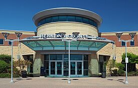
Hennepin County District Court in Brooklyn Center
|
||
|
||
| Motto(s):
At The Center
|
||

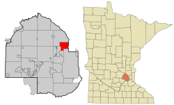
Location of the city of Brooklyn Center
within Hennepin County, Minnesota |
||
| Country | United States | |
| State | Minnesota | |
| County | Hennepin | |
| Settled | 1852 | |
| Incorporated (village) | February 18, 1911 | |
| Incorporated (city) | October 20, 1966 | |
| Area | ||
| • Total | 8.381 sq mi (21.707 km2) | |
| • Land | 8.003 sq mi (20.728 km2) | |
| • Water | 0.378 sq mi (0.979 km2) | |
| Elevation | 856 ft (261 m) | |
| Population
(2020)
|
||
| • Total | 33,782 | |
| • Estimate
(2022)
|
32,217 | |
| • Density | 4,025.0/sq mi (1,554.0/km2) | |
| Time zone | UTC−6 (Central (CST)) | |
| • Summer (DST) | UTC−5 (CDT) | |
| ZIP Codes |
55429, 55430
|
|
| Area code(s) | 763 | |
| FIPS code | 27-07948 | |
| GNIS feature ID | 0640508 | |
| Sales tax | 8.525% | |
Brooklyn Center is a city in Hennepin County, Minnesota, United States. It's part of the larger Minneapolis–Saint Paul area. In 1911, this area became a village. It was formed from parts of Brooklyn Township and Crystal Lake Township. Later, in 1966, Brooklyn Center officially became a city.
The city has many businesses and industries. Most of the land is used for single-family homes. In 2020, about 33,782 people lived here. Brooklyn Center is known for being the most diverse community in Minnesota.
Contents
History of Brooklyn Center
Pioneers started organizing local governments for Brooklyn Township and Crystal Lake Township in 1858. This was when Minnesota became a state. Osseo Road was a main path for settlers. They built their community around a school, post office, store, meeting hall, and churches. This area grew as a place where people farmed and sold produce. It was also close to the growing city of Minneapolis.
To protect their community from being taken over by Minneapolis, residents decided to form a village. They wanted simpler local rules and more police protection. On January 16, 1911, the Hennepin County Board approved their request. An election was held, and the village boundaries were set. Brooklyn Center officially became a village on February 18, 1911. P.W. Reidhead was the first president. About 500 people lived there at that time.
By 1940, the village needed better planning for things like sewage and traffic. A Planning Commission was created in 1942. Farmers began selling their land to developers for new homes. The population grew very quickly, reaching 4,000 by 1950. A new shopping center called Brookdale opened in 1960. By then, the population had grown to over 24,000 people.
The Heritage Center of Brooklyn Center used to be the country estate of Earle Brown. It was built in 1878. The estate included the family home, offices, barns, and even a hippodrome. Today, it is a historic site owned by the city. It is used as a conference and event center.
In April 2021, a sad event happened in the city. A young man named Daunte Wright was killed by a police officer. This led to protests and community unrest in the city. Later, the city worked with a group called Juxtaposition Arts to create a permanent memorial for Daunte Wright.
Geography of Brooklyn Center
Brooklyn Center covers about 8.38 square miles (21.7 square kilometers). Most of this area is land, and a small part is water. The entire city is located within the Upper Mississippi Watershed Basin. The Mississippi River forms the eastern border of the city. This part of the river is also part of the Mississippi National River and Recreation Area.
The North Mississippi Regional Park is a large park managed by the Three Rivers Park District. Brooklyn Center has a representative on the board for this park. In the southwestern part of Brooklyn Center, you'll find Upper Twin Lake. This lake connects to other lakes that flow into Shingle Creek. Shingle Creek then flows into the Mississippi River. Palmer Lake is also part of this system. Palmer Lake Park is a natural preserve with a lake and marsh habitat.
Brooklyn Center is in Minnesota's Deciduous Forest Biome. This means it has many trees that lose their leaves in the fall. The city has 26 parks and a 20-mile trail system for people to enjoy. Most of the land in the city is used for single-family homes. Osseo Road, a historic route, was renamed Brooklyn Boulevard in 1969. Major highways like I-94, I-694, Highway 100, and Highway 252 also run through Brooklyn Center.
Population Information
| Historical population | |||
|---|---|---|---|
| Census | Pop. | %± | |
| 1920 | 788 | — | |
| 1930 | 1,344 | 70.6% | |
| 1940 | 1,870 | 39.1% | |
| 1950 | 4,284 | 129.1% | |
| 1960 | 24,356 | 468.5% | |
| 1970 | 35,173 | 44.4% | |
| 1980 | 31,230 | −11.2% | |
| 1990 | 28,887 | −7.5% | |
| 2000 | 29,172 | 1.0% | |
| 2010 | 30,104 | 3.2% | |
| 2020 | 33,782 | 12.2% | |
| 2022 (est.) | 32,217 | 7.0% | |
| U.S. Decennial Census 2020 Census |
|||
2020 Census Data
| Race | Number | Percent |
|---|---|---|
| White (NH) | 11,105 | 32.4% |
| Black or African American (NH) | 9,340 | 27.6% |
| Native American (NH) | 245 | 0.7% |
| Asian (NH) | 6,401 | 18.9% |
| Pacific Islander (NH) | 7 | 0.0% |
| Some Other (NH) | 162 | 0.5% |
| Other/Mixed (NH) | 1,848 | 5.5% |
| Hispanic or Latino | 4,674 | 13.8% |
According to the 2020 census, Brooklyn Center had 33,782 people. There were 11,309 households and 7,413 families living in the city. The city is very diverse. About 34.4% of residents were White, 27.9% were African American, and 19.0% were Asian. People of Hispanic or Latino background made up 13.8% of the population. About 29.3% of residents were under 18 years old.
2010 Census Data
In the 2010 census, Brooklyn Center had 30,104 people. There were 10,756 households and 7,010 families. The racial makeup of the city was 49.1% White, 25.9% African American, and 14.3% Asian. About 9.6% of the population was Hispanic or Latino.
Many households had children under 18 living with them (36.0%). The average household had 2.78 people. The average age of residents was 32.6 years.
Economy
Brooklyn Center is home to several interesting businesses. These include Surly Brewing Company and the Minnesota Martial Arts Academy. The FBI's Minneapolis office is also located here.
Top Employers
Here are some of the largest employers in Brooklyn Center, based on a 2022 report:
| # | Employer | # of Employees | Percentage |
|---|---|---|---|
| 1 | PROMEON Inc., A Division of Medtronic | 1,100 | 7.65% |
| 2 | Luther Auto Group | 555 | 3.86% |
| 3 | City of Brooklyn Center | 398 | 2.77% |
| 4 | Brooklyn Center Schools ISD #286 | 396 | 2.75% |
| 5 | University of Minnesota Physicians | 330 | 2.29% |
| 6 | Walmart | 278 | 1.93% |
| 7 | Caribou Coffee Headquarters | 240 | 1.67% |
| 8 | Presbyterian Homes, Maranatha Care Center | 215 | 1.50% |
| 9 | Cass Screw Machine Products | 124 | 0.86% |
| 10 | HealthPartners | 97 | 0.67% |
| — | Total employers | 3,733 | 25.96% |
Infrastructure
Law Enforcement
The Brooklyn Center Police Department started in 1953. Before that, the city had elected constables and appointed marshals. Today, the department has about 47 police officers. It is organized into different divisions and units to serve the community.
Notable people
- Dennie Gordon – A TV and film director known for movies like Joe Dirt and What a Girl Wants.
- Marcus Harris – A former college football player and a graduate of Brooklyn Center High School. He was an All-American wide receiver for the University of Wyoming. In 1996, he won the Fred Biletnikoff Award as the best college wide receiver in the country.
- Don Kramer – A Minnesota state senator and businessman.
- John Wingard - A farmer and Minnesota state representative.
See also
 In Spanish: Brooklyn Center (Minnesota) para niños


