
Brow Monument and Brow Monument Trail facts for kids
Quick facts for kids |
|
|
Brow Monument
|
|

National Geodetic Survey reference marker
|
|

Location in Arizona
|
|
| Location | Coconino County, Arizona |
|---|---|
| Nearest city | Big Springs, Arizona |
| Area | 0.2 acres (0.081 ha) |
| Built | 1872 |
| NRHP reference No. | 87001159 |
| Added to NRHP | July 13, 1987 |
The Brow Monument is a special historical marker located in the Kaibab National Forest in Coconino County, Arizona. It is listed on the National Register of Historic Places, which means it's recognized as an important historical site. This monument holds one of the few remaining survey markers used by John Wesley Powell's expedition way back in 1872. You can visit it by walking along the Brow Monument Trail.
What is the Brow Monument?
The Brow Monument is a historic spot in northern Arizona. It sits on the edge, or "brow," of the North Kaibab Plateau. It's part of the Kaibab National Forest. This site is important because it honors the John Wesley Powell surveying expedition from 1872.
The site has one of the few original triangulation survey markers that Powell's team placed. These markers were super important for mapping the early American West. They helped explorers figure out distances and the shape of the land. They did this by using a starting line, called a baseline, and then measuring angles to these markers. The main baseline for this survey was set up near Fredonia, Arizona, and Kanab, Utah. That's about 30 miles north of the Brow marker.
These survey markers were, and still are, called "monuments." So, "Brow Monument" refers to both the physical marker and a way to remember the expedition.
Powell's surveying journey started in February 1872 from Kanab, Utah. Their main camp was at the Big Springs, Arizona homestead of Levi Stewart. The first marker at what is now Brow Monument was placed around this time.
The original markers were often large piles of stones. Sometimes they were marked trees or stacked logs. They usually had a red-and-white flag on top. This flag helped people see them from far away using a telescope. By combining these sightings with barometer readings (which measured height above sea level), they could draw detailed maps. The survey was finished in August of that year.
In 1878, G. K. Gilbert, who was on the original team, came back. He improved the marker by building a wooden frame to make it stronger.

It's amazing how accurate their measurements were. They used the technology of their time and worked in very rough terrain.
In 1933, the United States Geological Survey built a new monument. This new one is about 300 feet uphill from the original spot. This new monument is now the official marker for surveying. It has a special brass cap. The original marker is still there, with a memorial plaque added to it.
The Brow Monument was officially recognized as historically important on July 13, 1987. That's when it was added to the National Register of Historic Places.
You can find the Brow Monument mentioned on two maps. One is a topographic map in the visitor center at Jacob Lake, Arizona. The other is the National Forest Service map for the "Kaibab National Forest North Kaibab Ranger District."
Hiking the Brow Monument Trail


You can reach the Brow Monument by walking on the Brow Monument Trail. The start of the trail, called the trailhead, is in the Kaibab National Forest. You can usually get there with a regular car when the weather is good. However, a four-wheel drive vehicle is better because some roads have deep ruts or fallen trees. It can be hard to get to the site from late fall to early spring due to heavy snow.
The trailhead is marked on the National Forest Service map. There are also signs to guide you. From Arizona State Route 67, you drive from the Demotte Campground turnoff onto Forest Service Road 22. Go 16 miles north to Service Road 477. Then, go a quarter-mile west to FS Road 252. After half a mile, FS Road 252 meets FS Road 252c. This road goes one and a half miles to the trailhead (36°35.002′N 112°23.207′W / 36.583367°N 112.386783°W).
The trail itself has markers about every 200 feet. There are also signs with interesting information along the open ridge walk. The trail is about two miles long. It takes about 30 minutes to walk to the Monument (36°35.457′N 112°23.887′W / 36.590950°N 112.398117°W) at a normal walking speed.
Gallery
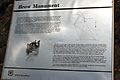
There are a number of National Forest Service signposts along the Brow Monument Trail.
-
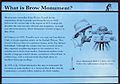
"What is Brow Monument?"
-
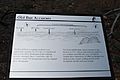
"Old but Accurate"
-
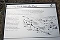
"Looking back into the past"
-
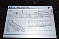
"Find them yourself"
-
"Brow Monument"


