Brownsville, Florida facts for kids
Quick facts for kids
Brownsville, Florida
|
|||
|---|---|---|---|
|
|||

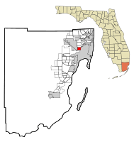
Location in Miami-Dade County and the state of Florida
|
|||

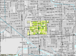
U.S. Census Bureau map showing CDP boundaries
|
|||
| Country | |||
| State | |||
| County | |||
| Area | |||
| • Total | 2.28 sq mi (5.90 km2) | ||
| • Land | 2.28 sq mi (5.90 km2) | ||
| • Water | 0.00 sq mi (0.00 km2) | ||
| Elevation | 10 ft (3 m) | ||
| Population
(2020)
|
|||
| • Total | 16,583 | ||
| • Density | 7,273/sq mi (2,810.7/km2) | ||
| Time zone | UTC-5 (Eastern (EST)) | ||
| • Summer (DST) | UTC-4 (EDT) | ||
| ZIP Code |
33142 (Miami)
|
||
| Area code(s) | 305, 786, 645 | ||
| FIPS code | 12-09000 | ||
| GNIS feature ID | 1867121 | ||
Brownsville (also called Brown Sub) is a community in South Florida. It is part of the larger Miami metropolitan area. Brownsville is a "census-designated place" (CDP). This means it's an area the government tracks for population, but it's not an official city. In 2020, about 16,583 people lived there. This was a rise in population after many years of decline.
Contents
History of Brownsville
Brownsville started as a settlement for white families in the 1920s. Later, between the late 1940s and early 1960s, many Black families moved into the area. This happened as the nearby Liberty Square community grew. Also, many white families moved to new suburban areas around Miami after World War II.
In 1945, a group called the Ku Klux Klan showed their opposition to Black home ownership. They burned crosses on lawns in the area.
By the mid-1960s, Brownsville was a busy and successful community for Black professionals. However, after the Civil Rights Act of 1968 was passed, things changed. This law made it illegal to prevent people from buying homes based on their race. Riots in 1968 and 1980 caused many middle and upper-class Black families to move away. This movement is sometimes called "black flight."
Brownsville's population kept shrinking from 1970 until 2000. This was part of a larger trend where many middle-class families moved to suburbs across the U.S. But between 2000 and 2010, Brownsville's population grew again. It reached 15,313 residents.
New Developments
In 2010, construction began on a big project called "Brownsville Transit Village." This project was built on 5.8 acres of land where the Brownsville Metrorail station parking lot used to be. The project cost $100 million. It includes 467 homes in five tall residential buildings. There are also shops on the ground floor. Everything is built around the Brownsville Metro station.
This project received some funding from the American Recovery and Reinvestment Act of 2009. It is one of the largest projects in Miami that combines public transportation with affordable housing.
Geography of Brownsville
Brownsville is located about 6 miles northwest of downtown Miami. It is bordered by the city of Miami to the east and southeast. To the north is Gladeview, and to the west is the city of Hialeah. Unincorporated Miami-Dade County is to the south. Interstate 195 (Airport Expressway) forms the southern edge of the community.
The Brownsville CDP covers a total area of 2.3 square miles. All of this area is land.
Population and Demographics
| Historical population | |||
|---|---|---|---|
| Census | Pop. | %± | |
| 1970 | 23,442 | — | |
| 1980 | 18,058 | −23.0% | |
| 1990 | 15,607 | −13.6% | |
| 2000 | 14,393 | −7.8% | |
| 2010 | 15,313 | 6.4% | |
| 2020 | 16,583 | 8.3% | |
| U.S. Decennial Census | |||
2020 Census Information
The table below shows the different racial and ethnic groups living in Brownsville. The U.S. Census counts Hispanic/Latino as an ethnic group, separate from racial categories. People of any race can be Hispanic/Latino.
| Race / Ethnicity (NH = Non-Hispanic) | Pop 2010 | Pop 2020 | % 2010 | % 2020 |
|---|---|---|---|---|
| White (NH) | 181 | 362 | 1.18% | 2.18% |
| Black or African American (NH) | 11,081 | 8,448 | 72.36% | 50.94% |
| Native American or Alaska Native (NH) | 13 | 15 | 0.08% | 0.09% |
| Asian (NH) | 7 | 16 | 0.05% | 0.10% |
| Pacific Islander or Native Hawaiian (NH) | 0 | 2 | 0.00% | 0.01% |
| Some other race (NH) | 10 | 45 | 0.07% | 0.27% |
| Mixed race or Multiracial (NH) | 82 | 154 | 0.54% | 0.93% |
| Hispanic or Latino (any race) | 3,939 | 7,541 | 25.72% | 45.47% |
| Total | 15,313 | 16,583 | 100.00% | 100.00% |
In 2020, there were 16,583 people living in Brownsville. These people lived in 6,070 households, and 3,521 of these were families. In 2010, there were 15,313 people, 4,476 households, and 2,744 families.
Local Sights
Brownsville is home to Georgette's Tea Room House. This tea room is owned by the Seventh-day Adventist Church.
Education
Miami-Dade County Public Schools manages the public schools in the Brownsville area.
Elementary Schools
- Lorah Park Elementary School
- Kelsey L. Pharr Elementary School
- Olinda Elementary School
- Earlington Heights Elementary School
- Charles Drew Elementary School
Middle Schools
- Brownsville Middle School
- Charles Drew Middle School
- Miami Springs Middle School
- Georgia Jones-Ayers Middle School
High Schools
- Miami Northwestern Senior High School
- Miami Jackson Senior High School
- Miami Springs Senior High School
Libraries
The Miami-Dade Public Library system runs the public libraries in the area.
- Model City Library
Transportation
Brownsville has public transportation options managed by Miami-Dade Transit. You can get around using Metrobus on major roads. There are also train services like the Miami Metrorail, Tri-Rail, and Amtrak.
Metrorail Stations
- Brownsville (located at North 54th Street and West 27th Avenue)
- Dr. Martin Luther King Jr. Plaza (located at North 62nd Street and West 27th Avenue)
Tri-Rail Stations
- Tri-Rail/Metrorail Transfer (located at North 79th Street and West 37th Avenue)
- Hialeah Market (located at North 41st Street and NW 38th Avenue)
Amtrak Station
- Amtrak-Miami: This station offers Silver Star and Silver Meteor train services. It is located at North 79th Street and West 37th Avenue.
See also
 In Spanish: Brownsville (Florida) para niños
 | Sharif Bey |
 | Hale Woodruff |
 | Richmond Barthé |
 | Purvis Young |


