
Buckland River (Victoria) facts for kids
Quick facts for kids Buckland |
|
|---|---|

The Buckland River at Beveridges Station, in the Mount Buffalo National Park
|
|

|
|
| Other name(s) | East Buckland, West Buckland |
| Country | Australia |
| State | Victoria |
| Region | Victorian Alps (IBRA), Victorian Alps |
| Local government area | Alpine Shire |
| Town | Porepunkah |
| Physical characteristics | |
| Main source | Buffalo Range, Victorian Alps |
| River mouth | confluence with the Ovens River Porepunkah 274 m (899 ft) 36°41′28″S 146°53′55″E / 36.69111°S 146.89861°E |
| Length | 39 km (24 mi) |
| Basin features | |
| River system | North-East Murray catchment, Murray-Darling basin |
| Basin size | 322 km2 (124 sq mi) |
| Tributaries |
|
| National parks | Alpine National Park; Mount Buffalo National Park |
The Buckland River is a river in Victoria, Australia. It's a "perennial river," meaning it flows all year round. It's part of the larger Murray-Darling Basin, which is a huge river system in Australia. The Buckland River starts in the Australian Alps and flows into the Ovens River near a town called Porepunkah.
Contents
Where is the Buckland River?
The Buckland River starts high up in the Barry Mountains. It begins from two smaller streams, the east and west branches. These streams meet below Mount Selwyn and The Twins. This meeting point is over 1,000 metres (3,300 ft) above sea level.
The river then flows mostly north. A lot of its journey is through the beautiful Mount Buffalo National Park. Eight smaller streams join the Buckland River along the way. Finally, it meets the Ovens River near the small town of Porepunkah. The river drops about 282 metres (925 ft) over its 39-kilometre (24 mi) length.
River Area and Surroundings
The area that collects water for the Buckland River is about 322 square kilometres (124 sq mi). This area is roughly 13 kilometres (8.1 mi) wide and 31 kilometres (19 mi) long. It stretches mainly from north to south. The entire area is within the Alpine Shire. This shire is a local government area in Victoria.
Flooding in the Buckland River
The Buckland River often experiences floods. The Bureau of Meteorology has special tools to check the river's height. These are located at Upper Buckland and Harris Lane. The amount of rain in the area can be very high. It can range from 1,100–1,640 millimetres (43–65 in) per year. This is because of the mountains and hills.
During winter, high areas above 1,500 metres (4,900 ft) get snow. Snow usually stays from June until September. In 2003, after big bushfires, a sudden flood happened. This flood caused many fish to die in the Ovens River. It also put town and farm water supplies at risk.
The River's Landscape
The Buckland River area is on the northern side of the Great Divide. Its height ranges from 350 metres (1,150 ft) to 1,703 metres (5,587 ft) at The Twins. Most of the land is very steep. It forms the foothills of the Victorian Alps. The hillsides are quite similar in shape. Along the river, there are rolling hills and narrow flat areas. These flat areas are found in the lower parts of the river.
What is the Buckland River's Geology?
Most of the river's area has layers of sandstone. These layers are up to one metre thick. They are mixed with dark grey shale and siltstone. These rocks formed a very long time ago. This was during the Middle to Upper Ordovician period.
There are also some areas with different types of rock. Near Paddys Hill, there is granite from the Devonian age. At Mount Selwyn, there is more granite from the Silurian age. Along the middle of the Buckland River, you can find deposits of clay, silt, sand, and gravel. These were left by ancient rivers during the Pleistocene age. Newer deposits of similar materials are found along the river channel. These extend about 2.5 km upstream from the Buckland Bridge.
The Gold Rush History

During the Victorian gold rush in the 1850s, many Chinese miners lived in the Buckland Valley. On July 4, 1857, a sad event happened. About 100 European miners forced most Chinese miners to leave the area. This event is known as the Buckland Riot.
The Buckland River had a lot of "alluvial gold." This means gold found in riverbeds. People used dredges to dig for gold in the 1800s. Smaller streams that flowed into the Buckland River also had a lot of gold.
In April 1897, new machinery was brought to Fairleys Creek. Investors from London put in £30,000 to help. This machinery had 30 "heads" for crushing rock. It was the biggest setup in the Upper Ovens goldfields. In November 1898, reports said that crushing was continuous. The gold found was not a lot per rock, but it was still making good money.
Famous People from the Buckland Valley
Alice Manfield was born in the Buckland Valley in 1878. She was known as Guide Alice. She became very important in the early days of white settlement at Mount Buffalo. She also helped to create the Mount Buffalo National Park.
Images for kids
-
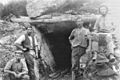
Miners at Fairleys Creek, Buckland Valley.
