Budgam district facts for kids
Quick facts for kids
Budgam
Badgom
Badgam
|
|
|---|---|
|
District of Jammu and Kashmir administered by India
|
|

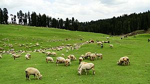
Doodhpathri pastures in Budgam district
|
|
| Nickname(s):
Jackals Cave
|
|

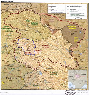
Budgam district is in Indian-administered Jammu and Kashmir in the disputed Kashmir region It is in the Kashmir division (bordered in neon blue).
|
|
| Administering country | India |
| Union Territory | Jammu and Kashmir |
| Division | Kashmir |
| Established | 1979 |
| Founded by | Aga Syed Yousuf |
| Named for | Large Village |
| Headquarters | Budgam |
| Tehsils | |
| Government | |
| • Type | District Development Council of Budgam |
| • Body | District Development Council |
| Area | |
| • Total | 1,370 km2 (530 sq mi) |
| Population
(2011)
|
|
| • Total | 753,745 |
| • Density | 537/km2 (1,390/sq mi) |
| Demonym(s) | Badgaime |
| Languages | |
| • Official | Kashmiri, Urdu, Hindi, Dogri, English |
| Time zone | UTC+5:30 (IST) |
| Vehicle registration | JK04 |
| Sex ratio | 1.13250283 ♂/♀ |
| Literacy | 57.98% |
| Villages | Ichgam, Khan Sahib, Jammu and Kashmir, Dooniwari, Beerwah, Gariend KhurdKandooraKandoora Chadoora, Parnewa, Wahabpora, wadwan bandgam (famous for its karewa, naarwuder bajmarg haren nandwuder it is a "valley inside the valley" |
Budgam district is an important administrative area in Jammu and Kashmir, India. It was created in 1979. The main town and headquarters of the district is also called Budgam. This district is known for having a large population of Shia Muslims in the Kashmir valley.
Contents
Administration
Budgam district is very close to Srinagar, the capital city of the union territory, only about 11 kilometers away. Before 1979, Budgam was actually part of Srinagar district. Even earlier, it was part of Baramulla district. Historically, it was sometimes called Pargana Deesu or Deedmarbag.
Budgam district shares its borders with other districts. To the north, it borders Baramulla and Srinagar. To the south, it borders Pulwama, and to the southwest, it borders Poonch.
The district is divided into seventeen administrative blocks. These blocks include Beerwah, Budgam, B.K.Pora, Chadoora, Charari Sharief, Khag, Khansahib, Nagam, Narbal, Pakherpora, Parnewa, Rathsoon, Soibugh, Sukhnag, Surasyar, S.K.Pora, and Waterhail. Each block is further divided into smaller local councils called panchayats.
The district also has nine main subdivisions called tehsils. These are Charari Sharief Tehsil, Magam Tehsil, Beerwah Tehsil, Budgam Tehsil, Chadoora Tehsil, Khansahib Tehsil, Khag Tehsil, BK Pora Tehsil, and Narbal Tehsil.
Quick Facts
| Number of Sub-divisions | 3 |
| Number of Municipalities | 6 |
| Number of Tehsils | 9 |
| Number of Blocks | 17 |
| Number of Gram Panchayats | 281 |
| Number of Villages | 510 |
People and Languages
| Religion in Budgam district (2011) | ||||
|---|---|---|---|---|
| Religion | Percent | |||
| Islam | 97.65% | |||
| Hinduism | 1.34% | |||
| Sikhism | 0.74% | |||
| Other or not stated | 0.27% | |||
According to the 2011 census, Budgam district has a population of about 735,753 people. This makes it the 494th most populated district in India. The district has about 554 people living per square kilometer.
The population grew by about 24.14% between 2001 and 2011. For every 1000 males, there are 883 females in Budgam. The literacy rate, which is the percentage of people who can read and write, is 56.08%. This means more than half the population is literate. Literacy is higher in cities (about 68.87%) compared to rural areas (about 54.01%).
| Sex Ratio in Badgam District in 2011 Census. (no. females per 1,000 males) |
||||
|---|---|---|---|---|
| Religion (and population) | Sex Ratio | |||
| Muslim (pop 736,054) | 915 | |||
| Hindu (pop 10,110) | 109 | |||
| Sikh (pop 5,559) | 674 | |||
| Other (pop 2,022) | 532 | |||
| Total (pop 753,745) | 894 | |||
Most people in Budgam district speak Kashmiri as their first language (about 94.78%). About 3.01% of the population speaks Gojri.
Education
Budgam district has many schools, both private and public. There are 590 schools in total, and 33 of them are Higher Secondary Schools. This means students can complete their high school education there.
There are also six Government Degree Colleges where students can pursue higher education:
- Government Degree College Beerwah
- Government Degree College Khansahib
- Government Degree College Magam
- Sheikh ul Aalam Memorial Degree College Budgam
- Model Degree College Chrar e Sharif
- Government Degree College Chadoora
Railways
Budgam district has three railway stations that are part of the Jammu–Baramulla line. These stations are Budgam, Nadigam, and Mazhom.
Budgam railway station is located in Ompora town. It's about 2.5 kilometers from Budgam's main district office and 9 kilometers from Srinagar's city center. This is the largest railway station in the Kashmir valley. It also serves as the main office for controlling train services in the area.
Health Care
While many people in Budgam rely on hospitals in the capital city of Srinagar, the district also has its own health facilities. There is one main District Hospital in Budgam city. Additionally, there are Sub-District Hospitals in Beerwah, Khan Sahib, Magam, and Chadoora.
Near Budgam railway station, there is a large private hospital called Ibn-Sina Hospital. It is the first private hospital in Budgam district.
Tourist Attractions
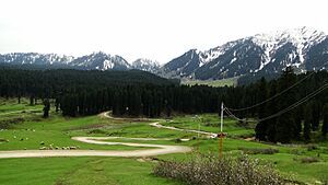
Budgam district is home to the only airport in the Kashmir valley, located in Ichgam. The district has many beautiful places that attract tourists. Some of the main attractions include Doodhpathri, Yusmarg, Tosamaidan, Nilnag, Khag, and Pehjan. These places offer stunning views and have a lot of potential for tourism.
One famous item from the region is the Kani Shawl. These special shawls were once worn in royal courts and were seen as a sign of importance by Mughal rulers. In 1776, Napoleon Bonaparte even gave a Kani shawl to his wife Josephine, which helped start a new fashion trend in Europe.
The respected shrine of Sheikh Noor-ud-din Wali is also located in the Charari Sharief Tehsil of Budgam district. Asia's oldest and largest Chinar tree can be found at Chattergam Budgam. The Aga Sahib Shrine and the Tomb of Shams-ud-Din Araqi are also important historical sites in this district.
Notable People
- Nund Rishi
- Shamas Faqir
- Ghulam Nabi Gowhar
- Samad Mir
- Aga Syed Yusuf Al-Moosavi Al-Safavi
- Mir Shams-ud-Din Araqi
- Aga Syed Mohammad Fazlullah
- Aga Mir Syed Mohammad Baqir Mosavi
- Aga Syed Mustafa Al-Moosavi
- Aga Syed Mehdi
- Aga Syed Mohsin
See also
 In Spanish: Distrito de Badgam para niños
- Kupwara district
- Ganderbal district
- Anantnag district
- Pulwama district
 | Georgia Louise Harris Brown |
 | Julian Abele |
 | Norma Merrick Sklarek |
 | William Sidney Pittman |


