
Bulls Tooth facts for kids
Quick facts for kids Bulls Tooth |
|
|---|---|

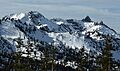
Bulls Tooth, east aspect
|
|
| Highest point | |
| Elevation | 6,840 ft (2,080 m) |
| Prominence | 1,280 ft (390 m) |
| Isolation | 3.29 mi (5.29 km) |
| Parent peak | Snowgrass Mountain (7,993 ft) |
| Geography | |

Bulls Tooth
Location in Washington (state)

Bulls Tooth
Location in the United States
|
|
| Location | Chelan County Washington state, U.S. |
| Parent range | Chiwaukum Mountains Wenatchee Mountains Cascade Range |
| Topo map | USGS Stevens Pass |
| Climbing | |
| Easiest route | Scrambling |
Bulls Tooth is a mountain in Washington state. It stands tall at 6,840+ ft (2,080+ m) (about 2,085 meters). You can find it in Chelan County.
This mountain is about 5.5 mi (8.9 km) southeast of Stevens Pass. It is located within the beautiful Alpine Lakes Wilderness. The land around it is managed by the Okanogan-Wenatchee National Forest.
Bulls Tooth is part of the Chiwaukum Mountains. These mountains are a smaller part of the larger Cascade Range. Its closest taller neighbor is Snowgrass Mountain, about 3.3 mi (5.3 km) to the east.
Rain and snow melting from Bulls Tooth flow into Icicle Creek. This creek then joins the Wenatchee River. A person named Albert Hale Sylvester gave it the name 'Bulls Tooth'. He thought it looked a bit like a tooth!
Weather at Bulls Tooth
Most weather systems start over the Pacific Ocean. They then travel east towards the Cascade Range. When these weather systems hit the tall Cascade Mountains, they are forced to rise.
As the air rises, it cools down and drops its moisture. This causes a lot of rain or snow to fall on the mountains. This effect is called Orographic lift. Because of this, the Cascades get a lot of precipitation. This is especially true during the winter months, when there is often heavy snowfall.
In winter, the weather is usually cloudy. But during the summer, high-pressure systems form over the Pacific Ocean. These systems often bring clear skies and sunshine to the mountains.
How Bulls Tooth Was Formed
The Alpine Lakes Wilderness area has very rugged land. You can see jagged peaks, sharp ridges, and deep valleys carved by glaciers. There are also granite rock walls and over 700 mountain lakes.
Many years ago, big geological events shaped this area. These events created the varied landscape and huge changes in elevation. This also led to the different climates across the Cascade Range. For example, Glacier Peak is a stratovolcano. It is about 30 mi (48 km) north of Bulls Tooth. It started forming millions of years ago.
During the Pleistocene period, which was over two million years ago, glaciers moved across the land many times. These huge ice sheets scraped and shaped the landscape. They left behind piles of rock and debris. The last time glaciers retreated from the Alpine Lakes area was about 14,000 years ago. By 10,000 years ago, they had moved north of the Canada–US border.
The river valleys in this area have a "U" shape. This shape was created by the recent glaciers. The mountains were also pushed up by forces inside the Earth (orogeny). Cracks in the Earth's crust (faulting) also played a role. These processes, along with glaciation, created the tall peaks and deep valleys we see today in the Alpine Lakes Wilderness.
Images for kids
-
Bulls Tooth, east aspect
