Bungaroo facts for kids
Quick facts for kids BungarooNew South Wales |
|
|---|---|

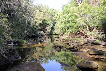
Bungaroo (looking upstream)
|
|
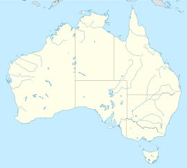
Bungaroo is a place near St. Ives in Sydney, Australia. Many people believe this is where Governor Arthur Phillip and his group camped on April 16, 1788. They were on an important trip to find good land for farming. The new colony at Sydney Cove needed food, but the soil around the harbour was not good enough for crops.
This trip was a big deal for the Ku-ring-gai area, as it was the first time Europeans explored there. It was also historic for the whole colony because it was when the Blue Mountains were first seen. Governor Phillip thought that such large mountains must mean there was a big river nearby with rich soil. This meant the colony could survive by growing its own food. Soon after, the Governor focused on exploring westwards, which changed a lot of things. Some people today think Bungaroo is the only place from 1788 that still looks the same.
Contents
History of Bungaroo: Early Explorations and Changes
On April 15, 1788, Captain Phillip and his group landed at Manly. They named the spot and then headed west. They reached Middle Harbour near where the Roseville Bridge is today. The group then traveled up the waterway until the tide stopped. They camped by a freshwater pool that night. One person in the group described the area as "the most desert wild and solitary seclusion the imagination can form any idea of."
How Bungaroo Became a Popular Spot
In 1885, the area was surveyed and divided into smaller pieces. This was part of the St. Ives development. The creek valley stayed wild, but the tidal limit was marked. A surveyor's line later became a walking path. In the 1920s, there was a plan to build a railway line along the creek valley. But local people and councillors protested, and the plan was stopped.
By the 1930s, the area was well-known for picnics, bushwalking, and its natural beauty. There was a popular swimming spot called The Cascades. This pool was built by workers who were unemployed during the Great Depression. Older people still remember going to The Cascades pool. They called it "going to Bungaroo."
The Name "Bungaroo"
Mentions of "Bungaroo" meaning The Cascades pool appear in Gal Halstead's 1982 book, "The Story of St. Ives." She collected many family stories from people living in St. Ives. It's not clear why the name "Bungaroo" is now shown on maps in a different spot. One idea is that "Bungaroo" might have originally been the name for the whole creek (Middle Harbour Creek), not just one specific place along it.
The book shows that the name was used as early as 1909 to mean what is now called The Cascades pools. This was a favorite place for children in early St. Ives. Stories from the book include:
- "Snow" Bedwin remembered workers building the road to it during the Depression in the 1920s.
- "Ali" Bartho caught a very large Death adder there, which was given to the Australian Museum.
- A Scout Jamboree was held there. Scouts on a nearby hill sent a flaming torch down a wire to light a huge bonfire.
- Troops stationed at St. Ives Showground during World War II used the area.
- The swimming pool there later became polluted. The local council had to blow up the barrier.
The book suggests "Bungaroo" means 'Resting place'. Other ideas for its meaning include an Aboriginal name for the Salt Water Turtle or 'running water'.
Exploring the Bungaroo Area Today
The Bungaroo area is part of Garigal National Park. It is looked after by the New South Wales National Parks and Wildlife Service and the Ku-ring-gai Council. The area still has its native plants, like Banksias, Grevilleas, and wildflowers in spring. There are also many rocky areas. These include the large sandstone steps known as the 'Stepping Stones'. These stones separate the salty water of Middle Harbour from the fresh water of Middle Harbour Creek.
Walking tracks follow the creek valley. You can walk between the top of Middle Harbour and the northern parts of Garigal National Park. Other tracks connect the Stepping Stones crossing with St Ives to the west and the Davidson Trail in Frenchs Forest to the east.
How to Visit Bungaroo
There are a few ways to get to the Bungaroo area:
- Founders Way Walking Track: This track starts from Hunter Ave in St Ives. It leads to the Pipeline Track (a 4WD maintenance trail) and the Bungaroo Track (a narrow walking trail). Both tracks go down to Middle Harbour Creek. They are in good condition and are popular for local walkers.
- Middle Harbour Track: This track starts from The Cascades in Garigal National Park. It leads to the Governor Phillip Walk. The track follows the eastern side of Middle Harbour towards Forestville, New South Wales.
 | Madam C. J. Walker |
 | Janet Emerson Bashen |
 | Annie Turnbo Malone |
 | Maggie L. Walker |


