
Middle Harbour Creek facts for kids
Quick facts for kids Middle Harbour Creek |
|
|---|---|

Middle Harbour Creek after heavy storms downstream from the cascades
|
|
| Country | Australia |
| State | New South Wales |
| Region | Sydney basin (IBRA), Northern Beaches |
| Local government areas | Warringah |
| Physical characteristics | |
| River mouth | Middle Harbour Castlecrag and Seaforth 33°47′40.38″S 151°13′57.18″E / 33.7945500°S 151.2325500°E |
| Length | 6.1 km (3.8 mi) |
| Basin features | |
| River system | Middle Harbour |
| Basin size | 77 km2 (30 sq mi) |
| Tributaries |
|
| National park | Garigal National Park |
Middle Harbour Creek is a stream in Sydney, New South Wales, Australia. It flows into Middle Harbour, which is part of Sydney Harbour. This creek is a special type of waterway called an estuary, where fresh water from the land mixes with salty ocean water.
Contents
About Middle Harbour Creek
Middle Harbour Creek starts where two smaller streams, Bare Creek and Frenchs Creek, join together. This meeting point is north of a suburb called Davidson. The creek then flows through the beautiful Garigal National Park.
The creek eventually reaches a place called Bungaroo, where it widens and becomes Middle Harbour. The entire area that collects water for the creek, known as its catchment area, is about 77 square kilometres (30 sq mi).
Exploring the Creek
It's easy to visit Middle Harbour Creek! There are many walking tracks along both its western and eastern sides. You can find access points from suburbs like St Ives, East Killara, and East Lindfield on the western side. On the eastern side, you can access it from Belrose, Davidson, Frenchs Forest, and Forestville.
Many people enjoy day walks along the creek. Some of the most popular tracks are:
- The Bungaroo Track
- The Cascades Track
- The Bare Creek Track
The bushland around the creek is full of interesting trees. You might see Bloodwoods (Eucalyptus gummifera), Scribbly Gums (Eucalyptus haemastoma), and Narrow-leaved Stringybarks (Eucalyptus oblonga).
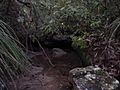
The Cascades Track
The Cascades Track is a well-known path that leads to a beautiful spot called the Cascades. Here, water flows wonderfully over sandstone rocks. You can start this track from Acron Road and Douglas Street in St Ives, or from Stone Parade in Frenchs Forest.
The track is a well-kept fire trail, but it has a very steep section. You'll also need to cross the creek at a ford (a shallow place where you can walk across). Until the 1970s, the Cascades was a popular swimming spot for local children. There are also some sandstone caves nearby that offer great views of the area.
The Bare Creek Track
The Bare Creek Track is another path you can explore. It starts near the intersection of Mona Vale Road and Forest Way Roads. However, this part of the trail can be hard to find because it's often overgrown.
A better way to find the Bare Creek Track is to follow the trail from the end of Wyatt Avenue. This path goes behind the Sydney East Substation and connects to the Heath Track. After a short walk on the Heath Track, you will reach the Bare Creek Track.
History of the Creek
Middle Harbour Creek was first explored by Governor Arthur Phillip. He led an expedition that started from Manly Cove on April 15, 1788. The main goal of this trip was to find new sources of food. On April 16, 1788, the expedition camped at Bungaroo. This is the place where the tidal part of Middle Harbour ends and Middle Harbour Creek begins.
Gallery
-
Middle Harbour Creek close to its source near Mona Vale Road St Ives.

- The Northern Beaches Mountain Biking Group (NoBMoB) has details of trails around Cascades.
