Buttermilk Creek (Susquehanna River tributary) facts for kids
Quick facts for kids Buttermilk Creek |
|
|---|---|

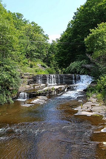
Buttermilk Creek looking upstream at Buttermilk Falls
|
|
| Physical characteristics | |
| Main source | Fords Lake in Newton Township, Lackawanna County, Pennsylvania between 1,140 and 1,160 feet (347 and 354 m) |
| River mouth | Susquehanna River in Falls Township, Wyoming County, Pennsylvania 564 ft (172 m) 41°27′37″N 75°51′02″W / 41.4602°N 75.8506°W |
| Length | 6.8 mi (10.9 km) |
| Basin features | |
| Progression | Susquehanna River → Chesapeake Bay |
| Basin size | 26.1 sq mi (68 km2) |
| Tributaries |
|
Buttermilk Creek is a stream, also called a tributary, in Pennsylvania, United States. It flows into the Susquehanna River. The creek is about 6.8 miles (11 kilometers) long. It runs through Lackawanna County and Wyoming County.
The area of land that drains into the creek, called its watershed, is about 26.1 square miles (67.6 square kilometers). Buttermilk Creek flows all year round. It is considered a healthy waterway. Important places in its watershed include Buttermilk Falls, Fords Lake, and Lake Winola.
Many bridges have been built over Buttermilk Creek. There are also some towns and buildings in the watershed. In the early 1900s, farming and summer resorts were common here. The creek's watershed is a good place for coldwater fish. It is also important for fish that travel to lay eggs.
Contents
Where Buttermilk Creek Flows
Buttermilk Creek starts at Fords Lake in Newton Township, Lackawanna County. It flows south for a short distance. Then it turns west for several miles. As it flows, the creek enters a valley. It passes two small lakes or ponds. It also flows by Griffin Hill.
The creek then enters Falls Township in Wyoming County. Here, it turns northwest for a short distance. It crosses Pennsylvania Route 307. The creek then slowly turns west and southwest. It stays in its valley and flows next to Pennsylvania Route 307.
Buttermilk Creek then meets Beaver Creek, its first named side stream, from the right. It turns south. After a short distance, it turns west. It then meets Falls Creek, another side stream, from the left. The creek then turns south-southwest for more than a mile. Its valley gets wider.
It then turns south-southeast for a short distance. After that, it turns south-southwest again. At this point, the creek turns west. After a short distance, it flows past Buttermilk Falls. Finally, it joins the Susquehanna River.
Buttermilk Creek joins the Susquehanna River about 208.58 miles (335.68 kilometers) upstream from the Susquehanna's mouth.
Buttermilk Creek's Side Streams
Buttermilk Creek has two named side streams, also called tributaries. They are Falls Creek and Beaver Creek.
- Falls Creek joins Buttermilk Creek about 2.00 miles (3.22 kilometers) upstream from its mouth. The area that drains into Falls Creek is about 7.27 square miles (18.8 square kilometers).
- Beaver Creek joins Buttermilk Creek about 2.58 miles (4.15 kilometers) upstream from its mouth. The area that drains into Beaver Creek is about 9.81 square miles (25.4 square kilometers).
Water and Weather Around Buttermilk Creek
Buttermilk Creek is not listed as an "impaired waterbody." This means its water quality is good. It is one of only two streams in its area that flow all year long.
In the early 1900s, the Buttermilk Creek area received about 35 to 40 inches (89 to 102 centimeters) of rain each year.
Land and Rocks Around Buttermilk Creek
The land near where Buttermilk Creek joins the Susquehanna River is about 564 feet (172 meters) above sea level. Where the creek starts, its elevation is between 1140 and 1160 feet (347 and 354 meters) above sea level.
In 1921, a report described the land around Buttermilk Creek as "rough and hilly." The creek's valley is surrounded by steep hills. These hills were made round by glaciers long ago. The creek's path is curvy. It flows through sandstone rock formations.
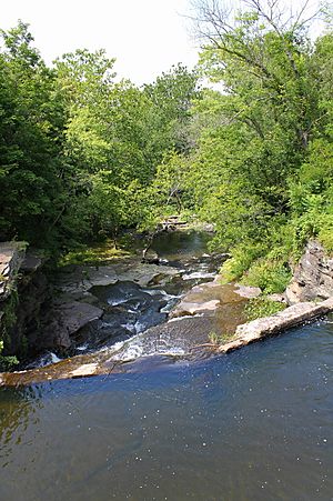
Long ago, piles of glacial drift (rocks and dirt left by glaciers) changed Buttermilk Creek's path. This made the creek flow over cliffs, creating a waterfall. The cliffs are 155 feet (47 meters) tall. They are made of sandstone rock.
These waterfalls are known as Buttermilk Falls. They are a series of smaller waterfalls. Each one is 10 to 35 feet (3.0 to 10.7 meters) tall. They are considered an excellent example of this type of waterfall system in Pennsylvania. The falls are located about 0.3 miles (0.48 kilometers) upstream from the creek's mouth.
Buttermilk Creek flows through a narrow passage in its lower parts. In some areas, the creek flows through flat, low-lying lands and swamps. These areas are also made of glacial drift.
Above Buttermilk Falls, Buttermilk Creek flows over glacial drift. The creek is a relatively small stream. Its source is in a mountain lake.
The surface of the land along most of Buttermilk Creek is covered by alluvium. This is soil and sediment deposited by flowing water. In the creek's upper parts, the surface is covered by a type of glacial deposit called Wisconsinan Till.
In the middle and lower parts, there are also small areas of Wisconsinan Outwash. This contains layers of sand and gravel. There is also Wisconsinan Ice-Contact Stratified Drift. This has layers of sand and gravel, and some large rocks called boulders. Solid bedrock is also found near the creek's mouth.
Additionally, the watershed has some alluvial fans (fan-shaped deposits of sediment). It also has peat bogs and other wetlands. There are lakes and pits where sandstone and shale were dug up.
Buttermilk Creek's Watershed
The watershed of Buttermilk Creek covers about 26.1 square miles (67.6 square kilometers). The entire creek is within the Ransom area on a United States Geological Survey map. Most of its watershed is in southwestern Lackawanna County and southeastern Wyoming County.
A company called Geary Enterprises is allowed to take up to 99,000 gallons (370,000 liters) of water per day from Buttermilk Creek. This company uses the water for drilling gas wells.
There are several lakes in the Buttermilk Creek watershed. Important ones include Fords Lake, which is on Buttermilk Creek itself. Another is Lake Winola, which covers about 190 acres (77 hectares). Lake Winola is on one of Buttermilk Creek's side streams. In the 1970s, people suggested building a 140-acre (57-hectare) reservoir on the creek. This would have been about 0.25 miles (0.40 kilometers) upstream from its mouth. It could have provided many days of recreation each year.
History of Buttermilk Creek
Buttermilk Creek was officially added to the Geographic Names Information System on August 2, 1979. This system keeps track of place names in the United States.
In the mid-1800s, the Buttermilk Creek watershed was mostly wild. Not many people lived there. However, there was a small village where the creek met the river. This village had some flour mills and a factory. Today, the area near Buttermilk Falls is developed. A village called Falls is located at the creek's mouth.
In the early 1900s, the main jobs in the Buttermilk Creek watershed were agriculture (farming) and running a summer resort. Major towns in the watershed at that time included Mill City, Falls, and Lake Winola. Their populations were 415, 155, and 60 people, respectively.
Several bridges have been built over Buttermilk Creek over the years:
- A steel bridge for T362/Creek Flats Road was built in 1916 in Falls. It was repaired in 1982 and is 30.8 feet (9.4 meters) long.
- A concrete bridge for State Route 2027 was built in 1958 in Falls Township. It is 24.0 feet (7.3 meters) long.
- A wood bridge for T373 was built in 1978 in Falls Township. It is 32.2 feet (9.8 meters) long.
- A strong concrete bridge for State Route 2015 was built in 1990 in Falls Township. It is 60.0 feet (18.3 meters) long.
One bridge over the creek in Falls Township was damaged by floods in 2006. In 2007, a company called Quality Engineering Solutions began a project to fix that bridge. This project was paid for by the Federal Emergency Management Agency.
Animals and Plants Around Buttermilk Creek
The area that drains into Buttermilk Creek is special for fish. It is called a Coldwater Fishery. This means it's a good place for fish that like cold water. It's also a Migratory Fishery. This means it's important for fish that travel to lay their eggs.
Hemlock trees grow along the creek in its lower parts. Buttermilk Falls on Buttermilk Creek is listed as an important natural area in Wyoming County.
 | Bayard Rustin |
 | Jeannette Carter |
 | Jeremiah A. Brown |


