
Buttes of the Cross facts for kids
Quick facts for kids Buttes of the Cross |
|
|---|---|

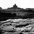
Buttes of the Cross, east aspect
|
|
| Highest point | |
| Elevation | 5,642 ft (1,720 m) |
| Prominence | 1,042 ft (318 m) |
| Isolation | 1.59 mi (2.56 km) |
| Parent peak | Point 5820 |
| Geography | |

Buttes of the Cross
Location in Utah

Buttes of the Cross
Location in the United States
|
|
| Location | Glen Canyon National Recreation Area Wayne County, Utah, US |
| Parent range | Colorado Plateau |
| Topo map | USGS Cleopatras Chair |
| Geology | |
| Age of rock | Late Triassic |
| Type of rock | Wingate Sandstone |
| Climbing | |
| Easiest route | class 5.x climbing |
The Buttes of the Cross are two tall rock formations located in Glen Canyon National Recreation Area in Utah, United States. These amazing sandstone peaks are found in Wayne County.
The taller peak, known as the south butte, stands at 5,642 feet (1,720 meters) high. The north butte is a bit shorter at 5,569 feet. The two peaks are about 0.6 miles (1 km) apart.
When you look at them from certain angles, especially from the north-northeast near Labyrinth Canyon, they line up perfectly. This makes them look like a single giant cross shape!
The famous explorer John Wesley Powell first named one of these peaks "Butte of the Cross" during his expedition in 1869. Later, as he traveled further down the Green River, he saw that it was actually two separate buttes. So, he renamed them "Buttes of the Cross." These buttes rise more than 1,400 feet (425 meters) above the land around them. They are located about 6.8 miles west of Candlestick Tower. They are also very close to Canyonlands National Park, just half a mile outside its border.
Contents
What Are Buttes of the Cross Made Of?
The Buttes of the Cross are made from a type of rock called Wingate Sandstone. This sandstone is very hard and fine-grained. It formed from ancient sand dunes that were blown by the wind about 200 million years ago. This was during a time period called the Late Triassic.
Imagine a huge desert where sand piled up over millions of years! Over time, this sand turned into solid rock. The Wingate Sandstone forms steep cliffs. It sits on top of softer rock layers. Rainwater from the buttes flows into the nearby Green River. This river is part of the larger Colorado River system.
Climbing the Buttes
Climbing these buttes is a challenging adventure!
- The North Butte was first climbed on May 25, 1987. The climbers were Paul Horton and Lynn Watson. They used a route called West Chimneys.
- The South Butte was first climbed in 1994. John Rosholt and Keen Butterworth made this first ascent. Their route was named The Epicurean and was on the north face of the butte. It is rated class 5.10c, which is a difficult climb.
Weather Around the Buttes
The best times to visit the Buttes of the Cross are in the spring and fall. The area has a Cold semi-arid climate. This means that the coldest month usually has an average temperature below 32°F (0°C). Also, at least half of the year's rain falls during spring and summer.
This desert climate doesn't get much rain, usually less than 10 inches (250 mm) each year. Snowfall in the winter is usually light.
Gallery
-
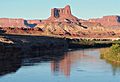
Buttes of the Cross from Green River
-
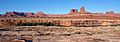
Buttes of the Cross, right of center
-
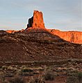
The north butte
-
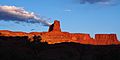
The north butte
-
Historical photo by John Karl Hillers from Powell's second expedition (1871-72)
-

From the southeast
-

-
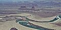
Aerial view from the east


