
California Historical Landmarks in El Dorado County facts for kids
El Dorado County in California is a super cool place with a rich history! It's famous for being a big part of the California Gold Rush, which changed the state forever. Many important spots here are marked as California Historical Landmarks. These landmarks help us remember the exciting events and people who lived here long ago.
This article will take you on a journey through some of El Dorado County's most famous historical places. You'll learn about where gold was first found, important roads, and even stops along the famous Pony Express route. Get ready to explore the past!
Contents
Discovering Gold in El Dorado County
El Dorado County is where the California Gold Rush officially began. Imagine a time when people rushed to California hoping to strike it rich!
The Gold Discovery Site
One of the most famous spots is the Gold Discovery Site in Coloma. This is where James W. Marshall found gold at Sutter's Mill on January 24, 1848. This discovery kicked off the massive Gold Rush. Thousands of people from all over the world came to California looking for gold. It changed California from a quiet place into a bustling center of activity.
Marshall Monument
Also in Coloma, you'll find the Marshall Monument. This monument honors James W. Marshall, the man who first discovered gold. It's located in the Marshall Gold Discovery State Historic Park. This park helps preserve the history of the Gold Rush and shows what life was like back then.
Marshall's Blacksmith Shop
Near Kelsey, there's a historical marker for Marshall's Blacksmith Shop. This was the workshop of James W. Marshall. Blacksmiths were very important in those days, making and repairing tools for miners and settlers.
Roads and Routes of the Past
Before cars, people traveled by foot, horse, or wagon. Old roads and trails are important historical landmarks.
Coloma Road
The Coloma Road was a vital path during the Gold Rush. It connected the gold fields to other parts of California. There are two main sections marked as historical landmarks:
- Coloma Road-Coloma: This part is located within the Marshall Gold Discovery State Historic Park. It shows how people traveled to the gold discovery site.
- Coloma Road-Rescue: This section is near the Rescue Junction General Store in Rescue. It reminds us of the long journeys people made.
The Pony Express Route
The Pony Express was a super-fast mail service that used horseback riders. It operated for only about 18 months (1860-1861). But it was a thrilling way to send letters across the country! Several spots in El Dorado County were important stops along this route.
El Dorado-Nevada House (Mud Springs)
In El Dorado, you can find the site of the El Dorado-Nevada House, also known as Mud Springs. This was an important stop for Pony Express riders to rest and change horses.
Friday's Station
Near the state line on Highway 50, Friday's Station was another key Pony Express stop. Riders would push themselves and their horses to the limit to deliver mail quickly.
Moore's (Riverton)
Near Kyburz, the site of Moore's (Riverton) was a Pony Express station. These stations were crucial for the riders to keep going on their long and dangerous journeys.

Placerville Pony Express Stop
The city of Placerville was also a significant stop on the Pony Express route. It was a busy town during the Gold Rush, and the Pony Express brought important news and letters.
Pleasant Grove House
In Rescue, the Pleasant Grove House was another stop for Pony Express riders. These houses offered food, shelter, and fresh horses.
Sportsman's Hall
Near Cedar Grove, Sportsman's Hall was a well-known Pony Express station. It was a place where riders could take a break before continuing their journey through the mountains.
Strawberry Valley House
In Strawberry, the Strawberry Valley House was a high-altitude Pony Express stop. The route through the Sierra Nevada mountains was very challenging.
Yank's Station
Near Meyers, Yank's Station was the last Pony Express stop in El Dorado County before riders headed into Nevada. It was a vital link in the chain.
Site of Echo Summit
Echo Summit was a challenging part of the Pony Express route. It's a high mountain pass that riders had to cross, often facing harsh weather.
Historic Towns and Communities
Many towns in El Dorado County have deep historical roots, especially from the Gold Rush era.
Diamond Springs
Diamond Springs was a bustling town during the Gold Rush. It was named for the sparkling spring waters found there. It played a role in the early days of mining.
El Dorado
The town of El Dorado was another important settlement during the Gold Rush. Its name means "the golden one" in Spanish, showing its connection to the gold discoveries.
Georgetown
Georgetown was founded in 1849 and was a lively mining town. It's known for its unique street layout, which was designed to make it harder for fires to spread.
Greenwood
Greenwood was an early mining camp that grew into a town. It was named after a local store owner. Many miners passed through or settled here.
Placerville
Placerville is one of the most famous Gold Rush towns. It was originally known by a different, darker name, but later became Placerville. It was a major center for mining and trade.
Hangman's Tree
In Placerville, the site of the Hangman's Tree is a historical landmark. It reminds us of the rough justice that sometimes happened during the Gold Rush.
Methodist Episcopal Church
The Methodist Episcopal Church in Placerville is a historic building. Churches were important community centers in early California towns.
Old Dry Higgins-Old Hangtown
This landmark in Placerville refers to the early days of the town, when it was known as "Hangtown." It marks a significant historical area.
Studebaker's Shop
In Placerville, the site of Studebaker's Shop is marked. This was where John Studebaker, who later became famous for making cars, started his career building wagons for miners.
Shingle Springs
Shingle Springs was named for the shingle-making industry that developed there. It was a supply point for miners and travelers.
Mormon Island
Mormon Island was one of the earliest gold mining camps in California. It was settled by members of the Mormon Battalion in 1848. It's now submerged under Folsom Lake.
Negro Hill
Negro Hill was another important mining camp in the Gold Rush. It was known for its rich gold deposits. Like Mormon Island, it is now part of the Folsom Lake State Recreation Area.
Salmon Falls
Salmon Falls was a thriving mining town on the American River. It was a busy place during the Gold Rush, but it was later flooded when Folsom Lake was created.
Condemned Bar
Condemned Bar was a mining site along the American River. It was known for its gold deposits, but also for being a challenging place to mine. It's now part of Folsom Lake State Recreation Area.
Other Significant Landmarks
El Dorado County has other unique historical sites.
Site of California's First Grange Hall
Near Pilot Hill, you can find the site of California's First Grange Hall. The Grange is an organization that supports farmers and rural communities. This site marks an important step in California's agricultural history.
Mountain Quarries Railroad Bridge
The Mountain Quarries Railroad Bridge is a historic bridge near Auburn. It was built for a railroad that carried materials from quarries. It's an impressive example of early 20th-century engineering.

Wakamatsu Tea and Silk Farm Colony
The Wakamatsu Tea and Silk Farm Colony near Gold Hill is a very special place. It was the first Japanese colony in America, established in 1869. The colonists tried to grow tea and silk, bringing Japanese culture and farming methods to California.
Images for kids
-
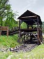
A replica of Sutter's Mill, where gold was first discovered.
-
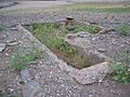
Foundations of buildings at Salmon Falls, now part of Folsom Lake.


