Callahan County, Texas facts for kids
Quick facts for kids
Callahan County
|
|
|---|---|

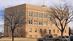
Callahan County Courthouse in Baird
|
|

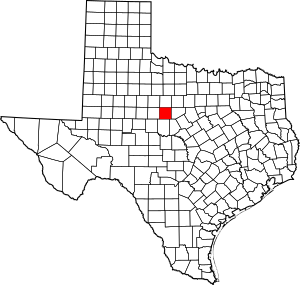
Location within the U.S. state of Texas
|
|
 Texas's location within the U.S. |
|
| Country | |
| State | |
| Founded | 1877 |
| Seat | Baird |
| Largest city | Clyde |
| Area | |
| • Total | 901.3 sq mi (2,334 km2) |
| • Land | 899.4 sq mi (2,329 km2) |
| • Water | 1.9 sq mi (5 km2) 0.2% |
| Population
(2020)
|
|
| • Total | 13,708 |
| • Estimate
(2021)
|
14,115 |
| • Density | 15.2091/sq mi (5.8723/km2) |
| Time zone | UTC−6 (Central) |
| • Summer (DST) | UTC−5 (CDT) |
| Congressional districts | 19th, 25th |
Callahan County is a county in the state of Texas. It's like a special region within the state. In 2020, about 13,708 people lived here.
The main town, or county seat, is Baird. The county was started in 1858 and officially organized in 1877. It was named after James Hughes Callahan, a brave soldier from the Texas Revolution. Callahan County is also part of the larger Abilene area.
Contents
Exploring Callahan County: Geography and Nature
Callahan County covers a total area of about 901 square miles. Most of this land is dry, with only a small part (about 1.9 square miles) covered by water.
Callahan Divide: A Natural Feature
The Callahan Divide is a chain of hills that stretches for about 26 miles. It goes through both Taylor and Callahan Counties. The highest point is about 2,411 feet high. These hills are great for wind energy because of the strong winds they get!
Main Roads to Know
Here are the major highways that run through Callahan County:
Neighboring Counties
Callahan County shares its borders with several other counties:
- Shackelford County (to the north)
- Eastland County (to the east)
- Brown County (to the southeast)
- Coleman County (to the south)
- Taylor County (to the west)
- Jones County (to the northwest)
People of Callahan County: Demographics
| Historical population | |||
|---|---|---|---|
| Census | Pop. | %± | |
| 1880 | 3,453 | — | |
| 1890 | 5,457 | 58.0% | |
| 1900 | 8,768 | 60.7% | |
| 1910 | 12,973 | 48.0% | |
| 1920 | 11,844 | −8.7% | |
| 1930 | 12,785 | 7.9% | |
| 1940 | 11,568 | −9.5% | |
| 1950 | 9,087 | −21.4% | |
| 1960 | 7,929 | −12.7% | |
| 1970 | 8,205 | 3.5% | |
| 1980 | 10,992 | 34.0% | |
| 1990 | 11,859 | 7.9% | |
| 2000 | 12,905 | 8.8% | |
| 2010 | 13,544 | 5.0% | |
| 2020 | 13,708 | 1.2% | |
| U.S. Decennial Census 1850–2010 2010 2020 |
|||
In 2020, the population of Callahan County was 13,708 people. Most residents are White, but there are also people from many other backgrounds. About 9.5% of the population is Hispanic or Latino.
Many households in Callahan County are families. About 27% of homes have children under 18 living there. The average age of people in the county is around 43 years old.
Communities in Callahan County
Callahan County has several towns and communities, from busy cities to quiet, smaller places.
Cities
Towns
Unincorporated Communities
These are smaller places that don't have their own local government:
- Atwell
- Cottonwood
- Denton
- Dudley
- Eula
- Oplin
- Pueblo
- Rowden
Ghost Towns
These are towns that used to exist but are now mostly abandoned:
- Admiral
- Belle Plain
- Callahan City
See also
 In Spanish: Condado de Callahan para niños
 | William M. Jackson |
 | Juan E. Gilbert |
 | Neil deGrasse Tyson |


