
Cambewarra Range Nature Reserve facts for kids
Quick facts for kids Cambewarra Range Nature ReservePart of Yuin Nation |
|
|---|---|
.jpg) |
|
| Geography | |
| Location | Camden, South Coast of NSW, Australia |
| Coordinates | 34°46′23″S 150°31′50″E / 34.77306°S 150.53056°E |
| Area | 1,400 hectares |
| Administration | |
| Status | Nature Reserve |
| Established | 2001 |
| Visitation | Open Year Round |
| Governing body | NSW National Parks and Wildlife Service |
The Cambewarra Range Nature Reserve is a special protected area in New South Wales, Australia. It's found on the cliffs and plateaus of the Kangaroo Valley. This reserve is part of a bigger group called the Kangaroo Valley Group of Nature Reserves.
It's about 150 kilometers (93 miles) south of Sydney. It's also 50 kilometers (31 miles) southwest of Wollongong. The reserve covers a huge area of 1684 hectares (about 4161 acres). It's super important for protecting nature. It also helps collect clean water for cities like Sydney and Wollongong. This water flows into the Kangaroo Valley River and the Shoalhaven River.
The reserve was officially started in 2001. It protects many unique plants and animals from the local Shoalhaven area. This includes beautiful temperate rainforests. You can also find rare animals here. These include the Brush-tailed rock-wallaby and the tiger quoll. The reserve is protected by law to keep its natural beauty safe forever.
In 2003, some smaller nature reserves joined Cambewarra Range Nature Reserve. These were Devils Glen, Red Rocks, and Black Ash Nature Reserves. Now, it's part of the Kangaroo Valley National Parks system. This system includes other reserves like Kangaroo River, Barrengarry, and Rodway Nature Reserves. Nearby national parks are Morton National Park, Budderoo National Park, and Barren Grounds Nature Reserve.
Contents
Rocks and Soil
The Cambewarra Range Nature Reserve sits on the southern edge of the Sydney Basin. This basin is a large area of land. It's filled with layers of rock like sandstone and shale. These rocks formed millions of years ago.
Below these layers are even older rocks. The rocks in the reserve are mostly from the Permian and Triassic periods. These periods were a very long time ago! The Shoalhaven Group rocks are thick layers of sand and clay. They also have lava flows from ancient volcanoes. One special rock, the Cambewarra Latite, is found here. It's a type of lava rock.
Above these are the Triassic rocks. These are also made of volcanic rocks and sandstones. The soil in the Cambewarra Range Nature Reserve is very good. It can hold a lot of water and is fertile. This helps many plants grow well.

Weather
The Cambewarra Range Nature Reserve gets a lot of rain. The average rainfall is more than 1200 millimeters (about 47 inches) each year. Sometimes, it even snows on the higher parts in winter.
The average temperature near the coast is about 16°C (61°F). But in Kangaroo Valley, it can get very hot. This is because the valley is like a bowl. It can trap warm air. The coastal areas usually have calmer and warmer weather.
Winds change with the seasons. In summer, winds usually come from the northeast. In winter, they come from the west and southwest. Sometimes, strong northwesterly winds blow in November. These can make conditions dangerous for bushfires. The cliffs and plateaus facing south can be damp and cold in winter. This is because they don't get much sunshine.

Rivers and Water
Many small creeks flow through the Cambewarra Range Nature Reserve. These include Nugents Creek and O’Hares Creek. They all flow into the Kangaroo River and Shoalhaven River. Eventually, this water reaches Lake Yarrunga. This lake is formed by the Tallowa Dam.
The water in these creeks is very important. It's part of the drinking water supply for Sydney, Illawarra, and Shoalhaven regions. Students from the University of Wollongong studied the water quality in 2016. They found creatures like Mayfly, Stonefly, Caddisfly, and Dragonfly larvae. Mayfly and stonefly larvae are very sensitive to pollution. Finding them means the water is clean and healthy!
Sometimes in summer, parts of the river can dry up. Or the water might turn black. "Black water" means the water has very little oxygen. This happens when plants and other organic matter break down. This makes the water dark and full of dissolved carbon.

History of the Area
The Cambewarra Range was first used in the 1800s. People came here to cut down red cedar trees. These trees were very valuable. Mr. Richard Brooks was one of the first to get a license to cut cedar in 1836.
After the cedar was cut, people started farming. They cleared the land and brought in animals. This continued with more settlements in 1861. Around the 1960s, parts of the area were used to dig for gravel. Today, the reserve is no longer used for these activities. It is now protected for nature.

The Tharawal (Dharawal) people are the traditional owners of this land. They gave the area its name, Cambewarra. They lived in groups along the coast. They hunted animals like possums, wallabies, and goannas. They also gathered berries and plants for food and medicine. The creeks were their main source of fresh water.
The name 'Cambewarra' means 'mountain of fire'. The Aboriginal people believed a volcano once erupted here. Another idea is that clouds often cover the mountain top. This makes it look like smoke is coming from the mountain.
Habitats
The Cambewarra Range Nature Reserve has many different types of habitats. It is mostly covered by subtropical warm temperate rainforest. This rainforest has many coachwood trees. These trees grow on protected slopes and in gullies.
Other parts of the reserve have different types of forests. These include lowland dry shrub forest and moist heath shrubland. There are also small areas of upland swamp. These different habitats provide homes for many animals. They also support rare plant species.
Plants
The Cambewarra Range Nature Reserve has many old growth forests. These are forests that have been growing for a very long time. Common trees here include coachwood, Lilly pilly, native laurel, and sassafras.
On the plateau tops, you can find lowland dry shrub forest. Here, common trees are red bloodwood, scribbly gum, brown barrel, and Sydney peppermint. You might also see giant stinging trees!
Some smaller areas have different types of forest. These are dominated by brown barrel, whitetopped box, and river peppermint. The reserve is also home to two endangered plant species. These are Solanum celatum and the vulnerable orchid Cryptostylis hunteriana.
The Berry Mountain section of the reserve has three types of rainforest. These include mixed subtropical/warm temperate rainforest and dry rainforest. These areas have trees like silver quandong, maidens blush, and brush cherry. You can also find beautiful flowers like Sonchus asper and Callistemon citrinus.
Much of the forest here is old and mature. But some areas have been disturbed. This was caused by fires and logging in the early 1900s.

Animals
The Cambewarra Range Nature Reserve is a great home for many different animals. It has a mix of habitats. This means many types of birds, frogs, and reptiles live here. Over 61 species have been found in just one part of the reserve!
Many endangered native animals live here. These include the Eastern bristlebird, Brush-tailed rock-wallaby, Greater sooty owl, and Powerful owl. You might also find the Giant burrowing frog, Tiger quoll, and Yellow-bellied glider. Sadly, the number of rock-wallabies is going down. There is only one known group left in the reserve.
Scientists and students from the University of Wollongong have been studying the animals since 2014. They use special cameras and traps. They have found many common native animals. These include the Swamp wallaby, Bush rat, Common ringtail possum, Squirrel glider, and Sugar glider.

Human Impact
The Cambewarra Range Nature Reserve is a large area. It is surrounded by private land and towns. This means human activities can affect the plants and animals inside. For example, clearing land nearby can bring in weeds. Pest control for farms can also harm native species.
Introduced animals like cats and foxes are a problem. They hunt native animals. The Brush-tailed rock-wallaby is especially threatened by foxes. But efforts are being made to control the fox population.
Weeds like Lantana are common along the edges of the wet forests. These weeds can take over and harm native plants.
The reserve also has important water catchment areas. The creeks flow into the Kangaroo River. This water then goes to Lake Yarrunga. This lake is part of the Shoalhaven Scheme. It provides water for homes around the reserve.
Even though the reserve has limited access, people can still visit. You can go walking, bird watching, or enjoy the scenery. Horse riding is allowed on public roads within the reserve. There are also places for vehicles to park. Roads like Leobold Hill road and Red Rocks Trig Trail cross the reserve. These roads can get damaged in wet weather.
Research and Protection
Students and citizen scientists from the University of Wollongong are very interested in the Cambewarra Range Nature Reserve. They regularly do fieldwork and research. They monitor the habitats and the different types of plants and animals.
It's very important to keep track of animal populations. Animals like foxes can cause big problems for native species. For example, they can harm the Rock Wallaby population.
Since 2014, scientists have been studying the animals in the reserve. They use remote cameras and hair traps. This helps them collect data on the animals living there.
The reserve is managed under several laws. These include the National Parks and Wildlife Act 1974. These laws help protect the plants, animals, and cultural history of the area.
The Illawarra Subtropical Rainforest is a very special part of the reserve. It is an Endangered Ecological Community. This means it is a high priority for protection by the NSW Government.
The main goal of managing the reserve is to protect its nature. This includes its biodiversity, geological features, and cultural values. However, there is pressure from nearby homes and farms. People are clearing land for houses, gardens, and to reduce bushfire risk. This can affect the animals, especially the quolls.
Other problems include weeds and introduced animals like feral cats, foxes, and dogs. It can also be hard to protect against fires. Sometimes, people illegally clear trees for timber.
The spotted-tail quoll is a native carnivore found here. It's an important apex predator. This means it's at the top of the food chain. Protecting these animals is key to keeping the whole ecosystem healthy. Studies show that quolls prefer forested areas. Introduced animals like foxes and cats prefer cleared areas. This means there can be competition between them. So, it's important to keep monitoring and removing pest animals like foxes and cats. This helps protect the quolls and other native animals.
Gallery
-
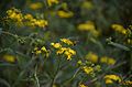
Callistemon citrinus
-
Cambewerra Nature Reserve Discovery
-
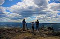
Field trip
-
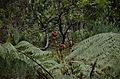
Plants
-
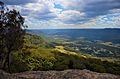
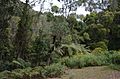
Landscape
-
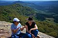
Enjoying the fresh air and the beautiful landscape while discussing the project
-
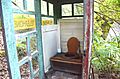
DIY Toilet in nature
-
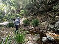
Zekai and David while taking photos of the waterfall


